
ColinJ
Puzzle game procrastinator!
- Location
- Todmorden - Yorks/Lancs border
Ok you lot ... I think I may have mentioned in passing that a couple of minor ailments prevented me organising any rides since June 2012? 
Well ... things were finally looking up by December 2013 so I am hoping to be ready to do another forum ride by the end of March this year. It is always possible that my health will let me down again, or that my fitness does not improve as quickly as hoped, but let's be optimistic and assume that I will make steady progress for the following 11 weeks.
If you fancy joining me for a forum ride, pencil in Sat, 29th March. I am mentioning this now because I know how many of you get booked up weeks in advance, so I am getting in first dibs on that date!
I HAVE TAKEN NOTE OF THE FEEDBACK BELOW AND CHANGED THE FORMAT OF THE RIDE TO ALLOW A CHOICE OF 103 KM OR 107 MILES!
The main loop is a 'long' metric century starting from Spring Wood picnic centre above Whalley and taking in the glorious Trough of Bowland. From the summit, it is mainly downhill to our cafe stop at Glasson Dock on the Lune estuary. We will return to Whalley via Longridge, Ribchester and Billington.
If you fancy doing a 'long' imperial century, there will be an earlier start from Hebden Bridge to Spring Wood, and back again at the end of the day.
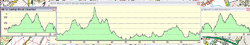
Here is the profile. The 103 km loop is the big bit in the middle. I have tacked on the rides from HB to Spring Wood and Spring Wood to HB. (The extra bits go via the Padiham Greenway, and the Old Roman Road via Read to avoid the busy, less scenic "Devil's Elbow" though we could take the main road if we wanted to.)

Here is a small scale map of the route:

For those of you with GPS devices, I have created 3 GPX files. The outward leg (Spring Wood - Trough of Bowland - Glasson Dock), the return leg (Glasson Dock - Longridge - Spring Wood), and the two linked together into one file (Spring Wood - Trough of Bowland - Glasson Dock - Longridge - Spring Wood). Links to the files are attached to this post.
PS I have now added a 4th GPX file, for the second half of the ride from Hebden Bridge to Burnley, starting at the traffic lights at Manchester Rd/A646. (To get to Manchester Rd, follow the A646 from HB to Todmorden, right at the mini-roundabout in Tod, eventually straight across at the junction with Bacup Rd and climb through Habergham Eaves to the TL at Manchester Rd.)
We come back 7.5 km along the outward leg after the cafe stop and that might look a bit confusing on your GPS screen if you try using a file for the full ride so you have the option of switching smaller files at the cafe stop, which is what I will do.
NB These are very detailed tracks which enable you to work out accurate distance and elevation data. I know from past experience that many GPS devices 'choke' on GPX files containing that many points so I highly recommend that you check that your device is okay with the files. If it isn't, you will have to use my files as a guide and plot simpler tracks just showing the turns using your mapping software or route mapping websites.
ColinJ Glasson Dock forum ride 29/3/2014 routesheet
SO = straight on
TL = traffic lights
O = roundabout
LHS = lefthand side
RHS = righthand side
L = left
R = right
BL = bear left
BR = bear right
sp = signposted
WHALLEY to GLASSON DOCK
Start SPRING WOOD picnic centre car park, A671, above Whalley
SO TL, descend hill
R at mini-O in WHALLEY at 0.8 km
L on B6246 at mini-O at 1.1 km
R at T at 5.4 km (sp Trough of Bowland)
SO (BL) at 6.5 km (sp Trough of Bowland)
SO at X at 7.9 km (sp Trough of Bowland)
SO at 9.4 km (sp Trough of Bowland)
SO at BASHALL EAVES at 10.2 km
Continue gradual climb to COW ARK at 13.6 km
BL and descend to Lees
R at T at 15.4 km (sp Trough of Bowland)
Stay on that road through WHITEWELL to Dunsop Bridge
SO at DUNSOP BRIDGE at 22.3 km (sp Trough of Bowland)
Ride glorious TROUGH OF BOWLAND & assemble at summit at 27.2 km for group photo
L sp Scorton at 31.5 km *** DO NOT RIDE PAST THIS TURN - EASY TO DO! ***
SO at 33.8 km
BL at 38.2 km
R at 38.7 km sp Bay Horse/Galgate
SO at X at 39.5 km sp Bay Horse/Galgate
SO at X at 40.6 km
SO at X at 41.1 km
SO at X at 42.4 km
SO at 43 km sp Galgate/Lancaster
BL under M6 at 44 km
Cross A6 SO at TL at 44.7 km in GALGATE
**CAUTION** s-bend under viaduct at 44.9 km!
BL at T at 45 km
Stay on that road until L on A588 at 48 km
Almost Immediate R sp Glasson Dock
SO at mini-O at 49.2 km
L at 49.7 km in GLASSON DOCK
Cafe stop at Lantern O'er Lune on RHS at 49.8 km
GLASSON DOCK TO WHALLEY
(Back the way we came, through GALGATE as far as FIVE LANE ENDS)
Distances from Glasson Dock cafe (Reset trip distance after cafe, otherwise
add 49.8 km to all distances below)
Back over bridge from cafe in GLASSON DOCK
R at T at 0.1 km
SO at mini-O at 0.6 km
L at onto A588 at 1.7 km
Immediate R at 1.8 km
Stay on that road until R at T at 4.8 km
**CAUTION** s-bend under viaduct at 4.9 km
SO A6 X-TL in GALGATE at 5.1 km
Continue under M6 to FIVE LANE ENDS, R at X at 7.4 km sp Bay Horse
L at T at 8.5 km sp Dolphinholme
SO at 9.0 km
SO at 10.5 km
L at T at 11.1 km
SO at T at 11.5 km
Over M6 at 12.6 km
R at T at 12.7 km
Back over M6 at 13.7 km
SO at X in SCORTON at 14.4 km
[Alternative cafe stop The Barn on R at 14.5 km]
L at T (before bridge) at 16.0 km
BL at 18.1 km
Back over M6 again(!) at 18.3 km
SO at 18.5 km
BR at 19.0 km
SO at 19.2 km
BL at 19.4 km
R at T on bend at 20.7 km
SO (BL) at T on bend at 21.3 km
SO at T at 21.9 km
SO (BR) at T at 22.1 km
BR sp Preston at 22.6 km
L at T at 23.2 km
BL at T at 24.2 km
BR at T at 25.0 km sp Beacon Fell Country Park
L at T at 26.7 km
SO at T at 27.6 km
SO at INGLEWHITE at 28.6 km
SO (BL) at T at 29.9 km
SO at X at 30.3 km
BR at T on bend at 31.0 km
SO at X at 32.0 km
SO (BR) at T on bend in LONGRIDGE at 35.2 km
SO at mini-O at 35.5 km
L at mini-O at 35.7 km
SO at mini-O at 36.1 km
L at T at 36.4 km
NB Toilets on LHS after turn may be open
BR downhill at White Bull at 36.5 km
Good 5.3 km main road descent to RIBCHESTER at 42.0 km
Stay on that road through the village and cross the R.Ribble at 43.3km
Immediate L onto lane after bridge sp for cyclists
STING IN THE TAIL a.k.a. ** ENGAGE GROVELLING GEAR NOW ** at 44.7 km
SO at T at 46.3 km
L at T at 47.2 km sp Brockhall Village
SO at T at 47.9 km
BR at 49.2 km
Climb over A59 at 50.4 km
L at mini-O in BILLINGTON at 50.8 km
Follow main road to WHALLEY at 52.6 km
R at mini-O and attack Col de Spring Wood if you have the energy & inclination!
Cross A671 at TL at X at 53.3 km to SPRING WOOD car park
THAT'S ALL FOLKS, HOPE YOU ENJOYED IT! - COLINJ
If you want to do the full 107 miles, meet at Market Place car park, Hebden Bridge [MAP] by 07:45 with a view to setting off at 08:00 sharp. If you are late, we will have already set off so chase us on the A646 towards Burnley and Padiham. You would have about 15 miles to catch us before we turn off onto the Padiham Greenway at Rose Grove. [ETA Rose Grove 09:10ish]
If you are just doing the main 103 km loop, meet at Spring Wood picnic centre car park off the A671 above Whalley by 09:45 with a view to setting off at 10:00 sharp. If you are late, we will have already set off so chase after us using your GPS/Map/Routesheet for guidance.
PS Usual CycleChat forum ride rules apply - nobody left behind (IF YOU SET OFF WITH US!), wait at the top of hills for others in your group. The rides are not fast and are more about chatting, laughing and scenery, so don't come if you are desperate to average more than (say) 10-12 mph. I guess that the 103 km loop will take 5-7 hours and HB to Whalley about 2 hours each way but it depends on the speed of the slowest rider.
Well ... things were finally looking up by December 2013 so I am hoping to be ready to do another forum ride by the end of March this year. It is always possible that my health will let me down again, or that my fitness does not improve as quickly as hoped, but let's be optimistic and assume that I will make steady progress for the following 11 weeks.
If you fancy joining me for a forum ride, pencil in Sat, 29th March. I am mentioning this now because I know how many of you get booked up weeks in advance, so I am getting in first dibs on that date!
I HAVE TAKEN NOTE OF THE FEEDBACK BELOW AND CHANGED THE FORMAT OF THE RIDE TO ALLOW A CHOICE OF 103 KM OR 107 MILES!
The main loop is a 'long' metric century starting from Spring Wood picnic centre above Whalley and taking in the glorious Trough of Bowland. From the summit, it is mainly downhill to our cafe stop at Glasson Dock on the Lune estuary. We will return to Whalley via Longridge, Ribchester and Billington.
If you fancy doing a 'long' imperial century, there will be an earlier start from Hebden Bridge to Spring Wood, and back again at the end of the day.
Here is the profile. The 103 km loop is the big bit in the middle. I have tacked on the rides from HB to Spring Wood and Spring Wood to HB. (The extra bits go via the Padiham Greenway, and the Old Roman Road via Read to avoid the busy, less scenic "Devil's Elbow" though we could take the main road if we wanted to.)
Here is a small scale map of the route:
For those of you with GPS devices, I have created 3 GPX files. The outward leg (Spring Wood - Trough of Bowland - Glasson Dock), the return leg (Glasson Dock - Longridge - Spring Wood), and the two linked together into one file (Spring Wood - Trough of Bowland - Glasson Dock - Longridge - Spring Wood). Links to the files are attached to this post.
PS I have now added a 4th GPX file, for the second half of the ride from Hebden Bridge to Burnley, starting at the traffic lights at Manchester Rd/A646. (To get to Manchester Rd, follow the A646 from HB to Todmorden, right at the mini-roundabout in Tod, eventually straight across at the junction with Bacup Rd and climb through Habergham Eaves to the TL at Manchester Rd.)
We come back 7.5 km along the outward leg after the cafe stop and that might look a bit confusing on your GPS screen if you try using a file for the full ride so you have the option of switching smaller files at the cafe stop, which is what I will do.
NB These are very detailed tracks which enable you to work out accurate distance and elevation data. I know from past experience that many GPS devices 'choke' on GPX files containing that many points so I highly recommend that you check that your device is okay with the files. If it isn't, you will have to use my files as a guide and plot simpler tracks just showing the turns using your mapping software or route mapping websites.
ColinJ Glasson Dock forum ride 29/3/2014 routesheet
SO = straight on
TL = traffic lights
O = roundabout
LHS = lefthand side
RHS = righthand side
L = left
R = right
BL = bear left
BR = bear right
sp = signposted
WHALLEY to GLASSON DOCK
Start SPRING WOOD picnic centre car park, A671, above Whalley
SO TL, descend hill
R at mini-O in WHALLEY at 0.8 km
L on B6246 at mini-O at 1.1 km
R at T at 5.4 km (sp Trough of Bowland)
SO (BL) at 6.5 km (sp Trough of Bowland)
SO at X at 7.9 km (sp Trough of Bowland)
SO at 9.4 km (sp Trough of Bowland)
SO at BASHALL EAVES at 10.2 km
Continue gradual climb to COW ARK at 13.6 km
BL and descend to Lees
R at T at 15.4 km (sp Trough of Bowland)
Stay on that road through WHITEWELL to Dunsop Bridge
SO at DUNSOP BRIDGE at 22.3 km (sp Trough of Bowland)
Ride glorious TROUGH OF BOWLAND & assemble at summit at 27.2 km for group photo
L sp Scorton at 31.5 km *** DO NOT RIDE PAST THIS TURN - EASY TO DO! ***
SO at 33.8 km
BL at 38.2 km
R at 38.7 km sp Bay Horse/Galgate
SO at X at 39.5 km sp Bay Horse/Galgate
SO at X at 40.6 km
SO at X at 41.1 km
SO at X at 42.4 km
SO at 43 km sp Galgate/Lancaster
BL under M6 at 44 km
Cross A6 SO at TL at 44.7 km in GALGATE
**CAUTION** s-bend under viaduct at 44.9 km!
BL at T at 45 km
Stay on that road until L on A588 at 48 km
Almost Immediate R sp Glasson Dock
SO at mini-O at 49.2 km
L at 49.7 km in GLASSON DOCK
Cafe stop at Lantern O'er Lune on RHS at 49.8 km
GLASSON DOCK TO WHALLEY
(Back the way we came, through GALGATE as far as FIVE LANE ENDS)
Distances from Glasson Dock cafe (Reset trip distance after cafe, otherwise
add 49.8 km to all distances below)
Back over bridge from cafe in GLASSON DOCK
R at T at 0.1 km
SO at mini-O at 0.6 km
L at onto A588 at 1.7 km
Immediate R at 1.8 km
Stay on that road until R at T at 4.8 km
**CAUTION** s-bend under viaduct at 4.9 km
SO A6 X-TL in GALGATE at 5.1 km
Continue under M6 to FIVE LANE ENDS, R at X at 7.4 km sp Bay Horse
L at T at 8.5 km sp Dolphinholme
SO at 9.0 km
SO at 10.5 km
L at T at 11.1 km
SO at T at 11.5 km
Over M6 at 12.6 km
R at T at 12.7 km
Back over M6 at 13.7 km
SO at X in SCORTON at 14.4 km
[Alternative cafe stop The Barn on R at 14.5 km]
L at T (before bridge) at 16.0 km
BL at 18.1 km
Back over M6 again(!) at 18.3 km
SO at 18.5 km
BR at 19.0 km
SO at 19.2 km
BL at 19.4 km
R at T on bend at 20.7 km
SO (BL) at T on bend at 21.3 km
SO at T at 21.9 km
SO (BR) at T at 22.1 km
BR sp Preston at 22.6 km
L at T at 23.2 km
BL at T at 24.2 km
BR at T at 25.0 km sp Beacon Fell Country Park
L at T at 26.7 km
SO at T at 27.6 km
SO at INGLEWHITE at 28.6 km
SO (BL) at T at 29.9 km
SO at X at 30.3 km
BR at T on bend at 31.0 km
SO at X at 32.0 km
SO (BR) at T on bend in LONGRIDGE at 35.2 km
SO at mini-O at 35.5 km
L at mini-O at 35.7 km
SO at mini-O at 36.1 km
L at T at 36.4 km
NB Toilets on LHS after turn may be open
BR downhill at White Bull at 36.5 km
Good 5.3 km main road descent to RIBCHESTER at 42.0 km
Stay on that road through the village and cross the R.Ribble at 43.3km
Immediate L onto lane after bridge sp for cyclists
STING IN THE TAIL a.k.a. ** ENGAGE GROVELLING GEAR NOW ** at 44.7 km
SO at T at 46.3 km
L at T at 47.2 km sp Brockhall Village
SO at T at 47.9 km
BR at 49.2 km
Climb over A59 at 50.4 km
L at mini-O in BILLINGTON at 50.8 km
Follow main road to WHALLEY at 52.6 km
R at mini-O and attack Col de Spring Wood if you have the energy & inclination!
Cross A671 at TL at X at 53.3 km to SPRING WOOD car park
THAT'S ALL FOLKS, HOPE YOU ENJOYED IT! - COLINJ
If you want to do the full 107 miles, meet at Market Place car park, Hebden Bridge [MAP] by 07:45 with a view to setting off at 08:00 sharp. If you are late, we will have already set off so chase us on the A646 towards Burnley and Padiham. You would have about 15 miles to catch us before we turn off onto the Padiham Greenway at Rose Grove. [ETA Rose Grove 09:10ish]
If you are just doing the main 103 km loop, meet at Spring Wood picnic centre car park off the A671 above Whalley by 09:45 with a view to setting off at 10:00 sharp. If you are late, we will have already set off so chase after us using your GPS/Map/Routesheet for guidance.
PS Usual CycleChat forum ride rules apply - nobody left behind (IF YOU SET OFF WITH US!), wait at the top of hills for others in your group. The rides are not fast and are more about chatting, laughing and scenery, so don't come if you are desperate to average more than (say) 10-12 mph. I guess that the 103 km loop will take 5-7 hours and HB to Whalley about 2 hours each way but it depends on the speed of the slowest rider.
Attachments
-
 Trough of Bowland forum ride 29-3-14.gif48.6 KB · Views: 668
 -
Spring Wood Whalley - Trough of Bowland - Glasson Dock.gpx14.2 KB · Views: 155
-
Glasson Dock - Longridge - Spring Wood Whalley.gpx12.8 KB · Views: 113
-
Spring Wood Whalley - Trough of Bowland- Glasson Dock - Longridge - Spring Wood, Whalley.gpx26.7 KB · Views: 132
-
Manchester Rd Burnley to Spring Wood Whalley via Greenway and Old Roman Rd.gpx5.7 KB · Views: 159
Last edited:

 . It would be good to meet up.

