Lard Armstrong
Veteran
- Location
- Milton Keynes
But how about printing ?
Print Screen will work, especially if you can crop the tool bars out using a basic ''paint'' type program. I use mapyx quo, which is a free download that supports printing and you can download the open cycle maps for free (OS1:2500 tiles are about £2 each). Though on occasion I have used print screen for emailing routes to friends who don't use mapping software.But how about printing ?
There's probably a better way but if I want a map, I plot my route quickly with online mapping (I prefer RWGPS) and export the gpx to MM.Any decent free digital mapping software which allows printing ?
I have had Memory Map for years, which does the job, but is really clunky and time consuming.
MapMyRide prints, but only Pro version.
Any suggestions ?
I might give that a go because plotting long routes in MM can be very tedious.There's probably a better way but if I want a map, I plot my route quickly with online mapping (I prefer RWGPS) and export the gpx to MM.
Bikehike does it for me, plot, print and go.... though tbh I'm usually following the route on a GPS not a paper printed map.But how about printing ?
just curious - is there a reason you don't use the print option within bikehike? it takes all the borders out for you and works...Print Screen will work, especially if you can crop the tool bars out using a basic ''paint'' type program. I use mapyx quo, which is a free download that supports printing and you can download the open cycle maps for free (OS1:2500 tiles are about £2 each). Though on occasion I have used print screen for emailing routes to friends who don't use mapping software.


you like birmingham don't you?Bikehike doesn't work correctly on my ipad. When plotting it jumps all over the country, literally. If I touch the screen to plot the route, for example the top of my street, bikehike will plot a route to Birmingham etc etc.
No, no reason, it's just I don't start off by using bikehike. Though, having just had a look at it, I might experiment with it in the future!just curious - is there a reason you don't use the print option within bikehike? it takes all the borders out for you and works...
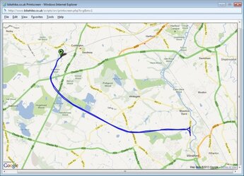
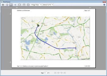
comes up (eventually) with this screen and you just press ctrl+P or right click and select print, to print... just have to match your landscape/portrait options with whatever you selected when the bikehike script ran... 2nd image is what you get to see when it is printed directly from bikehike. you can zoom in on the 1st screen by double clicking, though I have yet to suss out how to zoom vback out without starting over.
View attachment 17357 View attachment 17358

Bikehike doesn't work correctly on my ipad. When plotting it jumps all over the country, literally. If I touch the screen to plot the route, for example the top of my street, bikehike will plot a route to Birmingham etc etc.
