migrantwing
Veteran
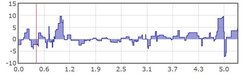
Created a route in RWGPS and uploaded it to Bike Hike to check hill gradient. RWGPS shows two hills on my route, one with a gradient maxing out at 5.9% and another at 6.9%. When I upload it to Bike Hike, these values are 10% and 9%, respectively. 1 or 2% here and there is OK, but what is causing these quite prominent differences?
I've saved these routes as gpx, tcx and fit files, but they are all way off.
I've saved these routes as gpx, tcx and fit files, but they are all way off.