Fab Foodie
hanging-on in quiet desperation ...
- Location
- Kirton, Devon.
Character forming!48 miles into a 20mph headwind does not appeal.

Character forming!48 miles into a 20mph headwind does not appeal.
Fully formed, thank you very much......Character forming!

I was thinking about me!Fully formed, thank you very much......
I was thinking about me!
Lost cause

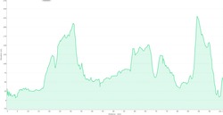
Thank you for the plots. It looks to me as though Hill X is about 100 metres rise over about 3.5 km. Ditchling is about 160 over 3 km. I always thought that Ditchling was about 0.8 miles from the cross-roads to the top, so I may have scrambled something.for comparative purposes, this is the elevation plot of a Brighton FNRttC. as above, keep the scale of thexy axis in mind (yet again, in meters) (x axis is in km)

how come the lowest we go in the Rotherhithe tunnel is 2.1metres? There are low tides lower than that. And do we have to go to the top of the Monument?I've taken dellzeqq's route, and converted it to a GPSies track, from which you can download GPX and so forth. As ever, the normal rules apply, so the route may change at any time, with no warning, this is for guidance only.
First Half (up to the Dartford services)
Second Half
 work have put a stick in the spokes for me.
I can't be bothered with drawing diagrams of this, but looking at the 1:50000 OS Mapping on BikeHike, the contours on this "hill" aren't even remotely as close together as they are on Ditchling Beacon. I don't think it's worth worrying about.for comparative purposes, this is the elevation plot of a Brighton FNRttC. as above, keep the scale of thexy axis in mind (yet again, in meters) (x axis is in km)
Hipflask prepared. Now I just need to decide what to wear to give some hope of finishing the night warm and dry.
Earwarmers are even better ....Armwarmers are good.
actually, it's one mouse click on BasecampI can't be bothered with drawing diagrams of this
judging by the short sharp showers around here right now Arm-bands might be more appropriate ....Armwarmers are good.
Thank you for the plots. It looks to me as though Hill X is about 100 metres rise over about 3.5 km. Ditchling is about 160 over 3 km. I always thought that Ditchling was about 0.8 miles from the cross-roads to the top, so I may have scrambled something.