Google maps Sustrans route catastrophe

Page may contain affiliate links. Please see terms for details.

albion

Legendary Member
Location
Gateshead
Having come across a few recent route errors it appears to me Google maps has removed much of the National cycle route.
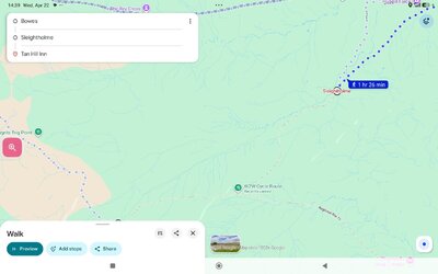
Try getting from Bowes (Barnard Castle) to the Tan Hill Inn and you will see what I mean, the correct cycling route being a near straight line along national route 70, that section being the very popular Sleightholme Moor.

There are other instances, it also screwing up walking routes, not that they were good anyway.
I am not quite sure what is going on but is this a side effect of Google crazy routes or are they mainly still there?
 
Last edited:
Yes, they've made some alterations near me. I'm inclined to say they're not "wrong", as they've downgraded some bits that I KNOW to have crap surfaces which have deteriorated in the last couple of years!

But frankly (and I don't mean to sound unsympathetic, I'm sure this isn't news to you) Google is rubbish for plotting bike/pedestrian routes anyway. It can help with some general ideas and overview of course.
 
OP
OP
albion

albion

Legendary Member
Location
Gateshead
It is my quick and easy first stage planner. But removing actual walking and cycling routes compounds the madness.
Strangely, I suspect the full on crazy life risking high mountain bridleway routes are still there.
So its route grabber system has likely malfunctioned on some OS or Sustrans change.
 
OP
OP
albion

albion

Legendary Member
Location
Gateshead
Yes, they've made some alterations near me. I'm inclined to say they're not "wrong", as they've downgraded some bits that I KNOW to have crap surfaces which have deteriorated in the last couple of years!

But frankly (and I don't mean to sound unsympathetic, I'm sure this isn't news to you) Google is rubbish for plotting bike/pedestrian routes anyway. It can help with some general ideas and overview of course.

It is certainly an error or manor downgrade. They even lost the pennine way walking route too there.
I just checked. Normal mad routes elsewhere through bogs etc are still there.
 

Attachments

  • Screenshot_2026-04-22-14-39-31-623_com.google.android.apps.maps.jpg
    Screenshot_2026-04-22-14-39-31-623_com.google.android.apps.maps.jpg
    83.4 KB · Views: 0
OP
OP
albion

albion

Legendary Member
Location
Gateshead
I use https://cycle.travel quick and easy and free and designed to give good cycling routes with a range of options as to the nature of the rote (eg paved, allow unpaved, cycle route, etc.).

I use Organic Maps which does great offline planning and gets that route exact for both walking and cycling, the walking route adhering to the pennine way more fully. However,my initial overview plan is always Google maps, probably because I use it to navigate by voice to en-route shops. I rarely bother with a screen map whilst actually cycling.
I suspect Organic Maps and its offshoot CoMaps is much like Komoot but fully offline, both using OSM as the base.

Another thing I noticed is that Google is labelling some cycle routes and not others. So you can get route 7, route 71 but not labelling for route 70.
 
Last edited:
Top Bottom