map creation tool/software

Page may contain affiliate links. Please see terms for details.

Jack Lloyd

Regular
I've recently moved back to university in Newcastle, over the summer I brought a road bike, and went riding everyday.

Back home I know the area etc, so didn't need any maps, but up here I don't really know why way around using the roads etc, so I was wondering if anyone here can recommened and map creating tools aimed for cyclists, I tried google maps but it seems to take you along dual carriage ways (which IMO even though it legal its a lot more dangerous), so IMO that doesn't really work.

Thanks.
 
Last edited:

BrynCP

Über Member
Location
Hull
You can ride on most dual carriageways if you wish (obviously excl. Motorways). Not that I would on some of them. The other thing to be careful of with Google is it sending you down private roads, which you have no right of way on. What I like about Google is if you click the streetview man, you get a good idea about what is private or not, based on if the Google Car went down, and I often use it to judge how safe the road looks.

Did you choose the "Get Around by Bicycling" or click on the picture of a bike after entering a from/to, as I find it typically picks the much quieter roads by default and never had it pick the dual carriageways by default around here.
 

deptfordmarmoset

Full time tea drinker
Location
Armonmy Way
cyclestreets.net will give you 3 ''traffic light'' options. I find I often end up on the amber routes because they're not super noisy. No good for planning a loop ride though, because the quickest way from A to A is to simply stay at A.
 
OP
OP
Jack Lloyd

Jack Lloyd

Regular
You can ride on most dual carriageways if you wish. Not that I would on some of them. The other thing to be careful of with Google is it sending you down private roads, which you have no right of way on. What I like about Google is if you click the streetview man, you get a good idea about what is private or not, based on if the Google Car went down, and I often use it to judge how safe the road looks.

Did you choose the "Get Around by Bicycling" or click on the picture of a bike after entering a from/to, as I find it typically picks the much quieter roads and never had it pick the dual carriageways around here.
Yeah, riding on dual carriage seems unsafe, even as a cyclist I would be a bit put back seeing a cyclist on one. all the trucks too.

cyclestreets.net will give you 3 ''traffic light'' options. I find I often end up on the amber routes because they're not super noisy. No good for planning a loop ride though, because the quickest way from A to A is to simply stay at A.
Quick test of cyclestreets and I'm already liking it. I will have to look more in depth tomorrow morning!
 

moo

Veteran
Location
North London
http://www.strava.com/routes/new

Once created choose Export to get the gpx file.
 
Location
Pontefract
rwgps
it is the easiest route planner I have used, set it for car walk or bike, and different maps to chose from.
I download either a gpx for navigation on my 705 or a tcx for a course file, edge 500
 
Location
Pontefract
@Richard Fairhurst
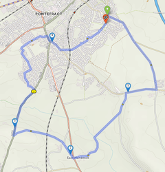
upload_2014-9-29_19-59-32.png

not exactly the route you would expect. I know you can drag it. Not knocking it found it nice and easy to use, must try a tcx course from it. RWGPS also is like strava in that you can create segments and it keeps a log of your rides also has its own phone app.
 
Location
Pontefract
It doesn't like busy A roads which is why it'll send you off the A639 after mile 5. Otherwise I think it's plotted a course between all the points you entered - but I might have misunderstood. :smile:
Not knocking it, it just not a route you would take, but its taking you off the main road to join it further down then to cross it come back to take the left instead of just going straight on and do the right, unless it thinks that coming out of a junction to do a right is less dangerous, I know that road and its none to nice.
 
Top Bottom