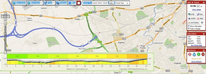
Show us your commute elevation profile

Page may contain affiliate links. Please see terms for details.

Maizie

Guru
Location
NE Hertfordshire
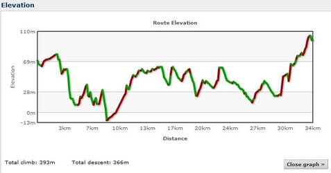
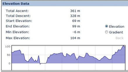
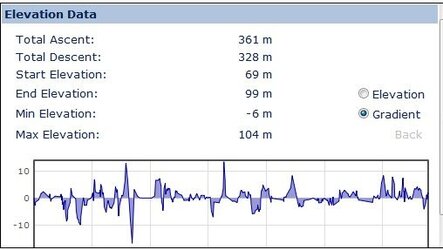
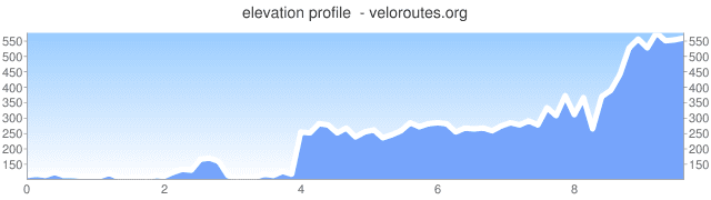
This is the route to work, just reverse it for the way home. More climbing on the way home. It's probably not actually hilly by any Real Cyclist's standard, but it kills me (only done it twice - changed site I work at this week :smile: )

commute.JPG
 

jimboalee

New Member
Location
Solihull
My ride to work profile resembles a bath tub.

I ride along the West Midlands plateau at 430 ft until it drops to the river Avon valley at Hatton down a 10% to 120 ft.
Eight miles of flat basin is followed by Chesterton bank, a 10% incline back up to 420 ft.
 
This is my current commute just now although I'm not doing it too regularly :-( just once or twice a fortnight and once the uni term begins again it'll only be the last 8km.
That other web site whilst being time consuming reported that it was a max of 29% but I seriously doubted it an chose Bikely instead and got bored so I decided to repeat it in Bikehike. Bikehike shows a max of 12-14%, thats more likely. It also show 30m less climbing than Bikely. Circa 45m of the climb doesn't exist it crossing the FRB and I actually stay at that level rising a metre or two rather than falling to sea level 0m. Now I've got the bug I might look at it in Mapmyride and RidewithGPS.
 

Attachments

  • Commute.jpg
    Commute.jpg
    24 KB · Views: 20
  • Bikehike Elevation.jpg
    Bikehike Elevation.jpg
    20.5 KB · Views: 27
  • Bike Hike Gradient.jpg
    Bike Hike Gradient.jpg
    22.9 KB · Views: 16
This is my current commute just now although I'm not doing it too regularly :-( just once or twice a fortnight and once the uni term begins again it'll only be the last 8km.
That other web site whilst being time consuming reported that it was a max of 29% but I seriously doubted it an chose Bikely instead and got bored so I decided to repeat it in Bikehike. Bikehike shows a max of 12-14%, thats more likely. It also show 30m less climbing than Bikely. Circa 45m of the climb doesn't exist it crossing the FRB and I actually stay at that level rising a metre or two rather than falling to sea level 0m. Now I've got the bug I might look at it in Mapmyride and RidewithGPS.

Its pretty flat in Mapmyride but Ride with GPS sort of agrees with the first two 396m of climbing 15.9% max. My guess out of all the sites Bikehike seems to be the most accurate.
 

Attachments

  • Mapmyride.jpg
    Mapmyride.jpg
    149.1 KB · Views: 33
  • RidewithGPS Profile.jpg
    RidewithGPS Profile.jpg
    14.2 KB · Views: 27

nasserblue

Active Member
Location
London
Ah like this... (The cunning "Add to Post" link)

ealing_stpauls.JPG
 

Davywalnuts

Chief Kebab Taster
Location
Staines!
I was going to say:-

Staines _________________________ Whitton...

But it seems its like this:-

elevation_graph%5B1%5D.jpg


Quite mystified at it all really...
 

al78

Guru
Location
Horsham
Here's mine. Takes me 5-10 mins longer getting to work than coming home.
 

Attachments

  • elevation_graph.png
    elevation_graph.png
    5 KB · Views: 32
Top Bottom