The Rail Enthusiast thread

Page may contain affiliate links. Please see terms for details.

Mike_P

Guru
Location
Harrogate
Two ex-Great Western lovelies from my ride yesterday.

1) Wilmcote station just north of Stratford on Avon, retaining its classic GWR rural station look
View attachment 723922

2) some lower quadrant signalling weirdness at Droitwich. Can someone tell me what sort of signals these are?
nb. if you squint under the bridge you can just about make out another set of lower-quadrant signals.

View attachment 723923

Platform starting signals and probably advanced starter, so allowing a train to leave the station even if the line ahead is occupied so another train can stop at the stop at the station. In some cases absolute block signalling has dispensed with the platform starter and for example Beeston (Notts) westbound has, unless it's been changed on recent years, a block signal immediately before the platform that really annoyed passengers wanting to leave a train.
 
Last edited:

Sallar55

Veteran
1000023065.jpg


1000023063.jpg


1000023067.jpg


1000023068.jpg


1000023069.jpg


1000023070.jpg


1000023075.jpg


1000023076.jpg


1000023095.jpg

Some pics and last WW1 war supply trains for the western front.
 

Attachments

  • 1000023071.jpg
    1000023071.jpg
    205.5 KB · Views: 8
Local train in Tübingen West railway station, south Germany, last week.

2024_03_15_Tübingen_05.jpg


This is an Alsthom Coradia Continential, transferred to this region last month; they are about 16 years old and newer versions have a very different end design. The line from Tubingen to Herrenberg has just been electrified and these replace the class 350 diesel railcars that used to run the route.

It looks like the units are being refurbished; there was one in the new "Bwegt" livery that is becoming standard on local rail services in Baden-Württemberg. Unfortunately I wasn't able to get a good picture of it, but the new colour scheme seems to suit it:


2024_03_15_Tübingen_04.jpg
 
Saturday 30th

Normanton Station
As seen from the Altofts Road bridge (whilst walking the Dog)
Normanton
Wakefield

Once a highly important strategic junction, dubbed The Crewe Of The North
The platform was almost a 1/4mile long in its prime, it was first opened in 1840
Queen Victoria, & Benjamin Disraeli are amongst the people who used the (adjacent) Station Hotel..... not together, I assume??
The Hotel was across a footbridge, to the (replacement/new) stone building seen above the retaining wall

IMG_9672.jpeg


Date stated, 1961; https://www.geograph.org.uk/photo/2010549
NLS 25" map, use the blue slider to see it now; https://maps.nls.uk/geo/explore/#zoom=16.2&lat=53.70089&lon=-1.42345&layers=168&b=1&o=100

Mid 70's?
Some station buildings are still in existance, the Station Hotel is now The Flying Scotsman
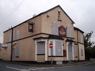
The Talbot
can be seen as the first building on the left, demolished* quite a few years ago, but the street is still Talbot Street
16406893_1980114225542294_6172304409244182296_n - Copy.jpg


Early 70s?

16602669_717012291790030_9186357190256736713_n.jpg


The extent of the sidings!!
(& they continued under the bridge too, reconsult the map)
17353576_10102632663887875_7793604499466641858_n.jpg


Mid 70s?
Looking towards the bridge (Castleford/Leeds/York trains)
24059101_10155899641949184_2571420564047475587_n.jpg


EDIT; Monday 1st @ 09:30
Flying Scotsman pub, during demolition, to build the apartments seen in first photograph (circa 2002?)
Normanton. Flying Scotsman.jpg


The abutment, for the footbridge, to the Station Hotel
Normanton. Flying Scotsman. Rear Station Access.JPG


* The Talbot
Awaiting demolition
(Talbot Street to its left, Railway Terrace to the right)
Normanton. Talbot.jpg
 
Last edited:
Thursday 4th

En-route to my parents
I know that this historic wagon-way had been lifted, but it’s probably the first time l’ve been along Lime Pit Lane, in the daylight this year

It was a 3foot(??) gauge railway that led from early incarnations of what became Lofthouse Colliery (of the famous flooding/sad deaths)
The name is still debated

Locally it’s known as the ‘Nagger Lines’
(as in ‘nag’, the colloquial term for a Horse)
There’s the other school of thought that it’s derived from Navigation, as it head to the Aire & Calder Navigation Canal

It crossed the road since laying, but recently there’s been complaints about damage to vehicle tyres
Personally, l think that’s utter rubbish
I crossed it untold times on the bike, & have never suffered any punctures/wheel damage there, even when on ‘20’ section tyres!


IMG_9727.jpeg


IMG_9728.jpeg


The rails
IMG_9729.jpeg


https://www.geograph.org.uk/photo/6921223

Further along (200yards) prior to crossing Aberford Road/A642, another’way’ has a blue plaque
(slightly closer to jct30/M62)
https://www.geograph.org.uk/photo/6222148


https://www.bbc.co.uk/news/uk-england-leeds-66108903.amp

https://www.canalworld.net/forums/index.php?/topic/118891-lime-kiln-lane-tramway/

The ‘Naggers’ are to the south in this 1820s map
’Lake Lock’, of the blue plaque is the one with the ‘sidings’ at the River Calder

IMG_9731.jpeg
 
Last edited:

Mike_P

Guru
Location
Harrogate
I've always liked 31's. Possibly because they really shouldn't have survived half as long as they did with their slightly bonkers wheel arrangement, but somehow kept being too useful to get rid of.
Two memories of 31s;
1. A pair being tasked with a Hull-Carlisle which I caught on the return and their performance on the S&C was summed up by a fellow passenger as one to heat and one to pull and neither did well.
2. A single 31 on far too many coaches on a Birmingham-Norwich whereby to get enough power to crawl out of New Street drivers would switch the ETH off
 

rogerzilla

Legendary Member
I think they were just too numerous to write off, and their very low axle loading was useful. They were a disaster really - underpowered, all the original unreliable Mirrlees prime movers had to be replaced with EE engines - which is when they changed from class 30 to 31 on TOPS, and a face only a mother could love.
 
Top Bottom