England : East Yorkshire Any members from East Yorkshire area ?

Page may contain affiliate links. Please see terms for details.

RhythMick

Über Member
Location
Barnsley
I've organised a family holiday from next Friday up near Brandesburton. I'm considering cycling there from home while SWMBO drives over. Obviously I don't know the area very well so just looking for a little route advice if any locals can help.

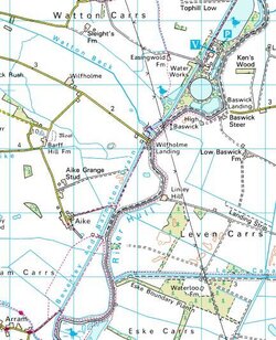
The cottage is kind of in the middle of nowhere so the default is follow the road around through Brandesburton (about 74 miles from Barnsley). However Open Cycle Maps shows a path from Arram along the Beverley and Barmston Drain, past Wilfholme Landing and the Waterworks, alongside the River Hull and delivering me to Struncheon Hill Farm where I'm staying. Screen shots below show Open Cycle Map and also the OS map.

Is this path cyclable ? If so it cuts almost 8 miles off my route which could be handy. However if I hit an impassable obstruction it will add more as I circle back. Open Cycle Map shows (most) of it as a green path which I think is cyclable.


Open Cycle Map
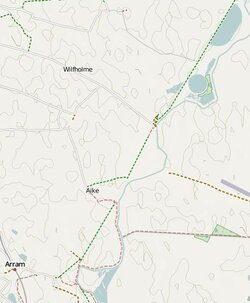
Arram 1.JPG

OS
OS1.JPG
 

Soltydog

Legendary Member
Location
near Hornsea
Sorry cant help with that, but if you have to cycle out of Beverley on the A1035 take extra care as I find it the worst road round here for cycling on :sad: Many motorists round here are courteous to cyclists, theres normally only the odd idiot out here, but this road seems to attract them.
 
OP
OP
R

RhythMick

Über Member
Location
Barnsley
Fortunately not. Heading to Market Weighton, South Dalton, Lockington, and then across towards Aike then Wilfholme Landing. As long as I can cycle along the bank of the river I'm golden.
 

MockCyclist

Well-Known Member
No! You can't cycle along the riverbank from Aike to Wilfholme.
From Aike, it's a little-used bridlepath, somewhat difficult with a bike, but it changes to a footpath part way, just where the parish boundary changes. There's a warning sign at the start of the bridleway which makes it plain, you are not welcome to use the footpath as a bridleway.
If you look on OSM it's clear. I mapped it.
 
OP
OP
R

RhythMick

Über Member
Location
Barnsley
No! You can't cycle along the riverbank from Aike to Wilfholme.
From Aike, it's a little-used bridlepath, somewhat difficult with a bike, but it changes to a footpath part way, just where the parish boundary changes. There's a warning sign at the start of the bridleway which makes it plain, you are not welcome to use the footpath as a bridleway.
If you look on OSM it's clear. I mapped it.

Thanks MC.

How about from Wilfholme to Struncheon?
 

MockCyclist

Well-Known Member
Well when I map a bridleway it appears as a green, short dashed line. Legal for bikes of course but not always suitable.

You need to be at Struncheon Hill Farm. From Watton, you can get to Angram Farm and at that point there's a service road to the water works past Easingwold Farm. From there you can cycle along the riverbank to Struncheon Hill, it's just a grassy bank, progress won't be great but it's perfectly do-able. I've been that way, it's all legit.
From Market Weighton, you can take the rail trail to Kiplingcotes Station, or just take the road if you prefer, then South Dalton, Holme on the Wolds, Lockington, Kilnwick, Cawkeld if you want a bit more scenic, then Watton. It's a very pleasant route.
 
OP
OP
R

RhythMick

Über Member
Location
Barnsley
MC thanks v much. Just the kind of advice I was hoping for.

Could be late and I could be tired, so I'll avoid the grassy bank and take your 2nd route.
 
OP
OP
R

RhythMick

Über Member
Location
Barnsley
Interesting also to see the differences between Open Cycle Map and Open Street Map.

OCM shows it as a green dotted cycle path all the way through, but switching to OSM shows the change to a path at the Parish Boundary as you said.

Once again thanks for the advice.
 

MockCyclist

Well-Known Member
Sorry I must have been unclear, from the water works you must follow the grassy bridlepath to get to Struncheon. Here's the exact path I'm talking about (through those trees to the left of the picture).
20110627%23IMG_1110.jpg
 
OP
OP
R

RhythMick

Über Member
Location
Barnsley
Ouch - definitely looks like hard and slow progress through there. Will avoid. Thanks.

Howdenshire Rail Trail from Bubwith to Market Weighton looks nice though, thanks for that.
 

MockCyclist

Well-Known Member
I haven't done the Rotsea road, so I don't know. I just had a look at Google Street View and the white road part looks suspiciously like a private farm access.
 
Top Bottom