I've organised a family holiday from next Friday up near Brandesburton. I'm considering cycling there from home while SWMBO drives over. Obviously I don't know the area very well so just looking for a little route advice if any locals can help.
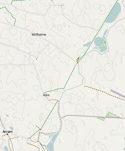
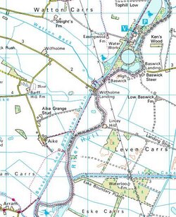
The cottage is kind of in the middle of nowhere so the default is follow the road around through Brandesburton (about 74 miles from Barnsley). However Open Cycle Maps shows a path from Arram along the Beverley and Barmston Drain, past Wilfholme Landing and the Waterworks, alongside the River Hull and delivering me to Struncheon Hill Farm where I'm staying. Screen shots below show Open Cycle Map and also the OS map.
Is this path cyclable ? If so it cuts almost 8 miles off my route which could be handy. However if I hit an impassable obstruction it will add more as I circle back. Open Cycle Map shows (most) of it as a green path which I think is cyclable.
Open Cycle Map

OS

The cottage is kind of in the middle of nowhere so the default is follow the road around through Brandesburton (about 74 miles from Barnsley). However Open Cycle Maps shows a path from Arram along the Beverley and Barmston Drain, past Wilfholme Landing and the Waterworks, alongside the River Hull and delivering me to Struncheon Hill Farm where I'm staying. Screen shots below show Open Cycle Map and also the OS map.
Is this path cyclable ? If so it cuts almost 8 miles off my route which could be handy. However if I hit an impassable obstruction it will add more as I circle back. Open Cycle Map shows (most) of it as a green path which I think is cyclable.
Open Cycle Map

OS


 Many motorists round here are courteous to cyclists, theres normally only the odd idiot out here, but this road seems to attract them.