Anything better than a 1:50 for day rides?

Page may contain affiliate links. Please see terms for details.

Shack

Senior Member
Hi all I've been scouring around for different, or better maps for day rides and looking through my big box of maps (ranging from car oriented 1 map for the whole country, down to small area specific sustrans maps) and I can find anything that gives me enough detail to explore off piste a little but still have the breadth of detail and cover enough area.
Am I missing something obvious?
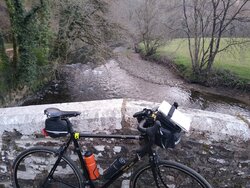
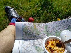
I use 1:25 for walking and tend to use the os adventure range (the laminated ones) but they are pretty bulky esp if you have/ need a couple for the ride (see attached from last week)
Maybe I've hit gold already? What do folks use/ think?
 

Attachments

  • IMG_20210414_193817941.jpg
    IMG_20210414_193817941.jpg
    345.7 KB · Views: 16

Dan77

Senior Member
Location
Worcester
Komoot.

Join the 21st century :laugh:
 
I plot on 1:25,000 on Memory Map.
I print out 1:50,000 of the roue to take with me I.C.O.N.
If I plot accurately my Etrex gives decent TBT and I seldom need to refer to printed out maps.
The secret, as ever, is in the preparation.
 

roubaixtuesday

self serving virtue signaller
Goldeneye do a series of 1:100,000 but only for a very limited number of areas of the country.

I use the Peak District and Dales ones, they are excellent.

https://www.goldeneyeguides.co.uk/cycling-country-lanes
 
OP
OP
Shack

Shack

Senior Member
Thanks for the link, I've already got and used the Cornish one, unfortunately much if Devon although beautiful wouldn't create enough sales to warrant production
 

ColinJ

Puzzle game procrastinator!
I plot on 1:25,000 on Memory Map.
I print out 1:50,000 of the roue to take with me I.C.O.N.
If I plot accurately my Etrex gives decent TBT and I seldom need to refer to printed out maps.
The secret, as ever, is in the preparation.
I have all of GB on MM at 1:250,000, 1:50,000, 1:25,000 and 1:10,000 scales. By the wonders of modern technology, all of that fits into a fraction of the SD card on my phone. If I want to consult a map when I am out, I just take a look at the phone.

I normally plan exactly where I am going beforehand and generate a GPX file which I upload to my Garmin device. I was out on a walk recently though and decided not to walk up a slope only to come down the other side again a few hundred metres later, when there appeared to be a perfectly good path following the contour line round the hillside. A glance at MM confirmed that to be the case so we took the diversion.

Sounds like you *might* be going Off Road?
If so, the 1:50k maps aren't too bad.
If road only, 1:100k is much better (if you can find one... )
I don't agree with you there, unless you are sticking to main roads, and easy-to-follow offroad routes... :okay:

1:100,000 wouldn't give you much detail of networks of tiny lanes, whereas 1:50,000 is perfect for that. 1:25,000 is too detailed for road use.

Similarly, 1:50,000 is not detailed enough for serious offroad use, whereas 1:25,000 is perfect.

In cities and towns, the 1:10,000 comes into its own. The version I have is not quite perfect in that a few roads are not labelled but I can see how they all join together.
 

Ming the Merciless

There is no mercy
Location
Inside my skull
The road atlas you can get in most garages work pretty well if it’s on road. Plan your day ride on them, rip out the pages you want, write down a list of villages and / or towns in sequence you want to pass through them. Use high lighter pen on page ripped out. If you want.
 

Drago

Legendary Member
Sign up as a search and rescue volunteer and Viewranger will give you free acdess to the UK a for your phone at 1:25000. Advance to Search Manager level and Mapyx will do the same, but at 1:10000, which is truly superb. These are the tools I use, albeit on my tablet.

You can get mastermap at 1:1250, but thats a bit excessive.
 
Top Bottom