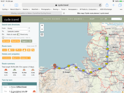
Chorley, Lancashire to Wales

Page may contain affiliate links. Please see terms for details.

wardster

New Member
Location
Preston
Hi

I'm planning on following Google Maps to bike it to Wales. I'm going to go around the Mersey, so it will be around 100 mile trip. I'll be catching the train back ! :smile:

This will be my longest distance so far, and I'm new to following Google Maps so would appreciate any advice/tips!

Thanks

Luke
 

mythste

Veteran
Location
Manchester
Don't.

Well, sort of don't. Google maps will route you onto anything that is classed as a "cycle path", even if it is a sliver of rutted path that runs next to a canal when there is a perfectly nice country lane 200 yards away. I would suggest signing up to Strava to plot the route - the algorithms are pretty good at turning up the best options, and then export it to ride with GPS or similar for the actual navigation.

There are other ways of doing it that I haven't yet explored and I hope others will chime in and help - but really, don't rely on google maps.
 

Spinney

Bimbleur extraordinaire
Location
Back up north
Try bikehike. You can't store routes any longer, but you can export them. My copy won't open Google maps any more either, but it uses an open source mapping which is better for showing marked cycle routes. You can see the route on an OS map at the same time.
 

dickyknees

Guru
Location
Anglesey
Any help?
https://cycle.travel/

5EBC5033-EF55-4FFD-9A2F-7B481DB8CEBE.png
 
Location
London
Yes, i'd use cycle travel. You can ask it to provide paved or unpaved routes.
Then put the route on a gps.
I would never use google maps to plot a route. I just chuck journeys into it to get a very rough idea of distance.
 
Location
España
A big, big plus one on not using Google!

I'd fear for you that it could be your first.... and last long distance tour!

Cycle.Travel is my go to planner. If you don't have a gps unit you can print out cue sheets and maps.

As for Wales..... lovely country, beautiful accent, but.... I've gone fully loaded over the Alps, the Pyrenees and a lot of the mountains in northern Spain...... Wales almost killed me! ^_^
 

Vantage

Carbon fibre... LMAO!!!
Whereabouts in Wales are you planning on cycling too? Will it be done in one ride or over 2 or more days? Are you sticking to roads or will there be off road excursions?
I've been planning a trip there to Betws-Y-Coed for some years now. I hope to do it before I die from extreme old age. :laugh:
 
OP
OP
W

wardster

New Member
Location
Preston
Thanks so much for the replies!

I'm going to Colwyn Bay, planning on crashing over at a bnb after 70/80 miles and carrying on the next day to visit grand parents.

I'll check out cycle travel and feedback here.

Will be using a gravel bike so I need to avoid anything to rough, tbh the Google map route looks reasonable on the parts I've zoomed in on, but hard to tell.

Thanks again everyone really appreciate the feedback!
 
OP
OP
W

wardster

New Member
Location
Preston
This looks good but cycle travel tries to take me on the ferry, how do I select the same route you posted!?
 

si_c

Guru
Location
Wirral
What day of the week are you planning on going? If at the weekend then you can ride over the Silver Jubilee bridge in Runcorn, which makes the run much easier to plan - I'd use something like this as it avoids the worst of the hills and through Warrington, Runcorn and Chester through to Deeside keeps you on off road routes where it makes the most sense - and avoiding an awkward cycle route through Frodsham.
 
OP
OP
W

wardster

New Member
Location
Preston
Don't.

Well, sort of don't. Google maps will route you onto anything that is classed as a "cycle path", even if it is a sliver of rutted path that runs next to a canal when there is a perfectly nice country lane 200 yards away. I would suggest signing up to Strava to plot the route - the algorithms are pretty good at turning up the best options, and then export it to ride with GPS or similar for the actual navigation.

There are other ways of doing it that I haven't yet explored and I hope others will chime in and help - but really, don't rely on google maps.
You're right, Strava has plotted a route I really like, and I can export it as GPX all on the free version!

Hoping to use rideWithGPS on my mobile if I can get the turn by turn navigation working for a Strava route! That maybe another thread!

Thanks for your suggestion.
 
Top Bottom