Cycle paths in North Bristol

Page may contain affiliate links. Please see terms for details.

summerdays

Cycling in the sun
Location
Bristol
This was under discussion in the Snow Bollards thread but I thought if someone wanted to find it that it would be easier in a separate thread.

mgarl10024
summerdays, on 21 December 2010 - 22:19:50, said:
The path goes either side of the MOD and there is also another path that leads more directly towards UWE which is my favourite of the 3 (good views over the city and right by the woods) and can then loop down through the park by Stoke Lodge and under the M32 motorway.
Like this? http://www.gmap-pedo....com/?r=4200707

summerdays, on 21 December 2010 - 22:19:50, said:
The aim of these routes is to link up with the Farm Path that goes through St Werburghs, currently it has a missing link to Dovercourt Road ... I think the new bridge to provide a link is due to be completed in Feb perhaps?

I've found St. Werburghs City Farm, and Dovercourt Road, but not the Farm Path? Sorry - I'm concious that I'm diverting the subject of your thread. I'm happy to continue this conversation privately if not useful to others, or in a new thread if needed?

The name Farm Path is my name for part of the path (just seen it called the St Werburghs Link on-line) ... this whole route will eventually have a new name ... it was open to a vote back on the Better By Bike website where its is currently known as the uninspiring Northern Route. The bit I call the Farm path is shown on this page: http://maps.google.co.uk/maps/ms?ie...4621,-2.578654&spn=0.012376,0.027595&t=h&z=15 though it doesn't show the full bit of it where it joins down to the Muller Road by the railway bridge, and a separate leg which comes out opposite Shaldon Road.

The idea is for the Northern route to go up Dovercourt Road (wide fairly quiet route) and then link up with either the path that goes to the MOD from Bonnington Walk or if you go to the top of Lockleaze (on some awful concrete roads), the alternative path which comes off Romney Avenue and goes to UWE. The section you show in that link joining the two routes doesn't exist, though I imagine in the long term they will link as the housing development that is going on there effectively spreads from one path to the other.

The advantage of the "Farm Path" is that it cuts out the bump and corner where Fairfield school is plus is nice as it is beside the railway and allotments and then comes out in St Werburghs where I love passing the individually designed houses that have so much character and remind me of Europe in some ways.

Feel free to ask any questions about this area as I've explored most of it.
 

mgarl10024

Über Member
Location
Bristol
Hi SummerDays,

Thanks for starting up the separate thread - I was worried about taking your bollard thread off topic.

I cycled around the track circling the MoD for the first time on Friday - it's a pretty decent piece of track and was well cleared of snow when many others weren't. I must admit though, it did feel a little scary going round there - 6ft fences one side, 8ft another side, and guards visible through the fence. I found myself keeping my head firmly looking at the track for fear of being stopped! :blush:

I'm basically looking for longer routes home - so when the weather is nice and I'm feeling energetic, I can add extra bits and still get home.

Here you said "The path goes either side of the MOD and there is also another path that leads more directly towards UWE which is my favourite of the 3 (good views over the city and right by the woods) and can then loop down through the park by Stoke Lodge and under the M32 motorway." however I'm having trouble finding this 3rd path - sorry.
I suggested http://www.gmap-pedo....com/?r=4200707 although you correctly point out that "The section you show in that link joining the two routes doesn't exist".

I have found The Dower House and Hermitage Wood which seems to go "under the M32 motorway", and I have found this bit of track which would fit your description of "another path that leads more directly towards UWE", but I'm struggling to see how these bits fit together so am guessing I've misunderstood something somewhere.

Thanks for your help, SummerDays,

MG
 
OP
OP
summerdays

summerdays

Cycling in the sun
Location
Bristol
Well I too went up this route recently ... and you weren't on the UWE path as it wasn't cleared of snow at all but the Dower House and Hermitage Wood was the right route and ends at the bottom of Blackberry Hill - the cycle path actually joins at the roundabout, which sometimes can be hard getting out depending on the flows of traffic and the fact they aren't expecting anyone to join there. This is a photo I took there earlier this year....

2rcpp8o.jpg


Its a lovely downhill from the Dower House and I've occasionally spotted kestrels hoovering near the pond there.The other end of that path is up by the old secondary school in Lockleaze - on Romney Avenue.

On the map below I've marked it in red:

4qrfjo.jpg

Blue - MOD east and west paths
Red - UWE path and down past Dower House
Purple - doesn't exist anymore
Green - Ring Road path

There are also a couple of routes northward from here to the station and Bradley Stoke.

It is right beside a large adventure playground and the entrance is marked with 2 large boulders (and there used to be a pothole right in the middle of the gap between them!!). But the boulders are set about 10m back and uphill from the road.

25hd9bs.jpg
Photo of them with the pothole

The bit of track you found
and I have found this bit of track
is the bit that leads from the ring road to the MOD east path. I marked both of the MOD tracks in blue.

I also found on my ride an old sign which seems to indicate that the original route that you found linking the two paths together did exist but that its now in the area being developed for housing. (Shown in purple)

bfgnr9.jpg


I did see a couple of snow bollards on the UWE path .. but on the edge of the path rather than in the middle. It gets fewer walkers on it and they won't be in the clump like releases from a train station.
15edmq.jpg


If you are cycling along Bonnington Walk then there are some traffic islands just before the turn off across the playing fields, on the bridge. Be careful about your road position here - some of the local population like to try and squeeze through and have been known to go the other side of the traffic bollards as well!

There are probably other routes through UWE itself but I don't know them myself. Though there is an additional route through the bit of UWE on the east side of the road - but I'm not sure it gains you anything
 

mgarl10024

Über Member
Location
Bristol
Sorry for not replying previously - I tend not to go exploring when it dark, and that's all I've been getting on my commute recently!

A colleague pointed me to: http://news.bbc.co.uk/local/bristol/hi/people_and_places/nature/newsid_9360000/9360181.stm
More info here: http://www.betterbybike.info/video-list/bradley-stoke-to-parkway-south-glos-cycle-route-3
Map here: http://www.betterbybike.info/sites/default/files/file/Parkway to Bradley Stoke leisure centre.jpg

It's not much quicker than shorter (if at all) than the route down Bradley Stoke Way, but is a nice variation.
To me, it seems like a lot of money (£100,000) for a route when there was already a route in place which seemed to serve it well. However, perhaps it links up things that I don't know about.

Worth a try if you're in the area though.
 

marinyork

Resting in suspended Animation
Location
Logopolis
Spotted an article on the front of the Observer about a new route they're working on.
Further information here: http://www.betterbyb...-frome-greenway
In short, looks like a new route from Parkway/MOD to the Centre - an alternative to the Bristol/Bath path.

Just out of interest why do you spend time drawing these really weird maps when much of it is already on opencyclemap/openstreetmap? See here http://www.openstreetmap.org/?lat=51.50039&lon=-2.54023&zoom=15&layers=M and here

Anything isn't on, just add it. Simples :thumbsup:.
 
OP
OP
summerdays

summerdays

Cycling in the sun
Location
Bristol
Just out of interest why do you spend time drawing these really weird maps when much of it is already on opencyclemap/openstreetmap? See here http://www.openstreetmap.org/?lat=51.50039&lon=-2.54023&zoom=15&layers=M and here

Anything isn't on, just add it. Simples :thumbsup:.
Well if you are referring to my map then the lines aren't on that map or are marked as paths rather than cycle tracks ... but equally I don't find the Openstreets mapping the clearest form of mapping especially for cycle routes. (Equally I don't know how to amend Openstreets either). And in this particular case as we were discussing several different paths I wanted the ability to colour them differently.
 
OP
OP
summerdays

summerdays

Cycling in the sun
Location
Bristol

stargazer

Vermiculturist
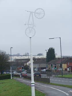
I was walking near the MOD site a couple of days ago and noticed these. The first is a sort of symbolic BSO, presumably to indicate where the cycle path is. I’m sure that it’s only appeared recently; maybe the last couple of months or so. It’s at the top of the bit of shared-use path the goes from the McDonalds bus stop and the retail park entrance. I've not noticed them anywhere else, but I normally ride on the roads rather than the cycle paths. Are there more of these dotted along the north Bristol / South Gloucestershire cycle paths?

20110219 010.jpg

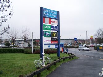
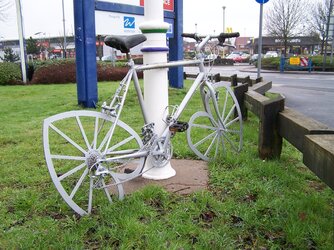
At the other end of that bit of path, at the entrance to the retail park, there is a bike chained to the sign board. I don’t know if it’s a ghost bike, valentine bike, cycle art or what. Does anyone know the story behind this?

20110219 004.jpg

20110219 006.jpg

Stargazer
 
OP
OP
summerdays

summerdays

Cycling in the sun
Location
Bristol
I'll be along that road tomorrow ... but I'm pretty certain they must be new. No idea about the valentines bike!!
 

mgarl10024

Über Member
Location
Bristol
There are a few more of these along Bradley Stoke Way - a similar Valentines Bike is also there, and a man in a wheel by the Bradley Stoke Leisure Centre.

I was speaking with someone from the South Glos Cycle Forum recently who asked if I'd noticed them. They've gone up in the last few weeks and were apparently a project with the local community, where I think they were designed by local school children.
 

darthpaul

Well-Known Member
Location
Bristol
The man in the wheel by Bradley Stoke Leisure Centre was designed by a pupil at the school I work in. Unfortunately it was stolen 2 days after it was put there, apparently the council used normal cement that can take 3 days to fully set and it was stolen overnight on day 2. Presumably because of the scrap metal value :sad: It cost £2000 to make that sculpture I am reliably told and it was gone in 48 hours.
 

mgarl10024

Über Member
Location
Bristol
It cost £2000 to make that sculpture I am reliably told and it was gone in 48 hours.

Amazing.

Being perhaps a little bah-humbug, at those prices, I would question the value for money.
I recently had cause to ring the council (http://www.cyclechat...yclist-barrier/) about a barrier that prevented joining together two great routes, and was told (in short) that they had spent a lot of money putting the routes in and now needed to get them all connected up, however funding may be an issue.
I'd perhaps suggest that spending £2k per sculpture when the routes aren't connected up correctly was perhaps not a wise prioritisation of limited funds? ("Look at my Farrari, she cost a fortune, but I haven't yet spent the £2k laying the concrete ramp so she can get out of the garage....").

Perhaps there's a community engagement angle here that I'm not fully appreciating.

MG
 
Top Bottom