
You are using an out of date browser. It may not display this or other websites correctly.
You should upgrade or use an alternative browser.
You should upgrade or use an alternative browser.
Devon to Monaco
- Thread starter beermonster
- Start date
Page may contain affiliate links. Please see terms for details.
OP
OP
beermonster
Über Member
- Location
- Teignmouth,Devon
Hi, we’ll be on road bikes as we will have support vehicle. 90 miles a day is do-able with a group of 7+ . Would be nice to do it over a longer period but don’t think the boss will be happy1,000 miles in 12 days ?
If it was me I'd allow a month on a touring bike
We did a flat route from Nice to Bordeaux, about 600 miles, it took 14 riding days.
briantrumpet
Legendary Member
- Location
- Devon & Die
For a Paris to Rome I did with five other friends in 2013, we covered the 1050 miles in 11 days, with a support vehicle leaving us travelling light each day. It's do-able if you're fit, and the weather plays ball.Thanks for that. It may be prudent to add another day as we plan it. There are 7 of us doing it at the mo which may increase so a bit of slip streaming may be in order!
Ah, a support vehicle makes all the difference in the world :-) It still won't be easy but it's definitely doable.We plan to have support to avoid carrying stuff and a couple of us have done London to Paris so think 100 miles a day is doable with a day off half way down.
A mix of air bnb and camping will probably be the way to go.
I know Monaco and that area very well and a lap of the circuit is a good call!
The finish line will be the ‘Ship and Castle’ English pub on Port Fontvielle :^)
Bon courage!
OP
OP
beermonster
Über Member
- Location
- Teignmouth,Devon
So an update on our Tour De France!
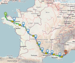
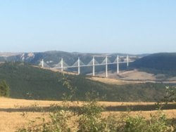
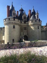
A route was planned using cycle.travel from Exeter to Monaco via the Plymouth/Roscoff ferry. 10days of cycling (a rest day at halfway point) 1016 miles and 64,000ft of climbing in total. On the whole cycle.travel was a good tool to plan a long distance route though at times you were literally taken off a road taken around some houses and brought back onto the same road which was frustrating! We found a lot of the main roads in the north were pretty much deserted even in August so just stayed on the larger roads to eat up the miles. Cycle.travel was great for checking the route chosen using the street view link, though on some minor roads the google car hadn’t made the trip and so had to gamble on the condition of the surface which found us cycling over stony farm tracks on occasions. We were able to plan a route to take some in some stunning scenery including numerous bridges/dams, major rivers and chateaux. As a comparison one of the team felt that on the final day we could cut 10 miles and lots of climbing off our planned route by sticking the start and finish points into google maps and clicking on cycle route! Unfortunately a 20km section through the hills were for mtb exclusively and we found to our cost that road bikes on rock and loose dirt weren’t compatible. We found the days were longer then anticipated due to the up and down of the terrain meaning we couldn’t get a rhythm going for large parts. French drivers were with only a couple of exceptions patient and always indicated and gave loads of space when overtaking and then again as they returned back again such a contrast to this country. Would I recommend the trip? Absolutely it was an incredible achievement and the best way to see a country. Would I do it again? Nah...
A route was planned using cycle.travel from Exeter to Monaco via the Plymouth/Roscoff ferry. 10days of cycling (a rest day at halfway point) 1016 miles and 64,000ft of climbing in total. On the whole cycle.travel was a good tool to plan a long distance route though at times you were literally taken off a road taken around some houses and brought back onto the same road which was frustrating! We found a lot of the main roads in the north were pretty much deserted even in August so just stayed on the larger roads to eat up the miles. Cycle.travel was great for checking the route chosen using the street view link, though on some minor roads the google car hadn’t made the trip and so had to gamble on the condition of the surface which found us cycling over stony farm tracks on occasions. We were able to plan a route to take some in some stunning scenery including numerous bridges/dams, major rivers and chateaux. As a comparison one of the team felt that on the final day we could cut 10 miles and lots of climbing off our planned route by sticking the start and finish points into google maps and clicking on cycle route! Unfortunately a 20km section through the hills were for mtb exclusively and we found to our cost that road bikes on rock and loose dirt weren’t compatible. We found the days were longer then anticipated due to the up and down of the terrain meaning we couldn’t get a rhythm going for large parts. French drivers were with only a couple of exceptions patient and always indicated and gave loads of space when overtaking and then again as they returned back again such a contrast to this country. Would I recommend the trip? Absolutely it was an incredible achievement and the best way to see a country. Would I do it again? Nah...
Attachments
Last edited:
OP
OP
beermonster
Über Member
- Location
- Teignmouth,Devon
Yes we did as we wanted to stick to the roads to get the miles done. The cycle lanes we saw were very hit and miss. Up north they were pretty good but surfaces changed. Section at the end from Antibes to Nice was excellent but in between they appeared and disappeared without warning and no signage.Did you use the 'paved only' option when you were plotting your route?
Thanks
Richard Fairhurst
Guru
- Location
- Charlbury, the Cotswolds
So an update on our Tour De France!
A route was planned using cycle.travel from Exeter to Monaco via the Plymouth/Roscoff ferry. 10days of cycling (a rest day at halfway point) 1016 miles and 64,000ft of climbing in total. On the whole cycle.travel was a good tool to plan a long distance route though at times you were literally taken off a road taken around some houses and brought back onto the same road which was frustrating!
Really pleased cycle.travel found you a good route! If you have any examples of the round-the-houses routes that'd be great - it's a difficult issue to solve (for boring algorithmic reasons), but it is something I'm looking at so test cases are really helpful.