flood alerts: whose flooded out? we are in Rossendale

Page may contain affiliate links. Please see terms for details.

AndyRM

XOXO
Location
North Shields
Looked pretty awful on the news. Hope those affected get sorted.

I was riding back from Tynemouth at about 3 yesterday. Got caught in what I can only describe as a monsoon. Turned the road into a river causing me to miss a hole in the road: bang. Double puncture and a long walk home. Not great.
 

ColinJ

Puzzle game procrastinator!
I just went for a stroll around the town centre. The library is shut due to flood damage and I spotted some more areas of dug-up pavement with emergency electricity cable repairs. I saw lots and lots of Dyno-Rod and plumbers' vans parked outside town centre houses and shops. Lots of mess everywhere. I went to use the Natwest cash machine on the main road and it was out of action. I don't think it was due to the recent technical problems - it had a muddy tide-mark across it at my chest height, showing that the flood waters were at least 4 feet deep there!

I'm surprised by how quickly the water levels went down again. Between 8:00 pm Friday and 04:30 Saturday, most of the water had come and gone.
 

Linford

Guest
I just went for a stroll around the town centre. The library is shut due to flood damage and I spotted some more areas of dug-up pavement with emergency electricity cable repairs. I saw lots and lots of Dyno-Rod and plumbers' vans parked outside town centre houses and shops. Lots of mess everywhere. I went to use the Natwest cash machine on the main road and it was out of action. I don't think it was due to the recent technical problems - it had a muddy tide-mark across it at my chest height, showing that the flood waters were at least 4 feet deep there!

I'm surprised by how quickly the water levels went down again. Between 8:00 pm Friday and 04:30 Saturday, most of the water had come and gone.

Isn't it quite shocking. The good thing is that in that case it is flash flooding and unlikely to be repeated for a good time. The bad thing is obviously that it has made a mess.

When we had that, there were lines of cars abandoned on the apex of the roads in the middle of nowhere. It was very weird to happen across it.
 

ColinJ

Puzzle game procrastinator!
The good thing is that in that case it is flash flooding and unlikely to be repeated for a good time.
Unfortunately, that isn't true - in recent years, for example, we've had flooding in 2000, 2006 and 2008!

Because of the shape of the valley, the flooding problems tend to be concentrated in certain areas, but those are getting hit time after time.

I do think that more could be done to try and protect vulnerable properties - dumping a pile of sandbags in front of a door surely isn't the best way of keeping water out?
 

Globalti

Legendary Member
The trouble with old Victorian properties would be that even if you blocked the door, water would find its way up through the floors.

I can't help wondering why people actually built so close to the river in places like HB, or when they did, why they didn't build higher. Could it be because flash flooding never happened before tarmac roads, car parks and buildings with huge areas of roof? Or could it be that in old times houses and shops had little furniture and no fitted carpets and the occasional flood did no lasting damage? Did people actually live alongside the river or would all the riverside buildings have been workshops and pubs where water didn't matter?
 

Linford

Guest
The trouble with old Victorian properties would be that even if you blocked the door, water would find its way up through the floors.

I can't help wondering why people actually built so close to the river in places like HB, or when they did, why they didn't build higher. Could it be because flash flooding never happened before tarmac roads, car parks and buildings with huge areas of roof? Or could it be that in old times houses and shops had little furniture and no fitted carpets and the occasional flood did no lasting damage? Did people actually live alongside the river or would all the riverside buildings have been workshops and pubs where water didn't matter?

I would have said it was more down to sewage disposal where they would either have to have their own cess pit or be near a running water course to flush it away into the nearest river
 

Globalti

Legendary Member
Colin will be along soon but my understanding is that Hebden Bridge started as just that; a bridge over the river for the main packhorse trunk route to the wool market at Halifax. Being a natural stopping point it wouldn't have been long before inns followed and then the new manufactories, which would have been beside the river for the water and the power. That's what makes me think all the riverside buildings would have been industrial or commercial, not the comfortably furnished and carpeted dwellings, cafes, pubs and shops we have now.
 

ColinJ

Puzzle game procrastinator!
Colin will be along soon but my understanding is that Hebden Bridge started as just that; a bridge over the river for the main packhorse trunk route to the wool market at Halifax.
That's true. The little cobbled packhorse bridge over Hebden Water is a replacement for the original medieval bridge.

winter_ducks_old_packhorse_bridge.jpg


hebden-old-bridge-sign.jpg


I read that the valley used to be very swampy so the packhorse trails stayed high where possible.

The While Lion Hotel is an old coaching inn built in 1657. I would guess that the packhorses were brought though Midgley and Old Town, down to the White Lion. From there they would cross the old bridge and head up the Buttress to Heptonstall. (Or make the journey in the opposite direction towards Halifax.)

Being a natural stopping point it wouldn't have been long before inns followed and then the new manufactories, which would have been beside the river for the water and the power. That's what makes me think all the riverside buildings would have been industrial or commercial, not the comfortably furnished and carpeted dwellings, cafes, pubs and shops we have now.
Most of Hebden Bridge was built surprisingly recently! My house is on a little cobbled back street but it wasn't built until 1888, about the time that many buildings in the town were. There certainly weren't a lot of buildings here before the start of the 19th century.

By contrast, Heptonstall village (on a hill overlooking Hebden Bridge) has many 500 year old buildings.

The sudden expansion of Hebden Bridge in the 19th century was due to the construction of many water-powered mills. If you go for a coffee in the cafe at 'Innovation', take a look at the posters on the walls depicting the history of the local mills. Many of those mills no longer exist.

Later, steam power was used. At one point there were supposed to be about 500 mill chimneys in the Calder Valley and the air pollution was horrendous. Housewives would hang out their washing to dry, then the wind direction would change and would cover the washing with smuts.

I read that Hebden Bridge was considered such a horrible place then that misbehaving children were threatened with being sent here! "Get thee t'Hebden Bridge!"

I just discovered what used to be on the Heptonstall side of the old bridge - Buttress Brink!

"Most problematical of all was Buttress Brink, where occupants had to walk through a gloomy ground floor tunnel still lit by gas lamps, climb steep steps set into an almost vertical hillside, then cross bridges spanning the gaps between hillside and property. Needless to say the homes within boasted no modern amenities such as bathrooms and toilets; the kitchens, small and cramped, had only a single cold water tap over a stone sink."

There is a big picture of Buttress Brink here, and it includes the original Hole in the Wall Inn.
 

Svendo

Guru
Location
Walsden
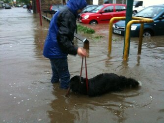
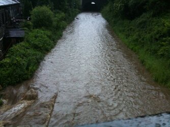
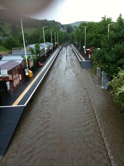
Lots of places along the valley were built up the sides, e.g. Luddenden and Sowerby, and only in the 19thC were substantial development of the valley floor made, Luddenden Foot and Sowerby Bridge, apparently due to industry and the canal and later railway. I'm now in Walsden and got some pictures of the flooding near us. 031.JPG , 032.JPG , 034.JPG . That's SWMBO and Daisy Dog on the road near Grand Ma Pollards. Nearby it was flowing enough to knock you off your feet. second two are each way from the foot bridge at Walsden Station. On the middle one note the speed the water is flowing off the line at the bottom left, yet the water was still rising at this point! My actual House is on the valley side, and not in the path of run off, so 'I'm all right Jack'.
 

dan_bo

How much does it cost to Oldham?

Globalti

Legendary Member
I saw that back in 2005 near Clitheroe; long ribbons of tarmac had been lifted cleanly from road strip repairs and carried many yards down the hill and dumped in the road. Amazing.
 

Svendo

Guru
Location
Walsden
Nice read cheers GTi. I rode over from bacup-walsden on sunday- the road in large parts was littered with rubble washed onto the road, and there were sections of tarmac torn up by the floodwaters. Never seen that before!
Saw that myself too yesterday. Another reason why chip & seal is a false economy.
On pack horse routes, oppostite my new house are Watty Lane and Naze Road, which go almost straight up the 'shoulders' of the hills either side of Bacup Road at Walsden. They were apparently part of a salt route originally. The first toll road road in the valley was on the sides rather than the bottom, Hollins Road is part of it, and there's a Toll House cottage a few doors down from me.
 

Globalti

Legendary Member
The toll houses were built to extract revenue from users of the new turnpike roads, which were generally well engineered for use by wagons. Many of them are now our old trunk routes.
 
Top Bottom