CAESAR AVGVSTVS
Well-Known Member
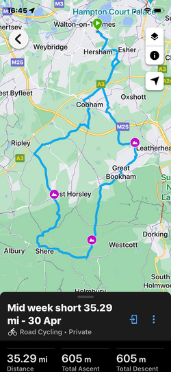
Yesterday I mapped out a short ride for midweek use (36 miles). I know one hill very well, it’s just over a mile long and goes up to 12%. Sure I get tired but a nice downhill to recover. However, me being adventurous or an idiot I put a second hill into the ride, slightly shorter and my garmin said it was classed as cat 4 (easy).
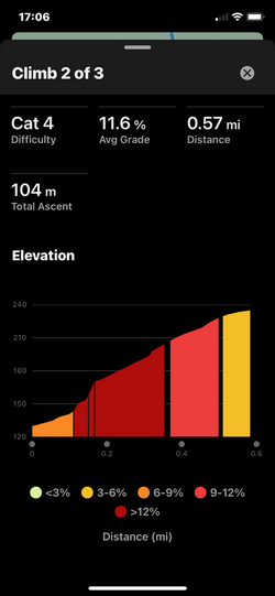
I turned left onto the new hill I’ve never been up before, the first thing I noticed was the sign with 28% on it 🤬. I was in the highest gear I had and even that was not enough. I was rapidly struggling to get that oxygen into my lungs. I stopped half way up for around a minute to get my breath back. Then it was all the way to the top and again struggling to breath 🤣
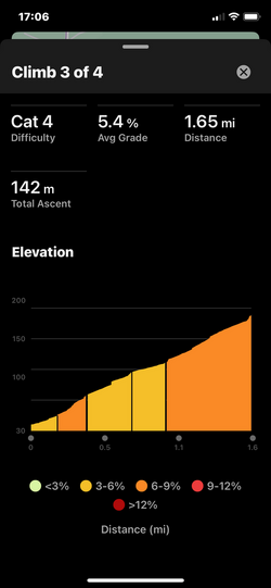
Doing some research it seams distance defines what cat a hill is. So when mapping out a ride, take Garmins cat hills with a pinch of salt 😂
I turned left onto the new hill I’ve never been up before, the first thing I noticed was the sign with 28% on it 🤬. I was in the highest gear I had and even that was not enough. I was rapidly struggling to get that oxygen into my lungs. I stopped half way up for around a minute to get my breath back. Then it was all the way to the top and again struggling to breath 🤣
Doing some research it seams distance defines what cat a hill is. So when mapping out a ride, take Garmins cat hills with a pinch of salt 😂