Strava/Garmin elevation discrepancy

Page may contain affiliate links. Please see terms for details.

livpoksoc

Guru
Location
Basingstoke
I posted another thread a few weeks back as I had a route file on my Garmin that showed an elevation as a series of spikes, which obviously was wrong and the curve was a lot smoother.

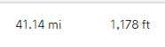
Today however I went out for a ride on a route I drew on Strava, with no obvious issues on the route profile. It was predicted to have 1800ft of climbing over 41 miles - on both Strava and the Garmin. 15 miles from home I'm half panicking thinking I've got 66% of the climbing to do as I'd only covered 400ft on my home screen.

When I got home both Garmin and Strava said I'd covered 1100ft~ of climbs. I have redrawn the route again tonight on Strava to check in case I've missed something, but no - it comes up with the same predicted elevation. I'm just so confused how it can be so out with no obvious errors on the profile.

TIA in case anyone knows how to fix this so I can manage my rides a bit better and avoid overly holding back on the way out.
 

Attachments

  • Elevation discr 1.PNG
    Elevation discr 1.PNG
    1.6 KB · Views: 5
  • Elevation discr 2.PNG
    Elevation discr 2.PNG
    483 bytes · Views: 4

andrew_s

Legendary Member
Location
Gloucester
Climbing figures are a can of worms, and you are on to a loser trying to get different systems to agree.

First off, assuming that you know the true height of the ground in complete detail, how do you define what constitutes climbing?
If you decide that 10 m of height gain constitutes a climb, and ignore everything smaller as being mere slight undulations that you'd not notice on the road, you get one figure. Reduce the minimum climb to one metre, and you'll get a bigger figure (by some margin). Reduce it to 10 cm, and every sleeping policeman counts as climbing and adds in to the total. By this stage your climbing could easily be double the climbing using the 10 m minimum climb.

The next problem is where your height figures come from.
There are 3 main sources - GPS, barometric, or DTM (digital terrain model). Each of these is subject to (different) inaccuracies, and each system using one may have different views on what's climbing and what's noise.

In your case, the figures you get when you plot a ride beforehand come from a DTM.
This divides the world up into a set of squares, typically 30 m or 50 m in size, and assigns a height to each. The climbing figures come from looking at the heights of the squares your route passes through, and adding up the differences.
Different systems may do this differently, so one could just use the current square, another could use the current square but smooth the resulting height graph before using it, and another could look at several nearby squares, effectively treating them as spot heights at the square's centre.

During your ride, heights are taken by the GPS. These may be either heights measured using GPS satellites, or heights measured using a barometric altimeter in the GPS unit. These heights will be what's displayed on the GPS as you ride, and are what it uses to calculate the current climbing total as you ride along.
Some models GPS have a barometric altimeter, some don't, but if there is one, the GPS will usually use barometric heights in preference to the satellite heights.

When you load your ride to Strava, or wherever, both the DTM heights and those recorded by the GPS are available.
I don't do Strava, but from what I hear, if your GPS model is on Strava's list as having a barometric altimeter (eg Edge 1030) Strava will use the GPS unit's heights, and if it's not on the list, it will use the DTM heights, even if the GPS unit in question has a barometer (eg Etrex 30).
The DTM climbing will differ from the pre-ride climbing because the ridden track doesn't exactly match the drawn track.

Personally, if I want a definitive climbing figure for a route, I do a contour count on a 1:50,000 OS map. It takes work, but has the advantage that if someone else does a contour count for the same route at some other time, we get the same answer.
 
Last edited:
OP
OP
livpoksoc

livpoksoc

Guru
Location
Basingstoke
Climbing figures are a can of worms, and you are on to a loser trying to get different systems to agree.

First off, assuming that you know the true height of the ground in complete detail, how do you define what constitutes climbing?
If you decide that 10 m of height gain constitutes a climb, and ignore everything smaller as being mere slight undulations that you'd not notice on the road, you get one figure. Reduce the minimum climb to one metre, and you'll get a bigger figure (by some margin). Reduce it to 10 cm, and every sleeping policeman counts as climbing and adds in to the total. By this stage your climbing could easily be double the climbing using the 10 m minimum climb.

The next problem is where your height figures come from.
There are 3 main sources - GPS, barometric, or DTM (digital terrain model). Each of these is subject to (different) inaccuracies, and each system using one may have different views on what's climbing and what's noise.

In your case, the figures you get when you plot a ride beforehand come from a DTM.
This divides the world up into a set of squares, typically 30 m or 50 m in size, and assigns a height to each. The climbing figures come from looking at the heights of the squares your route passes through, and adding up the differences.
Different systems may do this differently, so one could just use the current square, another could use the current square but smooth the resulting height graph before using it, and another could look at several nearby squares, effectively treating them as spot heights at the square's centre.

During your ride, heights are taken by the GPS. These may be either heights measured using GPS satellites, or heights measured using a barometric altimeter in the GPS unit. These heights will be what's displayed on the GPS as you ride, and are what it uses to calculate the current climbing total as you ride along.
Some models GPS have a barometric altimeter, some don't, but if there is one, the GPS will usually use barometric heights in preference to the satellite heights.

When you load your ride to Strava, or wherever, both the DTM heights and those recorded by the GPS are available.
I don't do Strava, but from what I hear, if your GPS model is on Strava's list as having a barometric altimeter (eg Edge 1030) Strava will use the GPS unit's heights, and if it's not on the list, it will use the DTM heights, even if the GPS unit in question has a barometer (eg Etrex 30).
The DTM climbing will differ from the pre-ride climbing because the ridden track doesn't exactly match the drawn track.

Personally, if I want a definitive climbing figure for a route, I do a contour count on a 1:50,000 OS map. It takes work, but has the advantage that if someone else does a contour count for the same route at some other time, we get the same answer.
Thanks - genuinely for the insight. I suppose what I want to know is what is the best/most accurate way to plot a route that aligns with my Garmin's recording.

Today I got a hunch there was an element of discrepancy as I knew roughly which route home, but just want a bit more accuracy for new routes that I don't know.
 

Tribansman

Veteran
Climbing figures are a can of worms, and you are on to a loser trying to get different systems to agree.

First off, assuming that you know the true height of the ground in complete detail, how do you define what constitutes climbing?
If you decide that 10 m of height gain constitutes a climb, and ignore everything smaller as being mere slight undulations that you'd not notice on the road, you get one figure. Reduce the minimum climb to one metre, and you'll get a bigger figure (by some margin). Reduce it to 10 cm, and every sleeping policeman counts as climbing and adds in to the total. By this stage your climbing could easily be double the climbing using the 10 m minimum climb.

The next problem is where your height figures come from.
There are 3 main sources - GPS, barometric, or DTM (digital terrain model). Each of these is subject to (different) inaccuracies, and each system using one may have different views on what's climbing and what's noise.

In your case, the figures you get when you plot a ride beforehand come from a DTM.
This divides the world up into a set of squares, typically 30 m or 50 m in size, and assigns a height to each. The climbing figures come from looking at the heights of the squares your route passes through, and adding up the differences.
Different systems may do this differently, so one could just use the current square, another could use the current square but smooth the resulting height graph before using it, and another could look at several nearby squares, effectively treating them as spot heights at the square's centre.

During your ride, heights are taken by the GPS. These may be either heights measured using GPS satellites, or heights measured using a barometric altimeter in the GPS unit. These heights will be what's displayed on the GPS as you ride, and are what it uses to calculate the current climbing total as you ride along.
Some models GPS have a barometric altimeter, some don't, but if there is one, the GPS will usually use barometric heights in preference to the satellite heights.

When you load your ride to Strava, or wherever, both the DTM heights and those recorded by the GPS are available.
I don't do Strava, but from what I hear, if your GPS model is on Strava's list as having a barometric altimeter (eg Edge 1030) Strava will use the GPS unit's heights, and if it's not on the list, it will use the DTM heights, even if the GPS unit in question has a barometer (eg Etrex 30).
The DTM climbing will differ from the pre-ride climbing because the ridden track doesn't exactly match the drawn track.

Personally, if I want a definitive climbing figure for a route, I do a contour count on a 1:50,000 OS map. It takes work, but has the advantage that if someone else does a contour count for the same route at some other time, we get the same answer.

This is pretty comprehensive but I'd just add one thing: was it raining on the rides where you lost elevation on the Garmin? I've had that issue before, as the water blocks the altimeter (I had an Edge 520).

If that was the case, go to the ride on strava on a desktop/laptop and click the 'correct elevation' link beneath the climbing figure in the ride summary. That will then apply the DTM figure. Not helpful for your in-ride management of effort, only if it's important to you to have it logged more accurately...
 
This is pretty comprehensive but I'd just add one thing: was it raining on the rides where you lost elevation on the Garmin? I've had that issue before, as the water blocks the altimeter (I had an Edge 520).

I thought this was a result of changes in barometric pressure due to the changing weather. I’ve never noticed big discrepancies if it’s raining throughout a ride. (Edge 520 too)
 
OP
OP
livpoksoc

livpoksoc

Guru
Location
Basingstoke
This is pretty comprehensive but I'd just add one thing: was it raining on the rides where you lost elevation on the Garmin? I've had that issue before, as the water blocks the altimeter (I had an Edge 520).

If that was the case, go to the ride on strava on a desktop/laptop and click the 'correct elevation' link beneath the climbing figure in the ride summary. That will then apply the DTM figure. Not helpful for your in-ride management of effort, only if it's important to you to have it logged more accurately...
I thought this was a result of changes in barometric pressure due to the changing weather. I’ve never noticed big discrepancies if it’s raining throughout a ride. (Edge 520 too)

Thanks - Edge 520 too.

It was yesterday first thing with thick fog, so that might be it. It wasn't a particularly lumpy route with no 'big climbs' for round here.
 
Climbing figures are a can of worms, and you are on to a loser trying to get different systems to agree.

First off, assuming that you know the true height of the ground in complete detail, how do you define what constitutes climbing?
If you decide that 10 m of height gain constitutes a climb, and ignore everything smaller as being mere slight undulations that you'd not notice on the road, you get one figure. Reduce the minimum climb to one metre, and you'll get a bigger figure (by some margin). Reduce it to 10 cm, and every sleeping policeman counts as climbing and adds in to the total. By this stage your climbing could easily be double the climbing using the 10 m minimum climb.

The next problem is where your height figures come from.
There are 3 main sources - GPS, barometric, or DTM (digital terrain model). Each of these is subject to (different) inaccuracies, and each system using one may have different views on what's climbing and what's noise.

In your case, the figures you get when you plot a ride beforehand come from a DTM.
This divides the world up into a set of squares, typically 30 m or 50 m in size, and assigns a height to each. The climbing figures come from looking at the heights of the squares your route passes through, and adding up the differences.
Different systems may do this differently, so one could just use the current square, another could use the current square but smooth the resulting height graph before using it, and another could look at several nearby squares, effectively treating them as spot heights at the square's centre.

During your ride, heights are taken by the GPS. These may be either heights measured using GPS satellites, or heights measured using a barometric altimeter in the GPS unit. These heights will be what's displayed on the GPS as you ride, and are what it uses to calculate the current climbing total as you ride along.
Some models GPS have a barometric altimeter, some don't, but if there is one, the GPS will usually use barometric heights in preference to the satellite heights.

When you load your ride to Strava, or wherever, both the DTM heights and those recorded by the GPS are available.
I don't do Strava, but from what I hear, if your GPS model is on Strava's list as having a barometric altimeter (eg Edge 1030) Strava will use the GPS unit's heights, and if it's not on the list, it will use the DTM heights, even if the GPS unit in question has a barometer (eg Etrex 30).
The DTM climbing will differ from the pre-ride climbing because the ridden track doesn't exactly match the drawn track.

Personally, if I want a definitive climbing figure for a route, I do a contour count on a 1:50,000 OS map. It takes work, but has the advantage that if someone else does a contour count for the same route at some other time, we get the same answer.
This is extremely comprehensive.

I will add one thing. GPS is not 100% accurate, and tracks tend to deviate slightly from the general path (but rarely by more than a few metres)
This is completely fine for navigation and accurate enough for most uses, but if you ride in an area with steep hills, two things happen:

1) accuracy is reduced because less of the sky is visible, so your GPS receives signals from fewer satellites, not to mention that the signal can bounce
2) a small discrepancy in your GPS can easily make it seem that your track is leaping up the side of the hill then back down or vice versa, which completely wrecks DTM-based elevation calculations.

My worst ever ride for this added probably over 8000ft of climbing to my actual elevation gain, but I didn't have the heart to correct it :whistle:
 

Ajax Bay

Guru
Location
East Devon
what I want to know is what is the best/most accurate way to plot a route [which produces a climb figure] that aligns with my Garmin's [climb] recording.
You may wish to consider if this is actually the exam question.
The climbing figure your Garmin produces is affected by loads of stuff already well described above by @andrew_s et al. You will not get planning tools that can 'align' with a reading that you don't know till you've ridden the route on a day in varying barometric conditions and satellite visibility.
I use RwGPS for all my planning (with some help from other sites/apps) and that gives me the climbing figure I use to record my rides. On an Edge500, the climb is always more (10+% more). I upload the Garmin fit file to RwGPS and that gives me a (revised) climbing figure consistent will all my other rides. That revised climbing figure is calculated by RwGPS based on the route detail and its topographic(?) algorithm, not any stuff from the ride file. I have done route checks on RwGPS climbing and OS 50 thou map contour climbing and they are normally pretty close.
So my recommendation is: ignore the Garmin (and any Strava type downloads) for your climb data.
 

Tribansman

Veteran
I thought this was a result of changes in barometric pressure due to the changing weather. I’ve never noticed big discrepancies if it’s raining throughout a ride. (Edge 520 too)

Yeah, definitely a blockage...for me anyway. The worst i had was on a hill repeats everesting training ride, so I knew what the elevation should be. Torrential rain most of the ride and only 1,800 ft of elevation recorded/displayed (when it should have been c. 15,000!!)
 

iluvmybike

Über Member
Every route planner will calculate the height differently depending on the algorithm used. Most of them seem to under-read what the Garmin readout arrives at. My hubby and I have identical Garmins - we often get different height readings on same ride as well - prob due to us having slightly different settings
 

wajc

Veteran

TheDoctor

Europe Endless
Moderator
Location
The TerrorVortex
Altitude is tricky. Over the years, Luxembourg has been mapped using barometry, surveying, and GPS.
That's why there's two towers and a plaque, all showing the highest point and all some distance apart from each other...
At least the highest point in the Netherlands is easy to find. It's in the Caribbean.
 
Top Bottom