The CC Trig Point bagger thread, now incorporating other interesting geographs

Page may contain affiliate links. Please see terms for details.

Bobby Mhor

Wasn't born to follow
Location
Behind You
B789 nr Langbank..
I've looked for this before...
slowly disappearing.
NS nr Langbank, B789, Wall.jpg
 
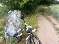
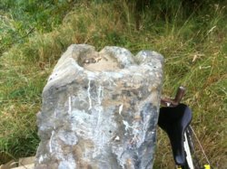
'Plague Stone'
As some perceive it to be

I'd think of it more of a boundary stone/gate-post that was on the route to a 'gentlemans country residence' that was probably accessed via that route (as well as 3 others, with gate-houses)

It's on a bridleway, from Patience Lane (Lee Brigg) to NewLands Estate

36634362_10214979663957346_5359049437903585280_n.jpg 36649400_10214979663677339_8687640304800497664_n.jpg

http://www.geograph.org.uk/photo/2034481
 

Tim Hall

Guest
Location
Crawley
As mentioned by @User13710 in another thread, Saturday saw me and two other fine people out for a ride. The primary objective was this:
6asOHWxCAGzmBeDTN5QoAg2QEIcZ5Db_-vn3jxP5hI_jVm9l3gbIkAWv_2xAzJv7Yzrx0jzy7__zmRXKLd0=w401-h301-no.jpg

Which sits on the entrance to an ROC bunker at Cuckfield. More to the point, they were having an open day, where the bunker is re fitted with all its cold war gubbins and a very knowledgeable bloke enthused about it.
While a lightly injured member of our party stayed aloft, two of us went down the ladder:
wJo80hPIanDIOSjQkGzy6sPkntsI4C3nZTTqP82vpK5gs-dsRmxx0enFFzmwGJCinTYYADSF10aLtBSVlA=w1036-h777-no.jpg

That white dial on the right is a blast wave measuring gadget.
Uwgm1RhLXa6vvx6kOlIpeFCBVrO9_XuSDvIko_6dBlQ8e7yMP8zZMtMvmMwKXuL23EpPw7mcoBLHgLaHeWE=w583-h777-no.jpg

Looking back up the ladder. Fortunately, despite an alarm of fallout detected going off, all was well and we emerged into the sunshine.
_Yxh04azkEQ3m_CG2B-8R-WpzP_Bb9AB9xk-3TrTcP4ikFq2m4FNcz412msZsiZp0dQsBdq7-iN-qr_jc4=w1036-h777-no.jpg

This is the insides of the altitude and bearing measuring gadget. It's four pinhole cameras with, I guess, photo sensitive paper, marked of in azimuth and elevation. There hasn't been a bomb, that's the trace from the sun. More pics here.

PS, do we need an Urban Exploration thread?
 

biggs682

Touch it up and ride it
Location
Northamptonshire
@Tim Hall very good pictures i bet those steps have never been so busy
 

Tim Hall

Guest
Location
Crawley
While we consider the need for an Urban Exploration thread, see what else I did: @User13710 and Adrian peeled off after lunch. It was very very hot and there was a sporting event on the TV but I continued over to Shipley to look at the Zero station bunker. They were "stay behind" bunkers in the event of invasion in WWII. This one has mostly collapsed but parts are still visible:
SkRV5kd4gJOcaxXznHmhnBGA8GcIfQEcdze4qow_SI4T7-DJ24Ica3RwEuHdHullFMFdWDBZMdIm1lfm7mg=w583-h777-no.jpg


The groove in the bark of this oak tree was where the radio antenna cable was hidden.
KkpOfk_VJunbk2e9nGc9dVdgsPYLpNFFTNaHgYc12BzaM6yaEJYXMVEuBKdXxLbm5-filPgyEKlryXHedE=w1036-h777-no.jpg


This pit was one of the two entrances to the bunker. BITD it would have been camouflaged as a badger sett or similar.
lpFHZzOc9sdYwomsWwixFF1lSETdWWT5Fa4buRUdel_JcPxz87vZx6pD_zp3OMAtK_LtPW6-8cW00VnGgk=w1036-h777-no.jpg


After entering the badger sett above you would crawl through a tunnel and emerge here. The bunker itself was a buried prefab Nissen hut type affair, which has since collapsed leaving a hole in the ground. Foolishly I didn't take any pictures of the hole in the ground. My Sinister Agents tell me there's a similar bunker in the grounds of Wakehurst Place, the country branch of Kew Gardens in Ardingly. More about Shipley Zero Station on the SubBrit website here.
 

Tim Hall

Guest
Location
Crawley
Nearly forgot this one.
ibM6vedUtFGQ3cmxlvEY1DEDsCfvYsagbRHtOtyPcK_YPA_o_T1X15yz_q-fqc9VImYvkE-uM0Ez5Pcfko=w1036-h777-no.jpg


On our exit from Crawley we took the NCN 20 through Tilgate Forest for a spot of Comedy Off Roading on Mildly Inappropriate Bikes, then up Parish Lane towards Pease Pottage. On a previous trip I'd spotted a pair of chestnut trees either side of the lane bearing a small plastic plaque, so felt I had to show off point them out to my riding companions. Beneath the leaves you can just make out some names and Clarencourt Cycling Club. A few years ago I did a bit of digging and emailed Clarencourt CC about them. The two chestnut trees in the hedgerows on either side of Parish Lane mark the start line of the old Catford 24 hour time trial and when Micky Ayliffe died in 1978 his his ashes were buried there and the tress planted on top in memoriam. According to his son, he loved long distance time trialing and was second and third in the Catford event in the 1950's. Later when Edie, his widow died, her ashes were scattered there too. Here's a picture of Micky Ayliff on the Clarencourt website. https://www.clarencourt.com/about-clarencourt-cycling-club/over-the-hill-gang-ohg/

Edit: fixed broken link
 
Last edited:

PeteXXX

Cake or ice cream? The choice is endless ...
Location
Hamtun
733CC99C-15A9-4708-98FD-C9C229C3FDF9.jpeg


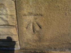
A BM on Castlethorpe church.

18CBFF90-57B8-4B67-9176-5A62D2B40552.jpeg


A BM on Sherington church.

61BEB16B-D539-417C-A3F4-4DC397EAC3DC.jpeg


And a flush Bracket on Winnowing Barn, Sherington.

:smile:

49F8294F-39B0-43EE-98FD-D7F6B6BEDBE4.jpeg


Edit: there’s supposed to be a Trig Point in the middle of this field to the south of Emberton. Possibly removed. It’s on the OS map, but I’ve not had s chance to fire up the database to check yet.
 
Last edited:
Top Bottom