The CC Trig Point bagger thread, now incorporating other interesting geographs

Page may contain affiliate links. Please see terms for details.
All being well.....
(it's already booked/paid-for)

We're meant to be having a tour of Scotland, between Mon 19th & Sat 24th
We're going up as far as Inverness, then down the 'Ness, to Fort William

So there could be a lot to put on here!!

This is the view, for our first night at North Queensferry!!

4461b9c0-e0e0-484f-91f2-2e61d3ea6b79.jpg


Then, I think, it's Inverness (2 nights)
Oban (1night)
Somewhere on Skye, for the 5th
 
The view inside the Queensbury Tunnel, looking towards Halifax. From ground level.
View attachment 519559

im sure i signed a petition about this on one of the change type websites, but you may say different
 
All being well.....
(it's already booked/paid-for)

We're meant to be having a tour of Scotland, between Mon 19th & Sat 24th
We're going up as far as Inverness, then down the 'Ness, to Fort William

So there could be a lot to put on here!!

This is the view, for our first night at North Queensferry!!

View attachment 551367

Then, I think, it's Inverness (2 nights)
Oban (1night)
Somewhere on Skye, for the 5th
now thats a view, brilliant
 
Monday 12th
4.


Howden Lane railway bridge
(off York Road/B1222)
Naburn

For all the world, with the lining, it looks like a narrow-boat on an aquaduct over the road!!

It is (or was!) the East Coast Main Line, in the days it went over the swingbridge at Narburn, then through Selby, via that swingbridge too
Now a cycleway/bridleway/footpath; https://www.sustrans.org.uk/find-a-route-on-the-national-cycle-network/york-to-naburn/

552061


https://www.geograph.org.uk/photo/5070511
 
Last edited:
Monday 12th
6.


Hartleys Bridge
FerryBridge

This carried the 'Great North Road' (later A1) over the River Aire, until it was superceded by the adjacent concrete viaduct in the 60's. which itself is now almost redudant, due to the 'new ' A1 a mile, or so, to the west

At present, it's being inspected/repointed/resurfaced
One of the civil engineers told me that they're even having to remove stalactites from under the bridge, due to minerals leaching out of the stonework

552069


Two of the 'flood-arches' on the west bank
The entire area can be a floodplain
(see bottom, below my links)


552070


The 'Cherry Picker' was being used for under-bridge inspections
552071


John Carr.... Architect
Also responsible for such buildings as Harewood House
552072


Parish boundaries;
FerryBridge..... Brotherton
552073


https://britishlistedbuildings.co.uk/101225759-ferry-bridge-brotherton#.X4Sux-aSnIU
https://www.geograph.org.uk/photo/5271912

From above....
Not my images, but for illustration


Circa 1950
552078


The raised causeway of the 'GNR' can be seen as it heads to Brotherton
In the dual-carriageway days, it headed off slightly, & carried on north past the road shown - that became the southbound 'on' sliproad from the 'Tadcaster TurnPike' (A162)
In this image, the 'GNR' & 'T T' split by the Brotherton Fox pub
552079


The road straight ahead is the original route, as seen above (at top of previous image)
The one to the right is the north-bound 'off-slip' to the 'T T'
Local cyclists may know the area well, as the lane to the left (heading east) goes through Byram & Sutton to Birkin Cafe
552083
 

Mr Celine

Discordian
At the north (Sutherland) end of the bridge at Bonar Bridge is a triangular column with plaques on each side commemorating the first, second and present bridges across the Kyle of Sutherland.
552080


552081


552082


The first bridge was washed away in a flood, the second was dismantled after the current one was constructed.

552084


I thought about extending my loop down to the Cromarty Bridge but the extra 25 miles and the view in front of me made me think it would have been a bridge too far.

552088
 
All being well.....
(it's already booked/paid-for)

We're meant to be having a tour of Scotland, between Mon 19th & Sat 24th
We're going up as far as Inverness, then down the 'Ness, to Fort William

So there could be a lot to put on here!!

This is the view, for our first night at North Queensferry!!

View attachment 551367

Then, I think, it's Inverness (2 nights)
Oban (1night)
Somewhere on Skye, for the 5th

Extra night booked at North Queensferry, so heading up in the morning, not on Monday

I'll see what I can spot:okay:
 
All being well.....
(it's already booked/paid-for)

We're meant to be having a tour of Scotland, between Mon 19th & Sat 24th
We're going up as far as Inverness, then down the 'Ness, to Fort William

So there could be a lot to put on here!!

This is the view, for our first night at North Queensferry!!

View attachment 551367

Then, I think, it's Inverness (2 nights)
Oban (1night)
Somewhere on Skye, for the 5th

Home about 17:00 yesterday with; 1,738.3 miles driven..................

Lots of hopefully interesting photos taken, but with 600+ to look through, & find links for, plus remembering where some were, even....:wacko:
 
Last edited:
Home about 17:00 yesterday with; 1,738.3 miles driven..................
Lots of hopefully interesting photos taken, but with 600+ to look through, & find links for, plus remembering where some were, even....:wacko:

Sorry, I've been a bit tardy:blush::blush:
I'll try to upload a batch over the next couple of days

Here's a starter for........

1.
Sunday 18th
En-route up, we stopped off in Berwick-upon-Tweed

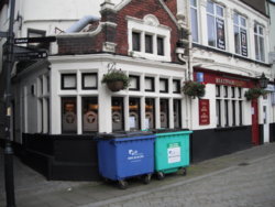
'The Brewers Arms'

MaryGate

What a glorious frontage!!

554848


554850


554849


https://www.geograph.org.uk/photo/6252626
 
Top Bottom