The CC Trig Point bagger thread, now incorporating other interesting geographs

Page may contain affiliate links. Please see terms for details.
Tuesday 2nd
7.

Aire & Calder Navigation Canal
(bottom of) Lock Lane
Lower Altofts
(between Wakefield & Castleford)

The bridge is the M62, between jcts 30 & 31
30 (west) to the left

DSCF6605.JPG


I was on the right-hand bank, as you look at this photograph; https://www.geograph.org.uk/photo/6716572
 
Tuesday 2nd
8.


Foxholes Lock
Aire & Calder Navigation Canal
Foxholes Lane
Altofts


Quite out of the ordinary names....
576682


576681


576683


Both boats would be to the photographers immediate left; https://www.geograph.org.uk/photo/395375

NB;
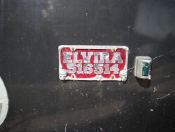
Stanley Ferry Marina, roughly a mile to the south-west has, or had, such names as
'Elvira'
'The Green Man'
 
Thursday 4th
1.


Boat Lane
Lower Mickletown
Methley
(between Castleford & Rothwell)

576988


This was the route to the 'foot-ferry' across the River Aire, to Allerton Bywater
Correspondingly, there is also a Boat Lane, at that side of the river
Plus 'The Boat' pub

https://www.geograph.org.uk/photo/2627941

https://www.geograph.org.uk/photo/5691332

The footpath to the river banking is temporarily closed, due to flooding (& pumping)

576989


576990


Seen here as, Allerton Ferry; https://maps.nls.uk/geo/explore/#zoom=18&lat=53.74094&lon=-1.36838&layers=168&b=1
 
 
With regard to the above, I hope to get to;
An African country
A country on the North Sea coast
A city in Russia
The furthest place you can go/the apocalypse
A road that tells fibs about its length
A waterfall

Oh, & hopefully also a lovely curving railway viaduct, that's now a footpath/bridleway/cycle-route

That's where I have plans to take her.............
 
Last edited:
Top Bottom