The CC Trig Point bagger thread, now incorporating other interesting geographs

Page may contain affiliate links. Please see terms for details.
Sunday 9th
9.

Railway tunnels, & River Colne Aquaduct
'Tunnel End'
Marsden

625679


625678


https://britishlistedbuildings.co.u...-tunnel-portal-colne-valley-ward#.YdsVpNHP3IU
https://britishlistedbuildings.co.uk/101266900-aqueduct-and-weir-colne-valley-ward#.YdsVrtHP3IU

Seen from above; https://www.geograph.org.uk/photo/827009
https://www.geograph.org.uk/photo/3576994

https://www.standedge.co.uk/The-Standedge-Tunnels.html
http://www.forgottenrelics.co.uk/tunnels/standedge.html
 
Last edited:
Sunday 9th
10.

Gods Own County:notworthy:
Grains Bar
Oldham Road/A672

625686


https://www.geograph.org.uk/photo/4387870
 
Sunday 9th
11.

Oxygrain Bridge
A672
This section runs between jct22/M62 & Ripponden (it's the road seen to the north of the M62, where Stotts Hall Farm, stands between the carriageways)

625689


625690


The old Pack-Horse bridge

625691


625688


The 'new' bridge, dates to the 1790s, & 'Turn-PIking'

https://ancientmonuments.uk/104028-oxygrains-packhorse-bridge-rishworth-ripponden#.YdsZ0dHP3IU
https://www.calderdale.gov.uk/envir...ments/monuments-full.jsp?propno=HSK5NQDWL2000

https://www.geograph.org.uk/photo/197415
https://www.geograph.org.uk/photo/1177906
625693
 
Sunday 9th
11.

Boothwood Reservoir Dam
from Moselden Lane (1)
This is the reservoir that can be seen north of the M62, by Stotts Hall Farm, where the carriagways divide, caused by the geology of the area
625696

625697


https://www.geograph.org.uk/photo/4389098
https://www.geograph.org.uk/photo/1160207

http://www.calderdalecompanion.co.uk/ph271.html


1. I followed this lane along, it gets interesting, when it becomes Smithy Lane, after the junction with Withens End Lane
Dropping down to the bottom of the valley, it gets very narrow, with stone setts!
 
Last edited:
Sunday 9th
14.

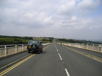
'Scammonden Bridge'
Carrying the A6114/Saddleworth Road, over the M62

The fencing is a lot higher than the last time I drove over it; see thumbnail (July 2005)
There's emergency phones at both ends, but I have no idea if they're direct-dial to 999, or to the Samaritans??

When the bridge opened in 1970. it was the longest single-span non-suspension bridge in the world
It's still the longest concrete arch bridge in the UK

625709


625710

https://en.wikipedia.org/wiki/Scammonden_Bridge

https://www.geograph.org.uk/photo/2048953
https://www.geograph.org.uk/photo/860645
 
Last edited:
Wednesday 12th
2.

'Bankers Draught’
High Street
Normanton

An excellent play on words, as this building was originally the Midland Bank (subsequently the HSBC), after closure as that (1), it was reopened as a bar named the ‘Ole Int Wall’ (2)

626101


https://www.geograph.org.uk/photo/1961432

1. We had 4 other banks in the town!
All went during the fashion for internet banking, driven more by the Banks themselves, that customers?
(or opening hours were reduced, & made unviable, for a lot of account-holders?)
Barclays (now flats)
TSB (empty)
Yorkshire (empty)
Halifax (still open.... for now)

2. March 2016, still with the Midland Logo, but it's the bar


View: https://www.facebook.com/photo/?fbid=10207756767949460&set=a.10206883847206987
 
Last edited:
Last edited:
Last edited:
Friday 21st
5.

Apologies, this ought to have been number 1, but I forgot that daughter took it, & emailed it to me


Timble Beck Bridge
East Street
Leeds

It's on the 'new' road that starts at Smeaton Viaduct & heads to the north of the Aire
East Street continues to come out by the Parish Church, with the other 1/2 of the split joining Marsh Lane, to pass under the railway viaduct

Here's a blast from Leeds forgotten past.
This is the only surviving bridge from the East Street/Timble beck. These metal bridges were made at Steander Foundries on East Street. Steander is a part of old Leeds that has vanished off the map altogether. I think most people would struggle to tell you where it was these days. Steander is a Norse word that means 'A stoney place'

*The eagle eyed can spot this old bridge between some bushes in the middle of this roundabout here*
https://www.instantstreetview.com/@53.793337,-1.530839,290.6h,1.91p,1z,1Ligd6oLeJF3b6c7GHIUbg

627931


https://www.leodis.net/viewimage/71018
https://www.leodis.net/viewimage/71013

View: https://www.facebook.com/photo/?fbid=10203562129746660&set=gm.635176389914135


Then (1950s?) & Now

627932
 
Last edited:

classic33

Leg End Member
Friday 21st
5.

Apologies, this ought to have been number 1, but I forgot that daughter took it, & emailed it to me


Timble Beck Bridge
East Street
Leeds

It's on the 'new' road that starts at Smeaton Viaduct & heads to the north of the Aire
East Street continues to come out by the Parish Church, with the other 1/2 of the split joining Marsh Lane, to pass under the railway viaduct

Here's a blast from Leeds forgotten past.
This is the only surviving bridge from the East Street/Timble beck. These metal bridges were made at Steander Foundries on East Street. Steander is a part of old Leeds that has vanished off the map altogether. I think most people would struggle to tell you where it was these days. Steander is a Norse word that means 'A stoney place'

*The eagle eyed can spot this old bridge between some bushes in the middle of this roundabout here*
https://www.instantstreetview.com/@53.793337,-1.530839,290.6h,1.91p,1z,1Ligd6oLeJF3b6c7GHIUbg

View attachment 627931

https://www.leodis.net/viewimage/71018
https://www.leodis.net/viewimage/71013

View: https://www.facebook.com/photo/?fbid=10203562129746660&set=gm.635176389914135


Then (1950s?) & Now

View attachment 627932

If ever you're in Whitelocks yard, near the top bar, there's a manhole cover made at "Steander Iron Foundry, East Street, Leeds".
 
Top Bottom