
Sea of vapours
Guru
- Location
- Clapham, Yorkshire Dales
May's ride completed on 22nd.
There was one significant road in the North Pennines which I'd not cycled up and this ride was a couple of days earlier to get to a starting point to address that omission (the road from Allendale up to Black Hill, above Nenthead). I'd also not combined three, particular hills in the Pennines in one ride before, or not south to north anyway, so I took the opportunity to do that on the way north on the 22nd. I started off by heading to Tebay and then across the Westmorland Dales via the very pretty Sunbiggin Tarn road to Brough. There's then a big climb up Shot Moss, at about 500m, followed by an excellent, 15km descent to Middleton-in-Teesdale. At this point the hard bit begins.
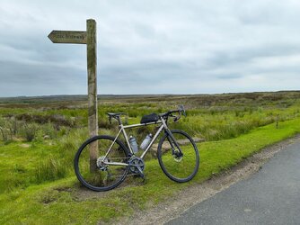
The first hill is variously described as 'Newbiggin Common', 'Swinhope Head', and as 'the gated road from Newbiggin to Westgate'. It takes you from Teesdale to Weardale along a very small road with a few cattle grids, a gate, and some grass in the middle in places and offers excellent views on both sides. It reaches 608m, which is one metre lower than the more well-known Harthope Head road a few kilometres to the west. To me, it's way nicer than that as if usually features no vehicles at all for 11km and the other is a double-width road. It only gets to about 15%, and overall it's mostly 6-7%; it's just long! The image below is about a third of the way up the 350m ascent

After dropping into Westgate, my route went immediately up Peat Hill, which climbs back about 270m, starting at 20%. Annoyingly, there was a lorry blocking the way on the steep bit so I had to get off and walk past it, and then up the next 300m since no way can I get going again on 20%+ gradients. This road then drops down to emerge by Rookhope Arch and the continuation was directly across the road again, and up another steep, short climb, Cuthbert's Hill, onto the moor between Rookhope and Blanchland. This also claims to be 20%, according to the OS, but seems a little easier than Peat Hill (possibly because that's over 20% though!). Again, the views up there are beautiful, assuming you like largely featureless, rolling upland fell, which I do.
After passing through Blanchland, having just missed the shop closing for liquid resupply unfortunately, I had another couple of hours wending my way through the less urban parts of County Durham to reach Blanchland, over many, small undulations. At one point my aversion to cycleways dropped me nearly 100m into a valley, only to ascend it immediately, back to what is actually a perfectly fine, paved section of the C2C near Consett. In retrospect, I shall use that section next time in preference to the 3km up/down road.
A great route; pretty hard in the relative warmth.

There was one significant road in the North Pennines which I'd not cycled up and this ride was a couple of days earlier to get to a starting point to address that omission (the road from Allendale up to Black Hill, above Nenthead). I'd also not combined three, particular hills in the Pennines in one ride before, or not south to north anyway, so I took the opportunity to do that on the way north on the 22nd. I started off by heading to Tebay and then across the Westmorland Dales via the very pretty Sunbiggin Tarn road to Brough. There's then a big climb up Shot Moss, at about 500m, followed by an excellent, 15km descent to Middleton-in-Teesdale. At this point the hard bit begins.
The first hill is variously described as 'Newbiggin Common', 'Swinhope Head', and as 'the gated road from Newbiggin to Westgate'. It takes you from Teesdale to Weardale along a very small road with a few cattle grids, a gate, and some grass in the middle in places and offers excellent views on both sides. It reaches 608m, which is one metre lower than the more well-known Harthope Head road a few kilometres to the west. To me, it's way nicer than that as if usually features no vehicles at all for 11km and the other is a double-width road. It only gets to about 15%, and overall it's mostly 6-7%; it's just long! The image below is about a third of the way up the 350m ascent
After dropping into Westgate, my route went immediately up Peat Hill, which climbs back about 270m, starting at 20%. Annoyingly, there was a lorry blocking the way on the steep bit so I had to get off and walk past it, and then up the next 300m since no way can I get going again on 20%+ gradients. This road then drops down to emerge by Rookhope Arch and the continuation was directly across the road again, and up another steep, short climb, Cuthbert's Hill, onto the moor between Rookhope and Blanchland. This also claims to be 20%, according to the OS, but seems a little easier than Peat Hill (possibly because that's over 20% though!). Again, the views up there are beautiful, assuming you like largely featureless, rolling upland fell, which I do.
After passing through Blanchland, having just missed the shop closing for liquid resupply unfortunately, I had another couple of hours wending my way through the less urban parts of County Durham to reach Blanchland, over many, small undulations. At one point my aversion to cycleways dropped me nearly 100m into a valley, only to ascend it immediately, back to what is actually a perfectly fine, paved section of the C2C near Consett. In retrospect, I shall use that section next time in preference to the 3km up/down road.
A great route; pretty hard in the relative warmth.
Last edited: