Hands up who owns a map?

Page may contain affiliate links. Please see terms for details.

Cubist

Still wavin'
I am an old traditionalist, but I love gadgets, so love to pore over a map and as others have said, "read it like a book." For me a map is a very practical thing, but it is, as others have said, a conveyor of information far and above route-finding. I have very fond memories of sitting in my old cottage with the log fire going, map spread out on the table and a good pot of tea to hand, plotting where I was going to walk the next day. In those days before kids and bikes I was a "comer-in" to this little lump of Yorkshire, having been born and brought up in Warwickshire. The Peaks and South Pennines in particular were favourite holiday destinations for me when I was a teenager and every school holiday a mate and I would plot a week's hostelling in the area, so when circumstances led me to move here there was a blissful feeling of living in a permanent holiday destination. Maps obviously form a huge part of that whole "feeling."

Interesting what others say about Geography. I did it for O and A levels, and had a truly inspirational teacher, Nigel Bates. He could impart a love of the subject like no other, and strangely enough he was a Yorkshireman. A field trip to Settle in about 1980 is one of my most endearing memories, not least because of the visits to Malham Cove and various pots and fosses.

SO now that I live in the Pennines and have rediscovered "roving" by MTB, maps still form a huge part of the equation, but then GPS with its pinpoint accuracy and logging function is a hugely beneficial tool. Internet mapping and logging sites like Mapometer are places I can get lost in but for sheer visceral tugging memories, an OS 2 1/2 inch Outdoor Leisure has it all sewn up.
 

Night Train

Maker of Things
I have dozens of maps, from A-Z maps to OS maps and historic maps. As much as I like using online maps and my SatNav I also have paper maps as they are easier to use when getting an idea of where a place is, the most appropriate routes, and places in the surrounding area.
 

mr_hippo

Living Legend & Old Fart
I gave my collection of OS maps to cycling friends before I came to Thailand but I have found a good series of maps by a company calle ThinkNet. It costs about £6 for a paper map and associated CD ROM!
The CD is zoomable, searchable and bilingual.
If I am going anywhere strange, I zoom in on the area and print a copy in English and on the reverse I print a copy in Thai.
Whilst on the subject of maps, does anyone of more mature years remember two series of maps one was 50 miles around XXX and the other was The Cyclist's map of XXX - l think both were produced by Geographica )or something similar)
 

ColinJ

Puzzle game procrastinator!
1801624 said:
Walking in Corfu would teach anyone who doesn't already to appreciate decent maps
Or cycling there!

I hired a bike to explore the island but could only find a crappy map. I ended up cycling up a road that apparently didn't exist to a village that also apparently didn't exist. I called in a shop there to try and buy a better map but the shopkeeper tried to sell me another copy of the same one. He didn't seem to understand my problem. He didn't speak great English, I don't speak Greek. I pointed at the road, then the map. He shrugged. I waved my hand around at the village, then pointed at the map. He shrugged again.

I came to the conclusion that the Greek military didn't like the idea of decent maps being available in case those nasty Turks got hold of them and decided to invade the island!

It certainly did remind me why I love OS maps so much.

I had a chat with the man from whom I hired the bike. He ran a scooter hire place down the road from Paleokastritsa. I'd found a nice climb a few miles inland which had about 50 hairpin bends on it up to a quaint Greek village, the name of which now escapes me. I've never been able to find it on a map. It probably explains why the man had never been there despite having lived just a few miles away from it all his life!

Apparently, this is a detailed Greek map of Corfu! In contrast, this is a detailed British map of the Isle of Wight (1:50,000 scale - click '+' to zoom in to 1:25,000)! :thumbsup:
 

PpPete

Legendary Member
Just love maps, hundreds of them on the shelf. Explorer, Landranger, old 1 inch, some IGNs from when we used to live in France, maps of exotic mountain areas like Kilimanjaro and Everest (never been there though) A-Zs from pre sat-nav days.
Equally enjoy plotting routes on the like of bikehike with it's OS rendering.
 
As I used to do a bit of navigating on local car rallies, I have maps for my part of the country (but now rather old and out of date - like me!) plus a few which cover places in UK that have been on holiday.

I think there is a tremendous sense of anticipation in studying the map of a part of the country, before you actually go there on holiday........
 

classic33

Leg End Member
As I used to do a bit of navigating on local car rallies, I have maps for my part of the country (but now rather old and out of date - like me!) plus a few which cover places in UK that have been on holiday.

I think there is a tremendous sense of anticipation in studying the map of a part of the country, before you actually go there on holiday........

What parts of the UK have been on holiday then?
 
I love maps. I have virtually all the UK covered by Landranger maps, because I have been there. Also a great many old "Barts" maps, which for lanes and paths, still surprisingly, cover pretty much all the routes.
I almost never take any electric gadgets when touring or walking. Just occasionally the phone when I have ongoing things happening.
 
Maps FTW

Although I do like the convenience/safety net of double checking with a smartphone for those odd occasions where you think "I think I've left my route and this 3:1 ascent coming up is not one I want to do if I don't *have* to"

As a regular walker I would like a decent GPS but I don't *need* one. It does add an extra safety net and that's not a bad thing when used as such. Reliance on a fallible gizmo does have many negatives thought....
 

snorri

Legendary Member
I have a map of Europe on my kitchen wall and during idle moments look at routes I have cycle toured. In my head I transpose the distance to another part of the map where I have not cycled and think to myself '"that is doable", and so summer tours are planned.:smile:
 

GBC

Veteran
I have a fair selection of maps, old and new, and when hillwalking prefer the map and compass to my mate's GPS navigation system. I'm not a luddite, just what I'm used to.
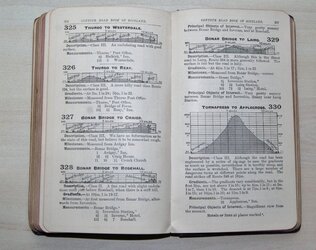
I've also got a 1913 copy of 'The Contour Road Book of Scotland' passed down from my grandfather and father, both keen cyclists in their day, and which is still relevant today as many of the old roads shown are now the back roads used by cyclists.
DSC03395 (1024x812).jpg
 

CharlieB

Junior Walker and the Allstars
Lost count. Hundreds. Love just looking at them, in common with lots of us, it appears. Probably since the day I first saw my sec. school geography teacher had lined up the whole of the South Coast in OS maps from the bottom of one wall, turning the corner and finishing up at the top of the next wall.

Does that make us mapaholics or cartophiles?
 

MontyVeda

a short-tempered ill-controlled small-minded troll
My favourite book is a book of maps. Published in 1910, the Gardiner's Atlas of English History is brilliant. From Roman Britain through to Africa in 1897, with campaign maps of all the main battles along the way. Not so useful on the bike but when its wet and cold and there's nothing on TV (most of the time), you can't beat it. I expect that someone will tell me that an atlas is not a map but they just need to get out more, with a map, of course.

well you sparked my interest so I 'Binged' it... would it be this?

http://www.memoriallibrary.com/MAP/English/toc.htm

:thumbsup:
 
Top Bottom