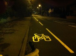
My picture of the day-Where's yours?

Page may contain affiliate links. Please see terms for details.
Friday morning
Circa 04:45

Newly marked lane
'Stanley Hill'
A642 'Aberford Road'
(between Stanley & Pinderfields General Hospital)

Ironically, the traffic on this road, has probably dropped by 75%+, since a 'relief road' was opened a couple of months ago, to bypass this road
22046450_10212773494484488_4241198208456936164_n.jpg

My picture was taken above the car on left, & the new road, curves left, through the position of the stone-wall
http://www.geograph.org.uk/photo/3363698
 

Spokesmann

Keeping the Carlton and Sun names alive...
Location
Plymouth, Devon
Capella lugs...
PA021767_zps8cyxpkdv.jpg


1963 Carlton Catalina.
 
Yesterday

I had intended riding home along the river (Calder) bank, & then through the Woods, but, I got about 50 yards before I was going sideways, but still in the correct direction with both wheels in different ruts, with both mudguards clogged up

I took this. just off the path, on what is called the 'Trash Screen Bridge', it carries a bridleway & vehicular access (via locked gates)
(I detoured onto the bridge, hence the direction the bike is facing)

Road-Trip. 25.jpg


This is it as seen, from the modern Aquaduct
I would have been following the river in the direction of the photograph (shown in map under photo, as 'dismantled railway')
http://www.geograph.org.uk/photo/4907910


NB;

The orange object, in the background, is a North Sea Oil Rig survival 'pod'/craft
The pedico-ed building in the background was the Office for the coal-staithes there; http://www.geograph.org.uk/photo/2416251

This is the history of the older aquaduct; http://www.stanleyhistoryonline.com/Stanley-Ferry-History.html
 
Last edited:
Top Bottom