National Cycle Network: some routes abandoned

Page may contain affiliate links. Please see terms for details.

Fab Foodie

hanging-on in quiet desperation ...
Location
Kirton, Devon.
I'd like to see them clearly labelled according to whether they are suitable for all bikes, including road bikes. So many aren't. MTB-only, or passable with a touring/gravel bike in dry weather (wet too, as long as you don't mind being spattered and grinding down your drivetrain).
I'm broadly in agreement with this.

Keep the signs and the routes, but 'Qualify' some aspects of the route that might be pertinent....

Segments x, y and z are on mud tracks
Part of this route (4.5 miles) is on a major 'A' road
Parts of this route require rider dismounting at mile 57 for 1 mile

It seems that it's an ideological issue more than anything else. I've been critical of many a Sustrans route for not having any of the above info. Now am wise to the vagaries I tend to scrutinize routes more closely and make my own variations. BUT, they are damn good as a starting point and I see no reason why they should be removed - that just seems a waste of money! Just work at either providing greater clarity OR, make more viable workarounds.

@mjr how should we best make our feelings felt on this?

ALSO - the route info/detailed mappage should be free on the interwebs as well as downloadable.
 

Fab Foodie

hanging-on in quiet desperation ...
Location
Kirton, Devon.
On checking routes in my area, I see that most of the cycle routes on this map described as 'Traffic Free' are actually shared use paths,ie shared with pedestrian traffic, so neither traffic free nor segregated cycle routes.
Also, the path widths fall below recommended standards. One section of single track, where I dismount when meeting an oncoming cyclist is designated a "cycle route":sad:.
There are several parts of NCN routes where you need to dismount or are very narrow as an issue in itself, or shared use either. It's a route, not a motorway exclusive to cyclists. BUT it would be good to know this prior to use in case that impacts on your journey.
 
OP
OP
mjr

mjr

Comfy armchair to one person & a plank to the next
@mjr how should we best make our feelings felt on this?
My best guess is that you should contact your local office: https://www.sustrans.org.uk/contact-us/sustrans-offices/

Or you can hop on their social media (linked on there) and add to the fires.

I've done some rough counting from the published map and our tools: Norfolk appears to have about a quarter of its 500km deleted from the map completely (NCN11 where it exits Norfolk south, plus the northern end and southwestern branches of NCN RR30 and the entire NCN RR33), while another 85km has turned into "not on the National Cycle Network" dashed-line route (NCN1+13 Fakenham-Dereham and the rest of NCN RR30): 42% destruction. This seems to me like cowardice, running away from the fight for improvement.

And it will no longer be possible to cross Norfolk by following NCN signs - and it was already rather a roundabout route before, although quite pretty to have to go to either the coast or forest.

I would much rather have seen substandard routes still signed somehow, because there are the triple benefits of easier navigation, some "safety in numbers effect" from concentrating cyclists onto arguably the least shoot route and some signs that drivers may see and realise that they should avoid it if they don't like bikes.
 
Last edited:

Solocle

Über Member
Location
Poole
It's concordant with national sign standards (TSRGD) to use any contrasting colours for a non-national cycle route. You're allowed to use capital letters, too!

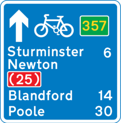
I thought up the following scheme, which obviously is orientated towards roadies like me, and was predicated on substandard routes being part of the NCN (so would be a parallel network):

Patch24.jpg

But it would be quite possible to sign declassified NCN mud tracks in an appropriate brown, while signing an on-road route in perhaps white or black.

E.g. in my area, where there's a good NCN route nearby (plenty of gravel, but I ride it comfortably on 28mm tyres):
NRBN 357_2.png

Although I can't decide if it's wise/lawful to sign the NCN routes with such prefixes.
 

Attachments

  • NRBN 357.png
    NRBN 357.png
    42.6 KB · Views: 1
Last edited:

ColinJ

Puzzle game procrastinator!
Sustrans are deleting routes which they consider unsafe...
I wonder if NCN 68 on the Buttress, Hebden Bridge will make the cut? :whistle:


312 metres long, averaging 23%, with the initial ramp probably hitting 30+%. Cobbled the whole way. Often covered in leaf mulch and other detritus. And damp... Horribly hard to climb and horribly dangerous to descend!
 

ianbarton

Veteran
Most of the NCN routes in Cheshire/Shropshire are pretty good. There are a few parts where the route may be a muddy track, or take a ridiculous loop to avoid 0.5km of a main road. The A525 passes through our local small village. Part of the main road goes through a narrow series of bends in the centre of the village. Average traffic speed around 10-20mph. Route 552 takes a convoluted minor residential road that avoids a couple of hundred yards of this distinctly non-dangerous bit of the main road.

I always use the NCN routes as a good starter for a route in a non-familiar area. Then I look at the map and decide which part of the NCN route I need to modify/avoid.
 

Fab Foodie

hanging-on in quiet desperation ...
Location
Kirton, Devon.
Most of the NCN routes in Cheshire/Shropshire are pretty good. There are a few parts where the route may be a muddy track, or take a ridiculous loop to avoid 0.5km of a main road. The A525 passes through our local small village. Part of the main road goes through a narrow series of bends in the centre of the village. Average traffic speed around 10-20mph. Route 552 takes a convoluted minor residential road that avoids a couple of hundred yards of this distinctly non-dangerous bit of the main road.

I always use the NCN routes as a good starter for a route in a non-familiar area. Then I look at the map and decide which part of the NCN route I need to modify/avoid.
Well quite!
As a relative newbie to Kent I've been using the NCN as an initial guide and thus far have been pleased with the routes I have traveled. Now am starting to make tweaks for future adventures....
 
D

Deleted member 1258

Guest


312 metres long, averaging 23%, with the initial ramp probably hitting 30+%. Cobbled the whole way. Often covered in leaf mulch and other detritus. And damp... Horribly hard to climb and horribly dangerous to descend!


That looks like a challenge.
 

ColinJ

Puzzle game procrastinator!
That looks like a challenge.
I have never tried riding up it. If I were 25 years younger with a better health history then I would have a go, but I think it might kill me now! :laugh:

I only tried riding down it once and went over the bars when I panic-braked... That put me off trying it again! :okay:

In the context of this thread though... It was a ludicrous decision to use the Buttress for a national cycle route. There is a perfectly good (steep) road not far away which could have been used - Moss Lane, 280 metres at 21.5%. What probably put them off is that there is a 30 metre long 25+% footpath at the top which would need to be walked. That is the way that I used to go if I wanted to avoid the town centre.

537122


Much easier (and safer!) than NCN 68!
 
OP
OP
mjr

mjr

Comfy armchair to one person & a plank to the next
I wonder if NCN 68 on the Buttress, Hebden Bridge will make the cut? :whistle:
Yes, The Buttress is still accepted by Sustrans. The only bit of NCN in Hebden Bridge to change is they disown the link using Heptonstall Road and Bridge Lanes to avoid it!

As I understand it, disowned routes (shown on the map linked in the first post as dashed lines) will be marked with blue blobs on OS Maps instead of the current green ones, won't have numbers on their signs and Sustrans volunteers won't check them for signs or faults or put up stickers for them.

ETA: And deleted routes (no longer shown on the map linked in the first post) will not have any map blobs and possibly no signs.
 
Last edited:

screenman

Legendary Member
Just reminded me I need to stock up on some more inner tubes, I overlook the summer route of the route through Bardney and have over the years given away I expect over 20 new tubes to people I see pushing their bikes, be nice if some of them had done as they promised and dropped one back, but hey ho I am not going to stop helping people. It is almost worth getting a puncture like the last bloke, new tube in back wheel, new tube to take away as a spare, cup of tea and a slice of cake promised to come back and replace them short memory i guess. Getting back to the route, it was topped up a few years back by the farmer using old raod chippings and lots I mean lots of glass, the Hawthorne hedges are kept nicely trimmed though, which of course means, yep you guessed. One tramaced part of it was extremely overgrown a while back, so I phoned it to be told the contractor was doing it every two weeks, he might have been sending a bill in every two weeks but cutting it, no.
 

Slick

Guru
Just reminded me I need to stock up on some more inner tubes, I overlook the summer route of the route through Bardney and have over the years given away I expect over 20 new tubes to people I see pushing their bikes, be nice if some of them had done as they promised and dropped one back, but hey ho I am not going to stop helping people. It is almost worth getting a puncture like the last bloke, new tube in back wheel, new tube to take away as a spare, cup of tea and a slice of cake promised to come back and replace them short memory i guess. Getting back to the route, it was topped up a few years back by the farmer using old raod chippings and lots I mean lots of glass, the Hawthorne hedges are kept nicely trimmed though, which of course means, yep you guessed. One tramaced part of it was extremely overgrown a while back, so I phoned it to be told the contractor was doing it every two weeks, he might have been sending a bill in every two weeks but cutting it, no.
That's really poor form that. :sad:
 

ColinJ

Puzzle game procrastinator!
Fab Foodie knows Smalldean Lane in the Chilterns quite well; it's about 1 in 4 at its steepest and the tarmac won't even stick to it properly. It's on a NCN route!
The Streetview picture I posted above of Moss Lane in Hebden Bridge shows that it has a concrete surface, presumably for the same reason!

As does equally steep Highfield Crescent...

537158


I hadn't really thought about it much before, but it must be something to do with hot tarmac sliding downhill?
 
Top Bottom