Strava or RidewithGPS

Page may contain affiliate links. Please see terms for details.
Location
Pontefract
rwgps for planning, down load the tcx edit in tcx converter if you want the V.P. to resemble anything like your speeds, rwgps can flip between several map types including satellite which can be useful to see if a road is a road or a track because trust me around here just because its a road on a map the surface sometimes is nothing more than rubble.
 
Location
Pontefract
Whats that got to do with anything? The point was that there is no point paying for premium for ridewithgps, if your after upload to your garmin, when you can do it for free. I was not claiming that everything in the world should be free.
There is more to the premium version than the ability to load direct to your gps unit. Like with strava ect.... Garmin is subsidised from the sale of its units which is why its c***.
 

Ansome

Well-Known Member
I have no problem paying for a RwGPS subscription because although I can use all the services I need for free I also want to be one of those that support their efforts to improve their offering further, for example their recent Android app. That was what I was getting at as far as why someone might go Premium, even though yes, it's available 'for free'. Sorry if my reply was a bit sarky. Moody git I am. Pipe was out too.
 
Location
Pontefract
I have no problem paying for a RwGPS subscription because although I can use all the services I need for free I also want to be one of those that support their efforts to improve their offering further, for example their recent Android app. That was what I was getting at as far as why someone might go Premium, even though yes, it's available 'for free'. Sorry if my reply was a bit sarky. Moody git I am. Pipe was out too.
I would love to subscribe but I don't work, and all my spare cash goes on the bike, some new clothes and wheels (f'd up the new rear wheel hitting a stone) are next and possibly the saddle if I don't get on with this one.
 

prentick

New Member
Hey all!

Great thread you've got going on here. I'm actually one of the four people that work at Ride with GPS. You are all correct in that most of our site is free to use (including exporting a ride file for upload to a Garmin), and we encourage everyone to get as much out of the site as they can, whether they have a paid membership, or they are a free Starter user. We just make additional features available for paid accounts to make some functions easier and give you more advanced planning and analytical tools. We have no investor money, no advertisements on the website or in our apps, and no alternative products or services to get in front of you except the cycling tools that we build for you, which were requested by you. Money from memberships is the sole way we keep the lights on. Some members find these additional features more than worth the price of a membership. Others do not. We are fine with that either way. Ansome, as you stated, our money from memberships enabled us to develop and release our Android app earlier this year, and our soon to be iOS app coming out in a couple weeks. Same scenario here, the app is free to use, free to record your rides, and free to search for other rides. But most riders feel the Basic paid membership is well worth the built in voice navigation they are going to get for all of their routes (as well as live-logging).

If anyone has any questions or feedback please feel free to email us at info@ridewithgps.com. We provide an exceptional level of customer support, and are always happy to help our members and answer any questions they might have. Whether they are free users or contributing members.

Cheers.
Kevin
 

Ansome

Well-Known Member
Thanks for adding that prentick, I was given a trial Premium membership as part of the Android app beta test group but have converted it to a Basic one as, like nigel above me, budget is finite. I would suggest to you though that for international use I think there may be a way of making the amount of the subscription show in the local currency?
$6 per month is less than the price of one of the glossy bike mags, but £3.49 sounds even better and I know I can do without another advert filled comic.
 

Debade

Über Member
Location
Connecticut, USA
I know this is an old post. I thought I would start here with my question. When creating a route using RidewithGPS, a route, typically on an off road bike route, will not allow me to record the route. For example, yesterday when creating a ride, I clicked along the bike off road bike trail. I reached the bike pedestrian bridge and clicked to the other side. I was at the 22 mile mark. Then with my next click on the bike path, the mapping tool took me to the 36 mile mark. I could not put a routing marker between the 22 and 36 mile mark. This problem also happens with BikeRouteToaster. But, not with MapMyRide which works as expected.
Just for background, MMR does not use TCX and I like the turn-by-turn I get on my Garmin Edge 500 when I upload the map to the Garmin from RWGPS. So, we (wife) route on MMR and move it to RWGPS. Toaster is another option that I would like to try since it has turn by turn and offers a 'turn warning' prior to the turn for no additional cost. But, the routing problem is still an issue. HELP :smile:
 

Supersuperleeds

Legendary Member
Location
Leicester
I know this is an old post. I thought I would start here with my question. When creating a route using RidewithGPS, a route, typically on an off road bike route, will not allow me to record the route. For example, yesterday when creating a ride, I clicked along the bike off road bike trail. I reached the bike pedestrian bridge and clicked to the other side. I was at the 22 mile mark. Then with my next click on the bike path, the mapping tool took me to the 36 mile mark. I could not put a routing marker between the 22 and 36 mile mark. This problem also happens with BikeRouteToaster. But, not with MapMyRide which works as expected.
Just for background, MMR does not use TCX and I like the turn-by-turn I get on my Garmin Edge 500 when I upload the map to the Garmin from RWGPS. So, we (wife) route on MMR and move it to RWGPS. Toaster is another option that I would like to try since it has turn by turn and offers a 'turn warning' prior to the turn for no additional cost. But, the routing problem is still an issue. HELP :smile:

There is an option to draw a line or something like that. It will let you draw a straight line from your last point on the route to wherever you click on the map.
 
D

Deleted member 23692

Guest
I use RWGPS exclusively for planning and recording rides, as i'm really not interested in all the segment KOM bollocks that comes with Strava. I did use map my ride but got pissed off with all the spam they sent me

@prentick - windows phone app please. You'll have another paying member then ;)
 

Dogtrousers

Kilometre nibbler
@prentick - windows phone app please. You'll have another paying member then ;)
I emailed them and asked just this. Here's the reply (21st Apr 2014)
We don't have any plans for developing our own windows phone app, but there are a couple of apps out there already that integrate with our service. Check out Cycle Tracks GPS. It will upload to your RWGPS account directly, and the developer is super nice and responsive.

I installed the app, but to be honest I've never used it because actually my Garmin does all that I need.
 
Location
Pontefract
@Debade what @Supersuperleeds says, there is an option to draw a line between two points useful, in cases like you describe.

I use RWGPS exclusively for planning and recording rides, as i'm really not interested in all the segment KOM bollocks that comes with Strava. I did use map my ride but got pissed off with all the spam they sent me

@prentick - windows phone app please. You'll have another paying member then ;)
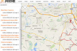
But rwgps does it too.

upload_2015-3-5_17-46-33.png

upload_2015-3-5_17-47-22.png

Its a shame they don't organise the segments as they are ridden like strava.
 
Top Bottom