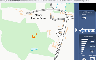
Here's a screenshot from (1:25,000)
Streetmap.co.uk with that OS Grid 'searched for' [ SJ 79854 67142 ]
There will be other clever people along, but you will have a paper plot of where all your special trees are (metasequoia glyptostoboides anyone) and can move the arrow around to get a read out.
Consider what the best coordinate system is for your use (see options below so maybe WGS84 or OSGB36 (OS maps) and Lat/Long but this GR is a 1m x 1m square defined by its SW corner). There may also be a recommended worldwide standard in the forestry/arboretum 'space'.
Also if this output is derived from a hand held GPS it'd be worth taking more than one reading (eg beside the east and west sides of each tree and averaging (satellite visibility and other minor errors)).
Ask yourself what the purpose is, who might use the information (and how) and how are they going to access it.
Pub front door: SJ8000167176
View attachment 715523
OS X (Eastings) 379777
OS Y (Northings) 367207
Nat Grid SJ797672 / SJ7977767207
Nearest Post Code CW12 2LH
Lat (WGS84) N53:12:06 (53.201548544084524)
Long (WGS84) W2:18:15 (-2.3041994945026976)
Lat,Long (WGS84) 53.201548544084524,-2.3041994945026976
Lat (OSGB36) N53:12:05 (53.20126843374148)
Long (OSGB36) W2:18:10 (-2.3027787333742404)
Lat,Long (OSGB36) 53.20126843374148,-2.3027787333742404
what3words bristle.quail.lush
Open Loc/Plus code 9C5V6M2W+J87