LEJOG - local/previous knowledge required

Page may contain affiliate links. Please see terms for details.
OP
OP
Lpoolck

Lpoolck

Veteran
That's better. The path by the river isn't going the way I meant but that reroute has put you onto some quieter residential roads than the ones on the original.:okay:

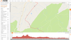
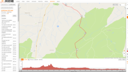
The bit through Cardington to Shrewsbury is great but I'd reroute it slightly from miles 26-30 to pass Comley rather than Enchmarsh and Lawley as that reduces the amount of climbing (the climb up to Enchmarsh is an evil one that gets steeper the further up you go).

Thanks again @Rickshaw Phil I made that amendment you have suggested to pass Comley rather than Enchmarsh. However it added an extra 286 feet according to ride with GPS - it it one of those roads that actually climbs but it feels like a flat/downhill for whatever reason. I have one of those next to me!
 

Attachments

  • Comley.png
    Comley.png
    102.4 KB · Views: 75
  • Enchmarsh.png
    Enchmarsh.png
    95.1 KB · Views: 80
Last edited:
OP
OP
Lpoolck

Lpoolck

Veteran
The only reason to go to Tongue on day 10 is to stop at the hostel.
It's both shorter and flatter to turn right at Altnaharra on the B873 alongside Loch Naver direct to Bettyhill.

Thanks @Tigerbiten that has saved me 5 miles and 1065 feet of climbing. I just kept on the road to Tongue as it was a national cycle route, plus it looked pretty scenic. However the 1065 feet of saved climbing sounds more appealing on my last day :biggrin:
 
OP
OP
Lpoolck

Lpoolck

Veteran
I don't understand the double-back after mile 60 near West Lyng. Also, the A361 is pretty grim cycling - pretty narrow with some motorists driving too fast for the road - so I'd either continue on the canal/river paths and back roads (NCR 3 / 33) until north of the A39 and rejoin your route at Shapwick, or use the parallel back roads through North Curry, Athelney, Burrowbridge, Middlezoy, Greylake and then the minimum of the A361. I'd also cross straight across the A39 if you can - I've had a few scares from motorists on that road, including when driving. The Wedmore-Cheddar B road isn't the most fun either but it's usually OK and I think it's gently downhill and pretty simple in that direction, which might be good near the end of a day.

Thanks @mjr I am not sure, I must have dropped a pin near West Lyng by mistake, thanks for pointing that out! I have amended it to follow the canal path through North Newton. I have avoided the A39 but the only issue is that you have to do a big loop near Bridgewater so it has added a few miles and feet of climbing to the route, but if its worth avoiding I don't mind.

https://ridewithgps.com/routes/20771963
 
OP
OP
Lpoolck

Lpoolck

Veteran
On day 1 you would be better going along the A3075 and cutting across to St Columb Major following the A39 to Camelford to rejoin your existing route. This avoids a nasty section of the A30.

Thanks for your help @Ian H Is the A39 not quite bad too with lorries? Would it not be best to avoid that route too?

Day 1 defintely needs amending. I just don't know what is the best way to do it! Surely loads of people have done this route from Lands End to Okehampton.
 
Last edited:

Vegan1

Guest
Nothing to add except rather you than me riding all those country lanes - chapeau.

And the Mersey ferry in good weather is a joy, and Liverpool YH (I presume?) is really good for getting your kit clean and your head down. All the best with your ride.

EDIT: No detour to Dunnet Head on the final day? It's the most northern point on the main island.
 

Ian H

Ancient randonneur
Thanks for your help @Ian H Is the A39 not quite bad too with lorries? Would it not be best to avoid that route too?

Day 1 defintely needs amending. I just don't know what is the best way to do it! Surely loads of people have done this route from Lands End to Okehampton.

The A39 tends to be more local traffic. You will get the usual rush-hour spates. Until you get east of Launceston there is a serious trade-off between hills and main roads.
 
OP
OP
Lpoolck

Lpoolck

Veteran
Nothing to add except rather you than me riding all those country lanes - chapeau.

And the Mersey ferry in good weather is a joy, and Liverpool YH (I presume?) is really good for getting your kit clean and your head down. All the best with your ride.

EDIT: No detour to Dunnet Head on the final day? It's the most northern point on the main island.

Cheers, I'd rather a few extra miles on peaceful country lanes than taking the shortcut through busy roads!

Yeah I'm staying at Liverpool YHA, most the YH are set up great for storing your bike and drying your kit. If we have time we will check out the ferry thanks.

And zero thanks for the detour :laugh:, I never realised it was the most north part of the island. I'm going to have to add that to the route now. :wacko:
 

Vegan1

Guest
Cheers, I'd rather a few extra miles on peaceful country lanes than taking the shortcut through busy roads!

Yeah I'm staying at Liverpool YHA, most the YH are set up great for storing your bike and drying your kit. If we have time we will check out the ferry thanks.

And zero thanks for the detour :laugh:, I never realised it was the most north part of the island. I'm going to have to add that to the route now. :wacko:

Good job.

RE: Unless it has changed you need to take the ferry from Birkenhead across to Liverpool? Or were you planning to take the Mersey tunnel? Bikes AFAIK are not allowed, which is why you need the ferry. It's all good mind, it was a pound way back when I done LEJOG.
 

classic33

Leg End Member
Good job.

RE: Unless it has changed you need to take the ferry from Birkenhead across to Liverpool? Or were you planning to take the Mersey tunnel? Bikes AFAIK are not allowed, which is why you need the ferry. It's all good mind, it was a pound way back when I done LEJOG.
14. Can I ride my bicycle through the tunnel?

Bicycles are not permitted through the Kingsway Tunnel. Through the Queensway Tunnel, they are not allowed between the hours of 6:00am to 8:00pm, Monday to Friday, 7:00am to 8:00pm on Saturday and 8:00am to 9:00pm on Sunday. Please note, the time limits during a Sunday are only operational between 1st April and 30th September inclusive.

http://www.merseytunnels.co.uk/nossl/html/faq.php#14
 

Rickshaw Phil

Overconfidentii Vulgaris
Moderator
Thanks again @Rickshaw Phil I made that amendment you have suggested to pass Comley rather than Enchmarsh. However it added an extra 286 feet according to ride with GPS - it it one of those roads that actually climbs but it feels like a flat/downhill for whatever reason. I have one of those next to me!
I think that could be a glitch with Ride With GPS. On the Comley version of the route the summit is at mile 27 then you have a long and fun descent after which the gradient stays mostly in your favour all the way to Shrewsbury. (All being well the prevailing wind should be helping you along on this stretch too.)

On the Enchmarsh version the summit is 150 feet higher (and consequently a steeper climb) then RWGPS appears to take you along an unmade farm track before you start descending past Lawley. There is a road alternative to the track but that involves a bit more climbing still..... Great views from the top though.;)

Edit to add: RWGPS hasn't altered the route anywhere else when you made the changes? That might account for the claimed extra climbing?
 
Last edited:
Thanks @Tigerbiten that has saved me 5 miles and 1065 feet of climbing. I just kept on the road to Tongue as it was a national cycle route, plus it looked pretty scenic. However the 1065 feet of saved climbing sounds more appealing on my last day :biggrin:

I used the B873 from Alnaharra to Bettyhill on my recent LEJOG in May. It is a stunning route alongside Loch Naver. Highly recommended.

Graham
 
Top Bottom