Poor Quality Sustrans Routes

Page may contain affiliate links. Please see terms for details.
OP
OP
rostlr

rostlr

New Member
You want to try NCN 68 through Hebden Bridge! :eek:

buttress.jpg
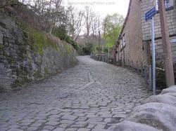
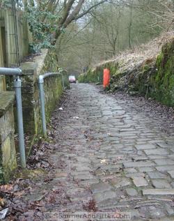
mmm, I would ride that on my road bike for fun though...
 

Attachments

  • buttress.jpg
    buttress.jpg
    85.3 KB · Views: 41

ColinJ

Puzzle game procrastinator!
Cycling Plus did a local ride including a photo shoot on The Buttress last year. They claimed that one their riders managed to clean the ascent once, but I've never managed it. Svendo had a go and he is vastly fitter than me, but that first steep ramp did for him too. The council cleared the moss and damp leaf mulch off the cobbles some time over the winter so it isn't quite as lethal as it normally is but I still find it a terrifying prospect to ride down.

I actually think it is irresponsible to have an NCN 68 sign at the top pointing down the descent without any warning about its dangers. Mind you, you'd have to be pretty blind not to notice! Here is the view from the top - note how slippery the leaf-strewn cobbles are, and also the idiot obeying a SatNav and trying to drive to the top! (He had to stop and reverse all the way down.)

driving-up-the-buttress.jpg
 

Attachments

  • driving-up-the-buttress.jpg
    driving-up-the-buttress.jpg
    70.3 KB · Views: 43

MrJamie

Oaf on a Bike
There's a bit near Cranfield I tried a few years ago, which was about 1km of sand. Not easy to cycle on.......
I seem to remember the farm road goes downhill from Cranfield into that sandy park and theres a barrier accross the end of the lane at the bottom of the hill that you dont get a massive amount of warning for if youre racing down the hill like an idiot :whistle:

Of the few routes ive tried, theyre pretty poor for getting anywhere quickly and all had sections which id guess would be awful for road bikes. I think it was a sustrans route at Castlethorpe that had 200 metres through a freshly ploughed field which was a struggle even with mtb tyres and a short uphill on slippy wet mud. The afore-mentioned MK>Cranfield>Bedford section is about 35k on NCR and about 25k if you just stay on the relatively quiet road it jumps off and on. Theres another part somewhere along a towpath that was covered in small apples for miles, which is a little scarey next to water. Im sure Sustrans wouldnt use it as a selling point, but ive really enjoyed the quirky bits and variation on the routes with road sections, sand, mud, grass - all quite fun on a MTB/hybrid for leisure cycling. :smile:
 
Well at least with anyone who moans about it they should not be short of volunteers, of course nobody would complain and then not do anything to help would they.

Oooh get you haha:laugh:

Its funny you should mention volunteering as I get a day through work for volunteering, I'm trying to get some things organised with a new(ish) cycle group we have so I'll see where that goes. Its more likely I could end up doing something on the TransPennineTrail as that is what I ride more but anything is possible TBH

Couple more, took on my phone so poor quality:

Ideal NCN material here, its outside Sheffield on NCN67 a disused railway offers a flat surface that'll probably go near(ish) somewhere you want to go. Theres miles of this sort of trackbed unused BTW that I think should be.
Image004.jpg


Not quite so ideal, again its the same route so this is kinda what I mean - a route can start of pretty nice but theres a little lack of consistancy for a 'National Cycle Network'. Its not just the surface either as the thinner path can cause probs, I do take care on such paths but I've been passed by other cyclists that dont.
NotMineBarnsleyCanal.jpg
 

Attachments

  • Image004.jpg
    Image004.jpg
    11.4 KB · Views: 42
  • NotMineBarnsleyCanal.jpg
    NotMineBarnsleyCanal.jpg
    11.4 KB · Views: 59

the_mikey

Legendary Member
I think sustrans should classify routes, allowing you to decide long in advance if the route is suitable for you without having to find out that 20 miles into your ride, you're up to your rims in mud and trying to scrape it out from your brake calipers before turning around to abandon the ride.
 
I think sustrans should classify routes, allowing you to decide long in advance if the route is suitable for you without having to find out that 20 miles into your ride, you're up to your rims in mud and trying to scrape it out from your brake calipers before turning around to abandon the ride.

I like that, I dont have time today but maybe we should start a reference thread for NCN routes - a bit like the way that the 'places you avoid on your commute' is becomming a bit of a reference.
 

deptfordmarmoset

Full time tea drinker
Location
Armonmy Way
I like that, I dont have time today but maybe we should start a reference thread for NCN routes - a bit like the way that the 'places you avoid on your commute' is becomming a bit of a reference.

In the past I've uploaded photos to cyclestreets.net when I've come across bad or vague bits of the NCN network - that's exactly what I did with the NCN21 photo I linked earlier. I don't know whether there's a cyclestreets-to-Sustrans feedback system, but at least anybody who looks on cyclestreets and gets a suggested route on local NCN routes will get to see some of the hazards because, where a route crosses a place for which there's a photo, the photo gets built into the route directions. Cyclestreets was the best place that I could think of to put the photos .
 
Hmmmm Cyclestreets, I'll have to try it. How do you rate it to say 'Mapmyride' if you use that? e.g. I like on mapmyride that it gives me the elevation - help avoid surprise ascents!
 

deptfordmarmoset

Full time tea drinker
Location
Armonmy Way
Hmmmm Cyclestreets, I'll have to try it. How do you rate it to say 'Mapmyride' if you use that? e.g. I like on mapmyride that it gives me the elevation - help avoid surprise ascents!

Cyclestreets is an A to B route planner that gives you 3 differently graded route suggestions and a rudimentary elevation profile. You can't put your own route into it as far as I know or tell it to go round unnecessary hills. It's good for getting the lie of the land, though I don't think I've ever followed a cyclestreet route exactly.
 
Cyclestreets is an A to B route planner that gives you 3 differently graded route suggestions and a rudimentary elevation profile. You can't put your own route into it as far as I know or tell it to go round unnecessary hills. It's good for getting the lie of the land, though I don't think I've ever followed a cyclestreet route exactly.

I just gave it a go and I think as a 'get me there' tool its useful, but not one I'd use to plan a leisure ride. Still good to know about:thumbsup:

Incidently can you access Sustrans mapping ATM Every time I try to search the map doesn't appear: http://www.sustrans.org.uk/map?searchKey=london&searchType=search&Search=Find
 
OP
OP
rostlr

rostlr

New Member
Just had a look at the cyclestreets site. It looks OK, although I didn't get a map up straightaway - had to enter departure and destination and similar technology to what TFL use for route planning around London (Yes I'm a Boris biker)

Have you looked at the Photo maps? If you register you can post and tag photos. There are not too many for my area yet though
 
And Heres me about to quibble over some rough cobblestones on route NCR 4 in the centre of Bristol!
Though why I thought out to post on here is just to ask if there are any other parts of the national cycle route network that seem really well signposted in one area then as you move though that area to perhaps another district that is a different council In this instance south Gloucestershire some of the signs seem to be there and further along the route they disappear Ok perhaps I was going to fast! But I know I was on the route Are we being taught navigation? I some how doubt it in this present culture; I wonder are there any other areas that suffer like this.
As to the state of some of the tracks that take you off the tarmac of minor roads on to one of the NCR’s the one by me which I can relate to is the Strawberry line route 26 while parts of it are fine and can be rode on any time of the year there are parts which at the first onset of rain regress into a morass of large muddy holes though I must say that most of it is fine as its well drained fine gravel surface. but as has been already stated you don't want to get so far into a ride only to have to turn back to find an alternate route.
There I feel much better now after having my morning rant!
 
Signing of NCN and all other Sustrans routes is down to Sustrans generally, although any signs physically on the public highway itself such as announcing a nearby cycle path would normally be the local authority.

As Sustrans routes and signs are maintained by local volunteers, it's often the case that some stretches don't have anyone looking after them on a regular basis. Why not sign up to Sustrans as a volunteer, to look after a neglected spot?
 
Top Bottom