Route planning apps or software

Page may contain affiliate links. Please see terms for details.

Mark Grant

Acting Captain of The St Annes Jombulance.
Location
Hanworth, Middx.
Ride with GPS lets you print cue sheets, I'm sure others do too.
 

youngoldbloke

The older I get, the faster I used to be ...
Bikehike allows you to plot your route and print it. You can then produce your own cue sheet by 'riding' the route and noting 'SO at X', 'R at T', '3rd R' village names, etc etc. Streetview can help you 'ride' the route too, and note signposts etc. The ride with GPS cue sheets are too detailed, and you can end up with reams of paper, but you could simplify them.
 
Another shout for Ride With GPS. I find it the easiest route planner to use. Just make sure that all of the roads are rideable by dragging the "streetview man" onto the map to make sure the road turns blue. If the road doesn't turn blue, the streetview car didn't go down there so it might be a MTB/hybrid only route.
 

steveindenmark

Legendary Member
I have never Tried with Plotaroute.com but everything else is brillant. The guy who runs it listens to what everyone says and if it isnt in the programme he adds it PDQ if it is possible.
 

robgul

Legendary Member
Ditto Ride with GPS - and it's worth paying a few dollars each month for the Pro version and the extra bells and whistles that you get.

Rob
 

Eribiste

Careful with that axle Eugene
Another vote for careful checking of the route here. I used one of those MapmyGPSToaster sites for a ride on Saturday without properly checking before downloading it onto my Edge 200. I ended up doing a considerable distance along some highly unsuitable territory indeed for a roadbike.
 

HorTs

Über Member
Location
Portsmouth
Another here for Ride with GPS.

Strava planner isn't very good abd you need premium (I think), MapMy Ride is ok, another to try would be Bike Route Toaster (though I'm not sure that is working at the moment).
 

jiberjaber

Veteran
Location
Essex
I don't think you need Premium to plan routes in Strava.

I tend to use Garmin, Strava and Google earth (plus the bagel one for an idea on the weather). Strava because I get a decent consistent view of % gradient to help judge the hill based on previous hills I have ridden, Garmin because I then have the way of putting it on my Garmin and reviewing rides of the same course in a different way than Strava gives.
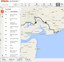
Another positive about Strava is I can duplicate the route, so I can look at different variations without deleting the options. Downside is it does cue sheets, but there doesn't seem to be a way to print them out?

If Garmin supported gradient and being able to make a copy of "courses" it would be so much better.
If both supported a "waypoint" function (for coffee or controls) then even better!

Google Earth essential because they both can sometimes be a bit daft on choice of route, so it pays to check out the road before you get there!

Screen capture of cue sheet function on Strava for OP, like I said, cant see a way to get it off the screen on to a bit of paper though :sad:
 

Attachments

  • stravarouteCapture.JPG
    stravarouteCapture.JPG
    113.4 KB · Views: 27
Top Bottom