I don't think you need Premium to plan routes in Strava.
I tend to use Garmin, Strava and Google earth (plus the bagel one for an idea on the weather). Strava because I get a decent consistent view of % gradient to help judge the hill based on previous hills I have ridden, Garmin because I then have the way of putting it on my Garmin and reviewing rides of the same course in a different way than Strava gives.
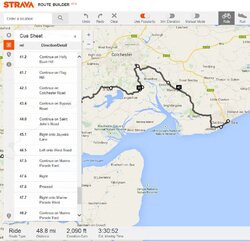
Another positive about Strava is I can duplicate the route, so I can look at different variations without deleting the options. Downside is it does cue sheets, but there doesn't seem to be a way to print them out?
If Garmin supported gradient and being able to make a copy of "courses" it would be so much better.
If both supported a "waypoint" function (for coffee or controls) then even better!
Google Earth essential because they both can sometimes be a bit daft on choice of route, so it pays to check out the road before you get there!
Screen capture of cue sheet function on Strava for OP, like I said, cant see a way to get it off the screen on to a bit of paper though