I log my own component parts, mainly out of interest, its like the new shifters have done just short of 600 miles the Sora 9sp lasted about 2,500 miles and my front tyre 7664 without a visit
 @SpokeyDokey
 rwgps will give better elevation data, but I think there is a problem (or was) with the conversion from the fit format that the newer Edge units use.
The 200 and the R20 take the elevation from the gps plot when uploaded to a site, more expensive units have a barometric altimeter which is suppose to be more accurate, though temp and sudden pressure changes can effect this, as can stopping for

or

.
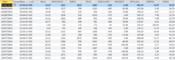
My last few rides showing the rwgps 705 data corrected on rwgps, the elevation from the Bryton unit and the raw data from the 705
Today the R20 was 436ft less than that corrected by rwgps the 705 only 6ft, but as you can see it varies.
To backup just copy the files from the gps unit with garmin you can drag and drop, bryton you use the bryton bridge to transfer.
The strava segment is just as good for your own p.b's, though after a while your local segments will be come difficult to beat as at some point you will do them on a good day with a good tail wind, and after that the prove almost impossible to beat, part of the reason I look for roads I havent done before ( which are pretty few and far between in a 15 mile radius which actually is a lot of roads.)
Veloviwer is a better site to analyse your data, it uses the data from strava so you still need to upload to strava, but much more comprehensive.
Be sure a base model is what you want long term though, the R20 does Ant+ Edge 200 doesn't, so if you want HR ect in the future you will need the 500/10 up or any Bryton, if not the course feature on the 200 might be useful I found the one on the 500 to be so.
In a nutshell none are perfect, each has their +points and -points, if you only compare the elevation from one site from ride to ride it gives an idea how difficult each ride was. I could go on about that one.
Same table as above using the climbybike formula to give a difficulty score, also a ft/mile, (taken from the corrected rwgps data)
The difficulty per mile tends to drop the further I go, just goes to show how flat it isn't around here, but it is only really pretty local. but it does show how a 1.8 mile ride can be more difficult than a 6.4 mile ride, or 32 mile ride is more difficult than a 62 mile ride, and as stands to reason the more you climb per foot the slower you tend to be though not always.

 Sun's out now though so it'll soon warm up.