Strava elevation gain

Page may contain affiliate links. Please see terms for details.

bpsmith

Veteran
I have the Edge 510, along with my mate. Bought on same day from same place. We recently did a medium length charity ride at a very casual pace with others. He did 5 more miles, with a tiny gradient one way. My total climbing was 2080 feet and his was 2850 feet!

Can't explain it at all. Anyone else?
 

mattobrien

Guru
Location
Sunny Suffolk
I find that my Garmin 510 over estimate the gradient of any ride. Why on earth they would decide to use barometric señor to determine elevation is beyond me, it has never even been close to accurate.

I always 'correct' my elevation in Strava as I know, living in Suffolk, that I have not climbed anywhere near the ascension Garmin claims. We don't have any hill here.
 

NorvernRob

Veteran
Location
Sheffield
For any given elevation gain when I map a ride online, my Garmin tends to read around 10% over that and Strava (via my iPhone) around 20% under.

I did a sportive that the profile said 3,500ft, strava said 2,800 and both mine and my mates Garmin said around 4,000ft, so I would think those 10 and 20% figures are about right.

Apparently Strava calculates elevation data from a start and finish point of a climb but does not take into account any dips and hence extra elevation in between those points. It also says in their own explanation of how they calculate elevation that long flat sections can throw off their data, which is strange as there aren't any long flat sections around here and they always rip me off with elevation.

For instance, my training run hasn't got any major hills, but is hardly ever flat and Strava gives me an elevation of around 1030ft over 19.4 miles. Yet a 50 miler in the Peak District where it feels like all I'm doing is dragging my arse up long climbs it gives me as little as 3000ft! Not a chance.

At the end of the day it doesn't really matter as long as you know roughly how far out they are so if mapping future rides you know how hard they're going to be. It just would be nice to have an accurate record of how much climbing you'd actually done.
 

bpsmith

Veteran
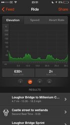
Did a test tonight on a relatively flat 20 mile route. iPhone 5S showed 609ft and 510 showed 630ft. I can live with that sort of comparison. Still cant understand why my mate's 510 shows way higher though. Might be worth doing a test starting at the exact same start and finish point? My motivation is that a group of us all want to compare to each other and we want to be able to fairly do so. My mate will always win as he just loves the hills!
 

Jenkins

Legendary Member
Location
Felixstowe
So which of the elevation profiles used by the mappers is the most accurate?

On a recent ride the readout on my Garmin Touring Plus (barometric sensor) showed the equivalent of approximately 2000ft of climbing When uploaded to Garmin Connect and the elevation corrections enabled the total was 1600ft. On Strava which doesn't recognise the barometric sensor on the Garmin it was 1500ft and when mapped out on Bikehike it was 1700ft (figures rounded up but close enough)..
 

bpsmith

Veteran
Isn't your Garmin based on the 510? Which happens to be recognised by Strava as long as you upload from the device direct and don't send across in a GPX file from Garmin Connect. Mine matches exactly between GC and Strava and no correction required by either.

As far as enabling correction, both GC and Strava usually increase my elevation no matter where I cycle. I am wondering if it's due to being by the coast at all? Stab in the dark at best mind you.
 

bpsmith

Veteran
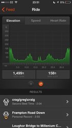
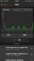
Just did a quick check on 2 different mates, using different devices, but very similar route to what I did tonight. Wonder if you can guess which are my stats...
 

Attachments

  • image.jpg
    image.jpg
    37.6 KB · Views: 16
  • image.jpg
    image.jpg
    37.3 KB · Views: 19
  • image.jpg
    image.jpg
    37.1 KB · Views: 20
Top Bottom