Weird elevation profile on RWGPS

Page may contain affiliate links. Please see terms for details.

livpoksoc

Guru
Location
Basingstoke
Hi guys,

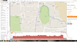
I've been trying to edit a ride which I found on rwpgs which is near me, but I tried to adjust the start & end points so they are near to me and/or where I can park the car.

When I edited it though, the route wasn't perfectly overlaid on the roads & I noticed the elevation profile was weird at either end of the route - i.e. a very sharp incline/decline. I can only assume this is because either the original route I'm editing is incorrect, or rwgps, because I know there is no climb of that kind at either of these points.

A screenshot is attached for ref.
 

Attachments

  • Capture.PNG
    Capture.PNG
    84.5 KB · Views: 42
OP
OP
livpoksoc

livpoksoc

Guru
Location
Basingstoke
Not to worry, I got it fixed. I think the file was probably from someone using a mobile app or simple drawing tool as opposed to direct from RWGPS in the first place. When I reviewed it and added my own control points and rerouted the route through those, it drew a more accurate route & the elevation profile adjust accordingly. Wherever the original file came from, the elevation began at the wrong height.
 
D

Deleted member 23692

Guest
I wouldn't worry too much as the digital terrain model that RWGPS (and others ) use is anything but accurate.
 

Banjo

Fuelled with Jelly Babies
Location
South Wales
I get a huge jump in elevation at the start of my rides sometimes. I think its the GPS calibrating itself on start up.
 
D

Deleted member 23692

Guest
Maybe you were lucky :smile:

Take this route for example.....

full.png


As plotted on RWGPS : +629 / -627 ft
Checked against OS DTM : +823 ft / -822 ft

Track from GPS loaded into RWGPS after being ridden : +750ft / -871 ft
Above track checked against OS DTM : +818 ft / -818 ft

Ridden track re-evaluated in RWGPS ; +737 / -736 ft
Above track checked against OS DTM : +818 ft / -818 ft

The GPS gave a different reading, but as they tend to give poor results on the Z axis, I'll discount that straight away.

Barometric altitude readings are more accurate/consistant, assuming there are no dramatic shifts in baseline air pressure whilst out on the ride, but strictly speaking they are not GPS calculated readings
 
Last edited by a moderator:
Top Bottom