Your ride today....

Page may contain affiliate links. Please see terms for details.

Glow worm

Legendary Member
Location
Near Newmarket
Rolled off the ferry in Hook of Holland at silly o’clock this morning. Spending a few days here hoping to see a few national parks. Heading just into Germany then back along the Belgian border.
4C2E3FB6-094A-490D-9B16-E239FEE29122.jpeg

After a few miles, another ferry at Maasluis.
33770664-D860-4E8E-9F80-B6167DCCA4EA.jpeg

Definitely in NL.

it started so well, then the rain came in torrents and there was no sign of another small ferry I’d banked on so a 10 mile detour.
B0C38AD3-8E96-4ABB-8CE2-4DF9E791FAB7.jpeg


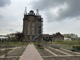
Into the tunnel heading to my destination, Dordrecht.

9F597602-8D9C-49D4-AC05-E2A662168E25.jpeg

Bike safely in room, always good.

66734357-E7BA-42E3-9DDD-AFDDAF49815D.jpeg
And some Dutch tulips.

I’d taken an enormous detour to get here to avoid towns as Im not keen on urban areas.
The rural route I’d chosen proved a challenge And a few more rural days ahead- hoping for better luck on the weather front and non existant ferries.Still good fun though. 54 miles today.
 

Attachments

  • A332F9CE-1B65-4DEC-8394-BA60C0C32076.jpeg
    A332F9CE-1B65-4DEC-8394-BA60C0C32076.jpeg
    228.8 KB · Views: 5

a.twiddler

Veteran
29/4/23 Your Ride today.
The Linear recumbent was still out from earlier so I thought I’d go for a ride just for the sake of it. Still with the front panniers on after my shopping trip I set off through the lanes. I got on to Swanlow Lane heading towards Church Minshull. A gradual almost imperceptible incline yet despite this I maintained a respectable speed (by my standards). A lot of traffic about which though unpleasant in itself gave me a wide berth.

I came to the town limits and the road dropped towards the narrow Ashbrook bridge which marks the boundary between Cheshire West and Cheshire East. A tranche of following traffic had just passed me leaving me free to make the most of the downhill. The road curves with steep banks either side so traffic waiting at the bridge wouldn’t be visible until I got there. I trusted to fate (and my brakes) and pedalled downhill in high gear to get some speed up to get up the other side. Fortunately the traffic had cleared and a solitary car came the other way with plenty of room to pass on the bridge. Plugging away steadily the speed dropped until the final steep bit before the road levelled out again. I’d forgotten how tough this last bit was, and the constant engine and tyre noise from oncoming and passing traffic didn’t improve things. The road levelled out and I was able to regain a more respectable speed.

Despite this there seemed to be cars everywhere. At the end of a flattish straight stetch the road curved left then there was a long steep downhill. The cars behind all passed then I was able to get going in high gear again. Down the hill, up a slight bank, following the winding road into Church Minshull at a good speed. Despite this, again there was a crowd of cars behind me. I came to a chicane with an oncoming car approaching. I was able to nip through with room to spare. A glance in my mirror showed the following cars all stopped to let it pass. A bit of a gleeful moment until I came to the queue for a mini roundabout ahead, when they all caught up again. I turned off in the direction of Nantwich and fortunately most of the traffic turned off in the other direction.

There is quite a concentration of ancient black and white listed buildings in this village, in fact it might be easier to say what isn’t listed. Now that most of the traffic had disappeared I was able to take in some of the ambience as I rolled by. All too soon I was out in the country and climbing a long hill. Not a massive hill climber, but with the selection of gears on hand it was easy enough to find something to match the available meagre output, settle back and twirl. On reaching the top I turned right into Minshull Lane and headed for Cholmondeston. Much quieter now, I was able to just chill a bit while rolling back the miles.

On a slight downhill where the road narrowed and wound about a bit a cock pheasant popped out of the hedge just in front of me on my left. It did a cartoonish double take when it saw me then madly ran ahead on a zig zag course. I simultaneously admired its glorious colours, how well it ran, and considered how getting that bird caught up in my front spokes could spoil the day for both it and myself. Who says chaps can't multi task? Fortunately it disappeared left through a gap in the hedge as quickly as it had appeared.

Soon through Cholmondeston, Wettenhall, then into Darnhall. As I approached the lights at Darnhall bridge they obligingly changed to green so I got a head start on the run up to the other side. Just a short stretch of grinding up in low gear then level. I was soon at my back gate but not far off 11 miles so I went round the block to round it up.

11.1 miles. Max 29.7. Average 8.4mph according to Garmin.
Total Ascent:​
253​
ft​
Total Descent:
253​
ft​
Start Elevation:
192​
ft​
End Elevation:
192​
ft​
Min Elevation:
97​
ft​
Max Elevation:
210​
ft​
According to Bikehike.
46ft per mile ascent
 

chriswoody

Legendary Member
Location
Northern Germany
I was up in the Harz mountains with the family this bank holiday weekend and sneaked in a cheeky ride on the mountain bike. I set of from the campsite we were staying and rode past one of the many small lakes, left over from the extensive mining industries in the area.

P1010821.JPG


From here a short ascent leads on to a 4km descent of over 200m into the adjacent valley, the gravel fire roads are fairly smooth and the descent is rapid. There is a small village at the bottom and I head down the road for a short kilometre before swing South again to begin the ascent of the Hahnskühnenburg. Wide gravel fire roads wind their way around the hillside and I make my way up the steep climb, lungs bursting with the effort.

P1010826.JPG


The forest around me is a mix of traditional woodland and more managed forestry, much of which has been felled. There has been large scale problems here with the Börkenkäfer, a bark burrowing beetle that is devastating the trees here.

P1010830.JPG


After 5km and 450 metres of ascent we arrive at the summit of the Hahnskühnenburg at 807 metres above sea level. The area is heavily forestered though and there are no views of the surrounding area. There is a cafe and observation tower though and there are lots of mountain bikes around. There are many trails around here aside from the ones I'm taking and it's a popular mountain bike area.

P1010833.JPG


After a brief snack I turn around and retrace my steps for 500 metres, ahead of me now lies the "Tante Ju" a mountain bike trail that heads straight down the hill towards the valley I'd started from. It's starts pleasantly enough but soon gets very steep and rooty, I decide I've soon reached the limits of my meagre talents and get off the bike to push some of the sections, no point in risking myself. Other parts of the trail prove a fun delight though and a test of my limited skills.

P1010836.JPG


Then in a small valley I cross a small stream and the trail turns narrow and steep, precariously traversing the side of a steep hill before plunging back down into the main valley.

P1010839.JPG


Whilst the ascent of the main Hahnskühnenburg is over I still need to get back to the campsite and the gravel road ahead is steep and unrelenting. I slowly grind my way up, pausing next to a stream for a snack and enjoying the solitude.

P1010842.JPG


After 4.5 km I crest the top of the ascent and I'm back onto the Plateau and a short sweet bit of single track awaits me before I roll back into the campsite.

P1010843.JPG


Overall a short ride of only 25 kilometers, but with over 850 metres of ascent along with some brutal descent, this has been a long and taxing ride.
 

Glow worm

Legendary Member
Location
Near Newmarket
A 70 miler here today from Dordrecht (NL) to near Uden in the east of the country.
F40925D1-5B50-41DA-9F8C-9D496BEA0DEC.jpeg


Dordrecht is a city on an island, so after a ferry ride off it, I was in De Biesbosch National Park. Miles of lakes, forests and pasture. Heard my first cuckoos, nightingales and grasshopper warblers of the year here. Bliss.

92B35770-F85E-4CE0-B68C-8558843DD157.jpeg


BBDDBEC4-F697-45AA-8F4B-F72421F698A4.jpeg

Although this is a solo tour, it’s nice to have a little company now and then, even if they are after only one thing, in this case, salmon.^_^. such a lovely cat, if I’d had room in my panniers I’d have taken him with me.

7FEF61C9-E5DE-4B98-BF9A-147CDD1C4619.jpeg


Crossing the Maas river.


A175DD5E-C39D-48E6-A16F-44BBDD1AF06D.jpeg

Then Nationail Park number 2, Druinense Duinen. A network of beautiful cycle paths led me through its heart. It reminded me of the dry, sandy Brecks back on my home patch.

EC7119CD-B4D1-4C27-90CA-80AE07A4C215.jpeg

Miles more lanes and tracks followed.

70BF1563-E0A2-4859-8C27-71ABB6C544FA.jpeg


My lovely very rural B and B for the night including beer stocked fridge. Might be a late start tomorrow. It’s ok though only 30 miles planned into Germany.
 

Datum2

Über Member
Location
Huntingdonshire
North Norfolk today, a bike ride starting and ending in Cley. 70 miles and 3000ft of uphill.
Screenshot_20230502_172357_Active.jpg


All that's best about Norfolk roads, quiet, verges not knee deep in Red Bull cans and road surfaces in good order when compared to East Northants and North Cambs.
Picked off Roughton round rower church as this was missing from my list for this area of Norfolk.
20230502_131321.jpg

St Mary rtc
 
Last edited:

Spiderweb

Not So Special One
Location
North Yorkshire
A couple of rides to mention, Sunday on the Tricross with Martin from the next village. Short and Steady with a coffee stop at Cawood Park, 25.36 miles with an average of 14.6 mph.
Todays ride from work was 28.25 miles with an average of 14.2 mph, lovely evening but I struggled in the headwind.

F7EA3169-7431-4C6E-8237-74C9A4858149.jpeg


E0652153-276A-4E70-85F3-512C1FDE7CB1.jpeg


E1A357FB-66AB-418E-8BA0-A2A192BE1D0E.jpeg


F43942D3-A63B-4562-8F9C-B6910C8246F8.jpeg


3C450DFE-D357-4CCB-9DF9-B01CB6777CB2.jpeg


0AAA6687-26EC-46C2-AD06-A5EC3374011B.jpeg
 

Glow worm

Legendary Member
Location
Near Newmarket
A shorter ride here today of 40 miles from near Uden, eastern Netherlands to Walbeck, just into Germany.

Early on, I found myself riding over a ‘Green’ bridge over a major motorway. So well designed, could barely hear the traffic and great connectivity for nature. (There’s a motorway under there somewhere!)

34D13489-243C-44E2-A8B6-790D1E3CE869.jpeg

After miles of blissful riding throug the Maashorst National Park, plenty of lanes like this.

ADE1F17A-E12C-4AFF-BFCB-932112129854.jpeg


A06A8154-A2BB-4D9B-A827-B60FC95E4CDE.jpeg

About halfway, I rode alongside the Maas river (eventually crossing by ferry)

272CA47C-A015-4EFC-AA38-DD90A7843017.jpeg


Another typical road scene from today. This was part of a 7 mile fairly featureless slog until I reached another national park, the Maasduinen.

5D71BE3C-9182-4435-BDC8-C0C9AFCD403A.jpeg

Having crossed the border into Germany, I reached my desination for the day, Walbeck and celebrated with a beer.
B0AD488F-1C00-41D3-BC48-D0D1EE1EAD4F.jpeg


Just a short stroll away, back into Dutch territor, later was this beautiful lake.

C9AD4203-F588-43EB-90A0-CA990BC96F2E.jpeg


Rest day tomorrow to explore Maasduinen park, then I point the bike back west on Friday and begin the ride home.
 

Donger

Convoi Exceptionnel
Location
Quedgeley, Glos.
A Swaledale Soiree: Drove out over Grinton Moor in the late afternoon to get another short ride in along roads I've not ridden before. Only the 12 miles from Reeth to Gunnerside and back, but lovely to finally ride Swaledale at last. Amazingly, I had the whole valley almost to myself, with very little traffic. As I had decided to park up outside a school in Reeth, I had deliberately left it until after the school run to start my ride and it worked a treat. Right from the start there were terrific views out over Swaledale ...
98.River Swale from Reeth.JPG

Although only 6 miles out to Gunnerside and 6 miles back again, this was what I would describe as a lumpy one .... with half of it being up and half of it down. At the top of each of the ups, I stopped for tactical photo ops ...
99.Selfie in Swaledale.JPG

In lovely sunny weather, I don't think you can beat the Dales for scenery ...
100..JPG

Arriving at the turning point at Gunnerside, it was clear that everyone was getting into the coronation spirit and putting out the bunting. In this part of town, though, typical Yorkshire frugality seemed to have taken over and someone decided to recycle this old bunting from when the Tour de France passed through 9 years ago!
103..JPG

I particularly liked Gunnerside. A very quaint little village. I had it almost to myself .... except for a couple of hikers who turned up just in time to improve this photo ....
104..JPG

I carried on down the hill to the bridge over the Swale, to bring up 6 miles and ensure a 12 miler by the time I got back to Reeth. Always nice to finish on a round number.
106..JPG

This ride could be described as "lumpy". In both directions, the biggest climb was up to the ironically (or sarcastically) named "Low Row". On the way back, I stopped in Low Row for another tactical photo op ....
108.Low Row.JPG

Lots of lovely rolling countryside to admire on the way back ...
110..JPG

That's another touristy exploration ride done. Absolutely loved it.
 
Last edited:

Cavalol

Legendary Member
Location
Chester
On Tuesday I got round to riding the new (to me) Trek Madone 2.1, a cheeky little eBay bargain job. The on-line reviews mentioned them chattering over rough roads, but it didn't seem especially bad. In fairness, the last few commutes have been on a mixture of old steel road bikes and a dreadful ancient type ladies bike, so maybe this seemed a treat because of them.

Anyhow, Tuesday was 3.64 miles going in. This, I think, is going to be my favoured commute now, as always like to try a few different routes 'til the best one presents itself.
nc_ohc=XD7LoUQR2C4AX9eaVKd&_nc_ht=scontent.fman4-1.jpg


nc_ohc=NTSDzZfUJaoAX_G6jji&_nc_ht=scontent.fman4-1.jpg

Managed a PB on a section that I hadn't tried to 'compete' on before, so was quite pleased with that. Was motoring along quite nicely, didn't expect it to be good as the traffic lights were red which peeled a lot of speed off.

Going home was a treat, despite being knackered it makes a massive difference on a good bike compared to a cr*p one. A bit like a pleasure ride, rather than a chore. 4.6 miles on this return leg, had a go at Dee Lane climb but a bit off a previous best.

Yesterday I took the same bike to enjoy the journey again. A better attempt at the morning section (8 seconds off the day before) and again hampered by a red light. I think to try and shave a few more seconds off I need to hold off up from the lights and when they change start going for it. Will never get near the KOM, but it's fun trying.


nc_ohc=lSCkZvT_0_gAX_ig7Dy&_nc_ht=scontent.fman4-2.jpg

nc_ohc=i31tAAXyGbsAX9IDiAy&_nc_ht=scontent.fman4-2.jpg


Going home was the same distance as yesterday, again found a route that works well and involves a decent climb for a fat old asthmatic bloke.

Super happy with the Trek, and have some upgrades here for it from another bike. Have found them a very good brand in general, last three or four mountain bikes have been one of theirs (still have the old carbon Superfly) and not had any real problems with any of them.
 

Glow worm

Legendary Member
Location
Near Newmarket
A Rest day here on the German/ Dutch border, to explore the magnificent Maasduinen National Park.

it started well and just got better. This a newly created cycle/ walking path through the forest.
5087F0C1-66D8-4C79-A13E-DC9EC9BA9F0E.jpeg


Some views of the area. Woodlarks, Redstarts and pied flycatchers in song. Overhead, white storks on the thermals. Almost too much to take in. I could have stayed forever.
3821BA80-3DD4-4A88-AC09-587849D2F00C.jpeg


060DC8F0-D1D4-4BAF-8EAB-E6AC317F4B8C.jpeg


There are many lakes and small pools and the pool frogs are very vocal at the moment. This is one of them.

C351C2FD-B55B-4D70-8208-D3742B7F4DB2.jpeg


The Maasduinen is just within Dutch territory, my hotel about 1000 yards into German. So here is the obligatory ‘ bike in 2 countries photo’, rear of bike in Germany at Grenzepost (border post) 499.

C5EB0635-508E-4985-8FBC-54E6A6EC296F.jpeg


6D6B35B2-85EB-470D-8B66-2ED2328EC116.jpeg


And crossing the border further along. Welcome to Germany, Please shut the gate.

0279F455-3EFC-4B4A-83DE-51938FFBB848.jpeg


Pointing the bike west tomorrow for the gentle saunter home. One more national park to go en route the The Hook, then ferry then gloom.
 

Glow worm

Legendary Member
Location
Near Newmarket
Great sunny start, then the storms came.

After crossing back into the Netherlands from Germany, caught the farry across the Maas river heading west

6FC8B949-579E-4A75-8B25-01EC59B99593.jpeg


After 12 miles,I passed this memorial to the British and Canadian crew of Lancaster bomber 123, shot down here in 1943.
864D5C61-5FC8-41D9-AB19-A7A2EA5A48DD.jpeg


CCEE092D-B3F7-4C83-9EBB-2924D99AC063.jpeg

There then followed a series of small towns and villages. I always find these tedious over here because of all the cobbles, narrow streets and idiot drivers. Also the Garmin always gets confused in towns. Its as if after miles of long country roads it suddenly thinks ‘right I’m going to have a bit of fun now’ and starts doing the whole ‘U-turn now‘ nonsense. Luckily I can see through the evil bastard. It’s going in the bin when I get home.

Approaching Eindhoven, (and avoiding it naturally) I skirted along it’s northern edge following some canal or other, hastening pace as the skies darkened. 17 miles in total of non stop 15-20 mph riding. But the rain caught up with me just 9 miles from my hotel on the Belgian border south of Tilburg.

Riding through a decent thunderstorm I find is slightly fun in a masochistic kind of way, and eventually I made it to the hotel, passing a rather attractive Dutch border post on the way (Belgian border).

0F25511E-7A8A-4428-9A31-8D6963D1C215.jpeg


Just a 32 miler tomorrow- hoping for less of a drenching.
 
Top Bottom