
You are using an out of date browser. It may not display this or other websites correctly.
You should upgrade or use an alternative browser.
You should upgrade or use an alternative browser.
National Cycle Network - some paths not very good?
- Thread starter NorthernDave
- Start date
Page may contain affiliate links. Please see terms for details.
Ming the Merciless
There is no mercy
- Location
- Inside my skull
We ought to have a photo thread on crap Sustrans network.
Pale Rider
Legendary Member
We are fortunate in the north east to have several former mineral lines that have been converted into Sustrans paths.
There's not a lot to complain about on the C2C route from Sunderland up into deepest County Durham.
More than 35 miles of mostly off-road, mostly well maintained cinder, gravel or tarmac path.
Same with NCN 1 down the east coast.
Both the paths are also direct, which makes them better for route planning than the roads.
It's even possible to crack on - showing due regard for other users - so it does feel like you are getting somewhere.
Nigel-YZ1
Guru
- Location
- Somewhere else... maybe soon.
Near Wath the powers that be trialed a new surfacing material. It looks like tarmac with flecks of Rotherham Council champagne corks in it.
They must have thought it a success as there's over a mile of it near Penistone.
It's laid rough and is nice and bouncy for pedestrians, but tooth rattlingly rough for cyclists. One of those reactive substances.
Further up its tarmac covered in fine pea gravel.
If they stopped farting about trying to control the usage they may have enough cash to do the job properly.
OP
OP
NorthernDave
Never used Über Member
- Location
- The real Northern Powerhouse
We ought to have a photo thread on crap Sustrans network.
Good call.
I've mentioned this previously, but if I cycle less than a mile from home I can join NCN 66 which will take me all the way to Wetherby.
(For the purposes of this exercise, we'll ignore the fact that there is a significantly shorter route to Wetherby, virtually all on quiet and well tarmacked country lanes).
The first bit of 66 is straight forward on street cycling. It then turns a 90 degree corner onto a rough packed bridleway which is frequently overgrown and unsuitable for a road bike. This deposits you onto a large and busy office / retail park road network.
Across this and then eyes peeled for the almost hidden turning, virtually on the roundabout that takes traffic from the office / retail park onto the motorway.
It's then a shocking poorly surfaced climb up a steep muddy slope onto another bridleway, which has a horse gate thing at the top, then round a couple of narrow turns (hope there are no horses about!) and onto the bridleway proper, which is fairly well packed earth and normally in reasonable condition, the odd few puddles excepted.
This takes you to a junction - NCN 66 turns right over a steeply arched bridge over the M1. (Were you allowed to go straight on and then left you could descend across a field and join another existing bridleway (and traffic free route) to where you're heading, but this missing link is a footpath so no bikes allowed
 )
)Instead you cross the bridge and descend into woods on the bridleway which is a fun ride on an MTB (if there are no peds / dogs about), but again totally unsuitable for a road bike. This brings you out onto a short stretch of cinder road, which soon becomes tarmac and you're then on the road for well over a mile, including a relatively busy section used as a rat run over the motorway (this is also part of the west Yorkshire Cycle Route, something that appears to be a local council initiative and nothing to do with Sustrans).
Eventually you reach a right turn down a farm access road (gated) which is where you'd arrive opposite if the earlier mentioned route was available to you.
Down the smoothly surfaced access road to another gate and you're then onto a rocky rutted bridleway which climbs up and is definitely a no-go for an MTB.
This levels off and continues to be rocky, rutted and potholed / puddled for some distance (still good fun on an MTB) before reaching here:
You can see how muddy it is - and this was after a fairly dry spell. You can just make out where a small stream runs to the side of the route and this regularly overflows.
The route goes through the tunnel which has an inch or two of standing water in it for much of the year, more in winter, and is unlit and curves off to one side so you need lights, no matter how sunny it is.
Out the other side the standing water is normally deeper and muddier and this continues for a couple of hundred yards beyond the tunnel in all but the driest spells.
It's then decent-ish packed earth for a good way, before turning back to a rocky / rutted surface where it drops down into Aberford.
This was the bike at the end of this section:
The route now takes to the road, through the village and then running parallel to the A1(M) for around two miles mainly uphill to Bramham Crossroads, which is a large and busy roundabout where the A64 crosses the A1(M) which you'll need to negotiate at least 4 slip roads depending on your choice of direction.
Shortly after the roundabout you have a choice of staying on the fast road, or taking to the parallel shared path. Bramham is around 2 miles north.
Once in Bramham NCN 66 continues as a shared path separated from the A1(M) by acoustic fencing, with an interesting and unavoidable dogleg on a flinty / rutted farm track, before taking to another bridleway to where the A659 crosses under the A1(M). Negotiate that roundabout safely and it's another shared tarmac path down the hill to Wetherby where after negotiating another large roundabout you're back on the road to get into the town.
So, most of the route on tarmac (and a significant amount of that on busy roads) making it a bind to be on an MTB with knobbly tyres, but linked by other sections that are effectively impassable on a road bike.
And nothing on the Sustrans website (or anywhere else that I can see) to advise what the surface will be before you get there.
Across this and then eyes peeled for the almost hidden turning, virtually on the roundabout that takes traffic from the office / retail park onto the motorway.
I spent the best part of 15 minutes riding around before finding that a couple of weeks ago. :-(
ColinJ
Puzzle game procrastinator!
- Location
- Todmorden - Yorks/Lancs border
I cheated - here it is photographed by the Street View car!I have posted that picture many times but you are the first person to comment on the sign - I was careful to get it in the shot!
Unfortunately, the NCN sign is some distance away so it would be difficult to get both in.
I might have another go next time I cycle over there. To the bottom of it by road, that is! I only tried cycling down once, chickened out, and crashed when I braked...
ColinJ
Puzzle game procrastinator!
- Location
- Todmorden - Yorks/Lancs border
I have plotted a 100 mile route from Garforth up to Wetherby and round in a big loop past Selby and back up to Garforth. I'm hoping to do it on my singlespeed road bike in the Spring. From the sound of it, several of the roads/paths I was going to use are mentioned in your post. I might ask you to take a quick look at the route next year before I do my ride and point out any potential problems. In fact, I might do it as a forum ride and you'd be welcome to come along.Good call.
I've mentioned this previously, but if I cycle less than a mile from home I can join NCN 66 which will take me all the way to Wetherby.
(For the purposes of this exercise, we'll ignore the fact that there is a significantly shorter route to Wetherby, virtually all on quiet and well tarmacked country lanes).
The first bit of 66 is straight forward on street cycling. It then turns a 90 degree corner onto a rough packed bridleway which is frequently overgrown and unsuitable for a road bike. This deposits you onto a large and busy office / retail park road network.
Across this and then eyes peeled for the almost hidden turning, virtually on the roundabout that takes traffic from the office / retail park onto the motorway.
It's then a shocking poorly surfaced climb up a steep muddy slope onto another bridleway, which has a horse gate thing at the top, then round a couple of narrow turns (hope there are no horses about!) and onto the bridleway proper, which is fairly well packed earth and normally in reasonable condition, the odd few puddles excepted.
This takes you to a junction - NCN 66 turns right over a steeply arched bridge over the M1. (Were you allowed to go straight on and then left you could descend across a field and join another existing bridleway (and traffic free route) to where you're heading, but this missing link is a footpath so no bikes allowed
Instead you cross the bridge and descend into woods on the bridleway which is a fun ride on an MTB (if there are no peds / dogs about), but again totally unsuitable for a road bike. This brings you out onto a short stretch of cinder road, which soon becomes tarmac and you're then on the road for well over a mile, including a relatively busy section used as a rat run over the motorway (this is also part of the west Yorkshire Cycle Route, something that appears to be a local council initiative and nothing to do with Sustrans).
Eventually you reach a right turn down a farm access road (gated) which is where you'd arrive opposite if the earlier mentioned route was available to you.
Down the smoothly surfaced access road to another gate and you're then onto a rocky rutted bridleway which climbs up and is definitely a no-go for an MTB.
This levels off and continues to be rocky, rutted and potholed / puddled for some distance (still good fun on an MTB) before reaching here:
View attachment 438448
You can see how muddy it is - and this was after a fairly dry spell. You can just make out where a small stream runs to the side of the route and this regularly overflows.
The route goes through the tunnel which has an inch or two of standing water in it for much of the year, more in winter, and is unlit and curves off to one side so you need lights, no matter how sunny it is.
Out the other side the standing water is normally deeper and muddier and this continues for a couple of hundred yards beyond the tunnel in all but the driest spells.
It's then decent-ish packed earth for a good way, before turning back to a rocky / rutted surface where it drops down into Aberford.
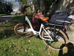
This was the bike at the end of this section:
View attachment 438447
The route now takes to the road, through the village and then running parallel to the A1(M) for around two miles mainly uphill to Bramham Crossroads, which is a large and busy roundabout where the A64 crosses the A1(M) which you'll need to negotiate at least 4 slip roads depending on your choice of direction.
Shortly after the roundabout you have a choice of staying on the fast road, or taking to the parallel shared path. Bramham is around 2 miles north.
Once in Bramham NCN 66 continues as a shared path separated from the A1(M) by acoustic fencing, with an interesting and unavoidable dogleg on a flinty / rutted farm track, before taking to another bridleway to where the A659 crosses under the A1(M). Negotiate that roundabout safely and it's another shared tarmac path down the hill to Wetherby where after negotiating another large roundabout you're back on the road to get into the town.
So, most of the route on tarmac (and a significant amount of that on busy roads) making it a bind to be on an MTB with knobbly tyres, but linked by other sections that are effectively impassable on a road bike.
And nothing on the Sustrans website (or anywhere else that I can see) to advise what the surface will be before you get there.
classic33
Leg End Member
Coming down isn't a problem, it's the 90° left-hander required at the bottom to avoid the wall.I'd like to say that there is nothing wrong with NCN 68 through Hebden Bridge ...
That Chris Froome couldn't cope with on the way up and a kamikaze downhill mountain biker with a death wish would be worried about on the way down!
View attachment 438301
OP
OP
NorthernDave
Never used Über Member
- Location
- The real Northern Powerhouse
I have plotted a 100 mile route from Garforth up to Wetherby and round in a big loop past Selby and back up to Garforth. I'm hoping to do it on my singlespeed road bike in the Spring. From the sound of it, several of the roads/paths I was going to use are mentioned in your post. I might ask you to take a quick look at the route next year before I do my ride and point out any potential problems. In fact, I might do it as a forum ride and you'd be welcome to come along.
No problem. Not sure my legs have got an imperial century in them at the moment, but at least I've got time to prepare!

classic33
Leg End Member
Narrow with no way but backwards down the slope.I like that "Unsuitable for motors" but fine for people who use muscle power. Obviously our safety isn't as important.
The fact they've included raised sets of stones gives an indication of how steep it is.
ColinJ
Puzzle game procrastinator!
- Location
- Todmorden - Yorks/Lancs border
(Speaking from a lot of experience of walking up and down that path...) IF it could be guaranteed that there would be nobody walking about below you (especially with dogs and/or children!) AND there were no leaf mulch on the cobbles AND there were no moss on the cobbles AND there were no dust on the cobbles AND there were no twigs on the cobbles AND the cobbles were dry AND there were no bits of broken down retaining wall spread around the cobbles AND there were no idiot coming up in a 4x4 and getting stuck (I encountered one once, and he had to reverse all the way back down!) AND there were no idiots on motorbikes coming up at you (I encountered one of them once too, but at least he actually managed to keep going and might have got out of your way!) AND there were no parked cars at the bottom AND the road that you would emerge onto were kept clear of traffic AND (ideally) you had a downhill mountain bike ...Coming down isn't a problem, it's the 90° left-hander required at the bottom to avoid the wall.
... THEN you would stand a reasonable chance of getting down in one piece as long as you didn't get scared and brake too suddenly!

Last edited:
snorri
Squire
- Location
- East coast, up a bit.
If you had said crap National Cycle Network I would have supported you, but trying to differentiate between the parts maintained by Sustrans, local authorities and trunk road contractors makes the task quite tiresome and can only result in controversy.We ought to have a photo thread on crap Sustrans network.

classic33
Leg End Member
There's a chance you could make it doen then.(Speaking from a lot of experience of walking up and down that path...) IF it could be guaranteed that there would be nobody walking about below you (especially with dogs and/or children!) AND there were no leaf mulch on the cobbles AND there were no moss on the cobbles AND there were no dust on the cobbles AND there were no twigs on the cobbles AND the cobbles were dry AND there were no bits of broken down retaining wall spread around the cobbles AND there were no idiot coming up in a 4x4 and getting stuck (I encountered one once, and he had to reverse all the way back down!) AND there were no idiots on motorbikes coming up at you (I encountered one of them once too, but at least he actually managed to keep going and might have got out of your way!) AND there were no parked cars at the bottom AND the road that you would emerge onto were kept clear of traffic AND (ideally) you had a downhill mountain bike ...
... THEN you would stand a reasonable chance of getting down in one piece as long as you didn't get scared and brake too suddenly!