Whats my options for mapping a route

Page may contain affiliate links. Please see terms for details.

jiberjaber

Veteran
Location
Essex
So ive had a little play with all of them and so far i like kamoot the best, the free map covers where i wanted to go on the weekend so thats a bonus, £9 for extra maps or 20 for the whole world is good too.
The mapping is a little frustrating tho, it just wont let me go down some rds which other apps will, it wants to send me a long way round.

Ride with gps £75 for premium member! Deleted once i saw that lol
As Marky says - you only need the middle subscription... also you (even with the free version) have access to different map layers which offer different takes on routing and visable land features plus the ability to use the Google pin man to check street view (which will go some way to confirming the conditions of the street /route/path you wish to use).

Komoot is good (I have the full works on that also) but limited on level of zoom and only using Open Street maps, which are good but sometimes conflicting with Google maps and ignorant sometimes of true rights of way. Other bonuses are the visualisation of the road surface but often it is only as good as user contributed.

The best solution overall for actual planning is combining both plus the definative map of the area you wish to use. For navigating on the bike it does seem Komoot is probably the winner.

This chap has done a really good job at bringing all the PROW definitave map data in to one easy place http://www.rowmaps.com/
 
Location
España
Just to offer an alternative....OSMand.
It's free (at least the first 5 maps are -that'll cover the UK at the very least), has turn by turn navigation and has a lot of possibilities for marking Points of Interest or importing ones. It can be used for hiking, biking or the car too.

It is not the most user friendly option - it takes a while to get used to - but in my opinion is well worth the time it takes.

It is the only mapping app (that I know of) that allows you to plot a route offline and save it.

I always find it helpful to consider the planning of the route differently to following the route. OSMand is for following (and in emergency for plotting).
Pair it with https://cycle.travel/map to plan the route and you are on to a winner. Cycle travel is especially useful for planning loops - specify the distance and it gives you 3 options.

No matter what app you are using, planning your route is better done on a computer. Phones are too small in my experience.

And, if using your phone to follow the route make sure you have a good holder and some kind of protection against sun and rain!
 

jiberjaber

Veteran
Location
Essex
Just to offer an alternative....OSMand.
It's free (at least the first 5 maps are -that'll cover the UK at the very least), has turn by turn navigation and has a lot of possibilities for marking Points of Interest or importing ones. It can be used for hiking, biking or the car too.

It is not the most user friendly option - it takes a while to get used to - but in my opinion is well worth the time it takes.

It is the only mapping app (that I know of) that allows you to plot a route offline and save it.

I always find it helpful to consider the planning of the route differently to following the route. OSMand is for following (and in emergency for plotting).
Pair it with https://cycle.travel/map to plan the route and you are on to a winner. Cycle travel is especially useful for planning loops - specify the distance and it gives you 3 options.

No matter what app you are using, planning your route is better done on a computer. Phones are too small in my experience.

And, if using your phone to follow the route make sure you have a good holder and some kind of protection against sun and rain!


Good shout on the offline capability - I thought that was available in Komoot and just tried with my phone in airplane mode and it wouldn't plan!

cycle.travel is also very useful for finding the least trafficed and flattest route (or at least a starter to work from). It uses a precompiled dataset of traffic volumes to do that which is a good feature..

I think the collective takeaway from all this is that there are many tools and getting the right blend of all of them is the ideal but it all depends on your intended use case :smile: For me I feel there will never been a dot-it-all solution.
 

KneesUp

Guru
Actually - from memory the route planning in Komoot is done by their servers - I suppose it's much faster to send the instructions to plot a route to a proper computer and get the answer back than to plot the route itself. I believe that's how google maps etc work too. I You can mark a pre-planned route as available off line and it will then do that without a data connection as long as you have GPS.
 
Airplane mode turns off GPS doesn't it? Not sure how any device doing navigation would work without that?
No, or at least it shouldn't. Airplane mode disables any transmission data and phone calls./ GPS should simply receive the satellite signals so can do so without sending anything out. Some phones also use local arial triangulation to enhance or speed up GPS so it wouldn't be able to use that which might very slightly slow down the speed in which it locks onto your initial location but it's not really a problem.
 
Location
España
Actually - from memory the route planning in Komoot is done by their servers - I suppose it's much faster to send the instructions to plot a route to a proper computer and get the answer back than to plot the route itself. I believe that's how google maps etc work too. I You can mark a pre-planned route as available off line and it will then do that without a data connection as long as you have GPS.

I've had issues with Google Maps in offline mode.
Coming from a touring background, I'll often save the area I'll be travelling in on Google maps, marking off useful info such as campsites etc. However, in reality, in the sticks with phone data off and no wifi anywhere available I have found Google Maps places my actual location in the wrong place. Now, maybe that was my phone at the time, but they do say it's accuracy is improved with data and by scanning local wifi networks.

Having played around with most of the apps discussed above, you're right in the sense that you can use routes previously created if you specify. However, issues can arise if you go off course.

As @jiberjaber says...
I think the collective takeaway from all this is that there are many tools and getting the right blend of all of them is the ideal but it all depends on your intended use case :smile: For me I feel there will never been a dot-it-all solution.

Intended use is the key thing.
For me, touring in strange places, an offline mapping ability is essential. For someone who wants to pootle around the locality that is far less relevant.

And for any app, give them a good test before relying on them 100%. Try going off course. Check battery usage and any battery saving features. Try routes that cross themselves -eg a figure 8. Try them in urban areas that you are familiar with before unfamiliar cities.

My current phone leaves the gps on when in airplane mode.
 

KneesUp

Guru
No, or at least it shouldn't. Airplane mode disables any transmission data and phone calls./ GPS should simply receive the satellite signals so can do so without sending anything out.
You are of course correct, and it turns out I thought the 'Mobile Data' icon on the quick settings page was GPS all this time. In my defence, the last time I flew I had a Nokia of some description, so it's not a mode I use much :smile: Interesting my phone (iphone 5s) leaves wi-fi on when you select Airplane mode.
 

Ming the Merciless

There is no mercy
Location
Inside my skull
Depends on the phone. In airplane my phone turns all the above off. But if I wish to turn on wifi or Bluetooth or GPS when in airplane mode that is fine. You just turn it back on. GPS is not normally active on my phone anyway.
 
OP
OP
gazza81

gazza81

Über Member
Location
Edenbridge
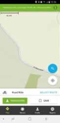
Haha no definatly roads Screenshot_20190129-122657_Komoot.jpg
Like this one it wont let me cycle on but its a tarmac road
 
D

Deleted member 26715

Guest
I only say that as many many years ago, (late 70's probably) we were stuck on the A1 coming south somewhere around York, I handed the map to my wife (then girlfriend) saying "had enough find us a different way home" she found the page we were on, then the page where we needed to go to. The first comment was "There should be a turning coming up on the left, if we go down that little black road for a little while then turn right down this blue one we should get home a lot easier" Once explain what the road colours meant she changed her mind.
 
Top Bottom