Whats my options for mapping a route

Page may contain affiliate links. Please see terms for details.

jiberjaber

Veteran
Location
Essex
To clarify - as it seems to have set some hares running!

I turned the phone to airplane mode to remove any internet/data connection - i.e. true offline planning. Nothing to do with GPS :smile:
 
OP
OP
gazza81

gazza81

Über Member
Location
Edenbridge
Change your method travel to 'Touring' or whatever it's called.

Nope that wont do it either, its like a glitch. It stops half way down the rd and it i try and go further it takes me back on myself all around the block then back up the rd it wont let me down!!!

Well i think ill stick with this one and just follow the route it plans for me as it'll do for the time being and its costing me nothing
 
D

Deleted member 26715

Guest
I've not found a 'proper' mapping system yet, I use bridleways mainly & come across this problem regularly with them all
 
Location
España
Nope that wont do it either, its like a glitch. It stops half way down the rd and it i try and go further it takes me back on myself all around the block then back up the rd it wont let me down!!!

Well i think ill stick with this one and just follow the route it plans for me as it'll do for the time being and its costing me nothing
Try planning the route you want using the road you want on cycle.travel. Export to GPX/TCX, then load it into Komoot.
 

KneesUp

Guru
Komoot, like OSMAnd, is based on Open Streetmap data, which is what makes them affordable. If you spot errors, you can submit corrections to make it better for others (and you if you regularly plan routes that are 'wrong')
 
OP
OP
gazza81

gazza81

Über Member
Location
Edenbridge
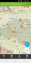
Well playing with it a bit more and there is grey areas, the road it wont let me down happens to be a boarder road on the grey bit, just dont know why or what the grey sections mean!?!? Screenshot_20190129-135920_Komoot.jpg
 

jiberjaber

Veteran
Location
Essex
Well playing with it a bit more and there is grey areas, the road it wont let me down happens to be a boarder road on the grey bit, just dont know why or what the grey sections mean!?!? View attachment 449617


Can you zoom in a bit more or use the web app to show exactly which bits you are referencing?

I think the bit you are refering to is the area High Weald AONB?

Sometimes there are disconnects in the map data which the routing algorithm are unable to route along but either local knowledge or another map layer shows that the route is indeed routable...
Sometimes these disconnects are either path not drawn to connect or change in path type (footbpath vrs cyclepath) or a one-way road which is actually not one-way for cycles... (just some examples of course :smile: )

ETA: This might help? https://www.openstreetmap.org/key
 
Last edited:
OP
OP
gazza81

gazza81

Über Member
Location
Edenbridge
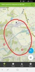
This is zoomed in to the boarder, the road running down the middle is the one it wont let me down and the lake to the right is where ill be heading.
20190129_151446.jpg

The grey areas are scattered all over the map not just my local area but cant find anywhere explaining what it actually means!!
 

KneesUp

Guru
The shaded bit is a National Park or similar - High Weald AONB as @Jibberjabber says.

upload_2019-1-29_15-21-15.png
 

jiberjaber

Veteran
Location
Essex
Yep - Confirmed Komoot won't (by default) route along Ensfield Road on to The Tudor Trail - even trying to add waypoints don't resolve to take that route. It's not linked to the map layer or to the "Follow Ways" on/off option so must be something in their routing engine.

upload_2019-1-29_15-37-12.png


RWGPS with OSM Cycle (and google maps) does route along the road though:

upload_2019-1-29_15-38-58.png


cycle.travel also routes along there too:

upload_2019-1-29_15-40-11.png
 

Bobario

Veteran
When you click to add a waypoint, there is a tiny circle in the bottom left of the dialog box "follow ways". If you untick this it should let you plot a series of straight lines till past the point it doesn't want to route you through. Then click the same thing to turn autorouting back on. This is assuming you are using a computer not a phone app.

Gah! Sorry didn't read your previous post before replying. But I've just plotted your route in short sections and it worked fine.
 
Last edited:
OP
OP
gazza81

gazza81

Über Member
Location
Edenbridge
Having a play on the lap top now im home, its much better although still easy to use on phone.

I really like the little points of interest you can set as a destination.

So if i plan a route, put phone on airplane mode and follow the route, then i decide to stay out longer with it register where ive been?
 
Last edited:
OP
OP
gazza81

gazza81

Über Member
Location
Edenbridge
Well been using kamoot for a few weeks now and i must say its been spot on!
I just turn my gps off to save batt and the screen turns off an wakes up when giving directions.
Guess it uses around 10% per hr which i can live with.
Wont be using anything else for the time being!
 

LeetleGreyCells

Un rouleur infatigable
I have been intending to get the full mapping but can't see it less than £29.99 anywhere?
I live on the border between two regions so had to pick one as the free one so now I can only ride north of home with navigation while I try Komoot out. If I like it then I don’t mind paying out, but I too would like to pay less that £30 for all regions if anyone has a discount code or similar.

I did my first ride today using Komoot, a utility ride to collect some wood screws from Screwfix so perfect for testing the app. I turned the screen off on the outbound journey but only heard approx. half the cues on full volume. Riding back, I left the screen on which used 13% battery in 11 minutes. I’ve got to work out a way of hearing the audio cues - I won’t wear headphones cycling on the road. Maybe a single earpiece? I don’t really like the idea of that though.
 
Top Bottom