Your ride today....

Page may contain affiliate links. Please see terms for details.

Jenkins

Legendary Member
Location
Felixstowe
Interesting picture, @Jenkins. Could be the first in a "Your bike in front of a crinkle-crankle" thread. I once attended a lecture on surveying and mapping in which the subject of this almost mythical beast came up. For professional purposes, I kept a small file of photos as examples to pass on to colleagues .... who invariably thought I was pulling their leg when the name "crinkle-crankle" came up! I seem to recall that the East of England is the epicentre of the crinkle-crankle construction world .... something to do with economising on bricks, I believe, with structural strength of thinner, cheaper, walls being improved by wavy (or sometimes crenelated) construction. This shot of yours would have been the holy grail for cartography training purposes, and would quite likely be depicted on an Ordnance Survey map as a single continuous curve parallel to the road:
View attachment 492601
Here endeth today's lesson. Cheers, Donger.
In that case I can add another crinkle crankle wall to your file. This is from a ride last year and is at Bramfield, also in Suffolk. And from what I read up at the time, it means that a fairly strong wall can be built from a single skin of bricks .
Bramfield crinkle crankle wall.JPG
 
In that case I can add another crinkle crankle wall to your file. This is from a ride last year and is at Bramfield, also in Suffolk. And from what I read up at the time, it means that a fairly strong wall can be built from a single skin of bricks . View attachment 492671
I`d never heard the expression of a crinkle crankle wall, I`d always known them as serpentine walls. Something I`d picked up from my parents I guess as well as my wife, both Suffolk born. Nice photo by the way.
 

jongooligan

Legendary Member
Location
Behind bars
Mixing it up again today with a ride on my cyclocross bike. Got out early before the forecast rain arrived and retraced yesterday's route to Black Boy Road where I got onto the bridleway.

The tracks around the perimeter of Rainton Meadows nature reserve are a mix of deep mud and hard packed crushed brick. Both surfaces are a lot of fun. I really enjoy the challenge of staying upright in the mud as the back wheel slithers around. It was all over too soon and I was back on Black Boy Road where I had a bloody visitation. Oh the joy of replacing a tube with the tyre covered in mud and the rain, now having arrived, was coming down sideways in a strong wind.

Back on the bike and through Fencehouses to find the path at the Floaters Mill. It's a footpath but well surfaced and I thought it unlikely I'd meet anyone in such foul weather so went for it. Good choice as it was a clear run to the Smiths Arms where I took to the road for a short stretch before dropping into Castle Dene. Bad choice as this is also a footpath which is a mix of deep mud, slimy rock, gnarly tree roots and dog walkers. Decide I won't be going that way again as I shouldered the bike and trudged out of the woods to Ropery Lane.

This is a continuation of Ropery Lane which runs through Chester le Street. This section runs around the back of Lumley Castle and through the golf course. I think it maybe private but I've never been stopped on it and so it was today.

A loop around the riverside and through the park then over the A167 to climb through the town and I was home. Soaking wet, covered in mud and a bit chilly but happy with another 15 miles in the legs.

1573555972533.png

No pics again today as it wasn't the weather for hanging about and my hands were too mucky to handle my phone.
 

Jenkins

Legendary Member
Location
Felixstowe
Last day of the long weekend off work and time for a quick shopping trip to Ipswich to pick up a remote light switch from Halfords. As is usual, I didn't exactly take the most direct route, going on a loop out to Holbrook and Alton Water, then up to Capel St. Mary before heading in to Ipswich from the far side.

It was a bright & sunny morning, but a keen and cold wind was blowing from what seemed to be all directions and I've not spent so much time spinning on the inner ring just to maintain a bit of speed on the outward bit. Added to which there was a rain band approaching from the North West and that caught up with me just after taking this pic of the River Gipping in Ipswich (combination of duckweed & leaves on the surface)
River Gipping - Yarmouth Road.jpg

The result was a quick dash for cover in a pub and a most welcome pint while waiting for the rain to pass. I now need to give that bike a quick clean tomorrow morning as it's my main commuter and looks to have gained quite a bit of weight in the form of road muck!
Screenshot_2019-11-12 Cold, windy wet - back to normal Ride Strava.png
Screenshot_2019-11-12 Cold, windy wet - back to normal Ride Strava(1).png
https://www.strava.com/activities/2859785833
 

Old jon

Guru
Location
Leeds
Out on the fixed today, the morning was bright and sunny. And F f f f freezing! Well, two degrees or thereabouts, and the birdbath was ice free.

Jack Lane into Holbeck, find Water Lane and ride under the wings to reach Great Wilson Street. Left onto Crown Point Road and across the river. I should have warmed up by this time, a couple of miles or so but no. Pedal a bit harder, reach Roundhay Road, which starts rising, levels a bit and rises again. All the way to the Oakwood Clock. And still cold. The next bit is Boot Hill and I could not see me riding up that, reaching this far had been difficult enough. So, it took five miles to here and oddly only four and a bit to return home. Which I was very happy to see, for no change at all.

The map loop is around the clock, included to show the garthing’s resolution. Shows my track on each side of Roundhay Road. Well, it impresses me anyway.

13112019.jpg
 

twentysix by twentyfive

Clinging on tightly
Location
Over the Hill
Mrs 26, Jules H, Margaret PR and Rich B today. So 5 today is quite a turn out midweek. Flooding had to be considered on our routes today so we had to go by Longdon as the school would be problematic. Tewkesbury was still dry but water was everywhere. Up on the flanks of Bredon Hill was as usual. Nicely drained. We took a little loop up to Grafton for a change. Something I'd only done once or twice but no one else had. On the run to Dumbleton a Red Kite was spotted. It circled us a while presumably looking to pick off the weakest. The sign said Broadway to the right but I lead everyone straight on. Mrs 26 wondered...... So for a change we went by the back way through Childswickham before setting ourselves up in the Tea Leaf Cafe in Broadway.
We had a little look at another cafe at the other end of the arcade before retracing to Childswickham and on over Hinton Cross for Elmley Castle. Now would Eckington Bridge be cutoff in the floods? That would put a big detour in if it was so we opted to cross the very swollen Avon at Pershore. Then it was a run along Rebecca Road for Croome, Kinnersley and Upton where we parted. Mrs 26 had the car so me on my own dodged the floods again to get onto the Brotheridge Green lane. Lovely sunny day today. Very pleasant outing indeed. 69 smiles
 

jongooligan

Legendary Member
Location
Behind bars
Where to go this cold but sunny morning?

Inland, to the west, are treacherous frost hollows where pools of cold air gather to turn water hard as stone. Icy traps lay in the shade at the bottom of the denes ready to unseat the reckless. But to the east the benign effects of the North Sea would ensure there wouldn't be any ice. So a ride to the seaside it was.

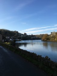
Started with a chilly descent to cross the River Wear at Lumley Castle but generated enough heat on the climb over Warden Law to stay warm on the way down to Seaham.

20191113_121707[1].jpg

Tommy

This Ray Lonsdale statue, titled '1101' to signify the first minute of peace after the armistice was signed, is also known as 'Tommy'. The pebbly mosaic around the base is a recent addition for remembrance day. I'm not sure whether that's permanent.

At the top of Dalton le Dale I'd only done 15 miles but with a late start I was ready for something to eat.

In the shop at Easington a mother and daughter were filling a couple of baskets with stuff directly in front of the sandwich shelf. The mother apologised as they moved away.

'No problem.' I replied, 'I've got nowhere to go and all day to get there.' I bit back those words as they got to the till just before me and launched into a long discussion with the cashier about the availability of particular brands of fags. When the cashier realised that the till hadn't registered any of the shopping she had scanned and she'd have to start all over again I put my lunch on the coffee machine and legged it. I was bursting for a pee.

Ironic then that a couple of weeks ago I'd decided not to visit Shotton Colliery, Wingate or Station Town again as they are so dismal but now found myself heading that way in search of food. Sitting in the sunshine eating a chicken wrap at Shotton Colliery made me realise that maybe it's not such a bad place after all.

On the way to Deaf Hill the sun hid itself behind a thin band of cloud. Straight away it was so cold my eyes were watering. I was looking at the world through the wobbling lens of a tear quivering on my lower right eyelid. I blinked it away. Immediately another took it's place. The world would have to stay wobbly for a while but I needed to stop to put my windproof and gloves back on.

By the time I got to Coxhoe the sun was out again so I stopped to take them off and took this picture.

20191113_140643[1].jpg

Coxhoe Colliery Headgear Wheel

County Durham is littered with these colliery headgear wheels, often used as memorials to the miners killed in the pits. I might try to find them all. It would make a good theme for a tour.

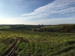
Easy riding through Sherburn brought me to the A690, where I had a three minute wait to get across, followed by the drop down to cross the Wear at Cocken Bridge for the second time this week. Got across the A167 without a wait and then climbed through Nettlesworth to Daisy Hill for a descent across Waldridge Fell.

I noticed our car at Waldridge country park and immediately hatched a cunning plan. Mrs. jg would be walking our mutt. After walking the mutt Mrs. jg always puts the kettle on so if I could time it right I'd arrive home just in time for a cup of tea. Instead of taking the direct route home I dodged down Waldridge Lane to Chester Moor.

20191113_152116[1].jpg

Spotty Horse at Chester Moor

Then I looped around the new road and was overtaken by Mrs. jg about a mile from home. Perfect!
1573667859834.png

An enjoyable 51 miles with 2,650ft of ascent.
 
Last edited:
Weather reasonable but cold, by my standards anyhow. Decided to just hit 27/270 as usual and see what transpired. Got to Plymbridge Station, so a biggish one for me. Going that far toward Plymouth is exhilarating, as it's basically all downhill from Clearbrook. And, naturally all uphill on the way back...
I needed the climb in my legs, so just got on with it.
Cold...feet and undercarriage pretty numb by the time I got back. Sleet threatening also.
28.11 miles, 9.9mph, 2121ft of elevation gain, and a top speed, apparently, of 65mph...
I think Map My Ride gets confused in the tunnels!
:biggrin:
Edit: still using the Scott roadie, shoulder barely complaining at all now. I'll be thinking if London to Brighton on it next June, I reckon.
 

jongooligan

Legendary Member
Location
Behind bars
We seem to be living under a huge grey duvet in the north east recently but a glimpse of sun tempted me out today even though we'd had some spiteful hail showers when walking the mutt.

The wind was north eastish so that's the way I went so that I could turn my back and come home if there was to be more hail. Followed white van man through Chester le Street as he ignored all the traffic restriction signs then carried on up the old A1 to Birtley. It was a relief to leave the main road and drop into the Team Valley. Left and left again at Lamesley then past the Ravensworth Arms and right for Kibblesworth to look for the old pit headgear wheel. And here it is.

20191115_140554[1].jpg

Kibblesworth Colliery Headgear Wheel

The plaque on this one marks the closure of the pit in 1974. In the background is the CIU club. Not many of these left open now.

Now for the climb of Kibblesworth bank. Was climbing really easily when it occured to me that the wind was right behind me. Probably shelve the idea of a comeback to racing then.

Turned downhill on Birkland Lane and started to enjoy swishing through the deep puddles until I saw a car speeding towards me kicking up a pair of watery rooster tails and an impressive bow wave. He didn't slow down and as he passed it was as if someone was hurling buckets of water at me. Think TISWAS if you can remember it.

Soaked now, I realised that with this much surface water about the bridge at High Handenhold would be impassable so took Cranberry Bog Lane to the bottom of Hammer Square Bank, which is often used as Sunderland Clarion's hill climb course. It's steep, the surface is very rough, it's slathered in chippings, rotten leaves and horse muck, it's running with mucky rainwater but I'm getting up really easily. Ah, the wind is on my back again. It's almost as if I'd planned this route (I haven't).

At the top there's no time for a pint in the Shepherd & Shepherdess.

20191115_142350[1].jpg

Shepherd & Shepherdess

Those figures are reputedley made of lead - something to do with dodging a weapons blockade in the Napoleonic Wars.

Took the underpass to cross the A693 which brought me to West Pelton and today's second headgear wheel.

20191115_143159[1].jpg

Colliery Headgear Wheel at West Pelton

This one is now incorporated into Roseberry Grange golf course. It was here that I first beat my owd man at golf, about 30 years ago. I've never picked up a club since.

Now up Bluehouse Bank and onto Humbleburn Lane into Holmeside where I turned for home with my usual crossing of Waldridge Fell. Just 18 miles with 1,100ft of ascent.
1573838607411.png
 
Last edited:

Old jon

Guru
Location
Leeds
Time to try again, after last Wednesday’s short escapade. Warmer this morning and dry when I pedalled the geared bike down the street.. The street does not have a down, being as near as dammit level, so maybe I should have typed ‘along’ instead . . .

The clock at Oakwood is still five miles away. Approaching that the thought struck. ‘Why do I ever think the next hill can be easy?’ Optimism I guess, and Boot Hill took a bit of riding up this morning. Even with gears. Just after the top, turn right. This is Red Hall Lane, then Skeltons Lane which makes the upright of a ‘T’ when it meets Thorner Lane. Turn left there, towards Thorner. This bit is mostly downhill and is where my friendly rain cloud said ‘Hello!’ this morning. Never mind, ride most of the way through the village and turn left onto Milner Lane. This goes out of the village, up a sharp little hill to a junction with the second Thorner Lane of the day. Sometimes I am happy I was never a postman. Still, a right turn to East Rigton, lovely road, shame about the view of the rainclouds, and right again at Rigton Green. Which I think is Compton Lane.


And then down Jewitt Lane to Collingham and the A58 again. Turn left on this, for a short bit, and then right on to the A659. This road is everywhere, in sections. Otley to Harewood Bridge. Gap. Harewood to Collingham and then with another gap Collingham to Tadcaster. It likely goes further, but not for me today. Riding the middle bit towards Harewood, the road rises for a fair distance then drops to the left turn for East Keswick.

This is really a great road. More fun in the other direction ‘cos it is easier downhill. All the way to Slaid Hill, up and down the gears and happy to see the traffic lights there, left turn to Shadwell, downhill again. Gatehouse Lane on the right, for another return to the A58. Right again. There is a great view as the Ring Road is approached, at least as far as Emley, I suppose the rain clouds were hiding Wakefield and Dewsbury this morning. Down that hill again now, and turn at the bottom towards Oakwood again. Then the urban navigation to take me home again after twenty nine miles, and 1700 feet of up. Happy with that.

Random lines produced by bicycle

16112019.jpg
 

geocycle

Legendary Member
Looked better weather in the west so headed to Lakes rather than Dales. Took a lovely new Northern train to Ulverston then cycled up the fantastic east side of Coniston, over Hawkeshead hill to Esthwaite and then ferry across Windermere before riding home. Pictures are Esthwaite Water, Coniston with snow on the Old Man (!), a coffee stop at Brantwood with a view, Esthwaite Water then Windermere from Ferry. Not bad for November.

493082


493083


493085
493084
 
Top Bottom