Your ride today....

Page may contain affiliate links. Please see terms for details.

Fredo76

Über Member
Location
Española, NM
631967


Rio Grande from NM 502
 

Ian H

Ancient randonneur
Richard and I had a hotel booked in a Salisbury for Postie's reunion, though the storm warnings were ominous. My route there included the old turnpike from Shaftesbury to Salisbury, a ridgeway above the Fovant Emblems. This started not too badly but then became muddy, tree-strewn, and in places unridable. We and the bikes were caked in mud when we arrived after 123k. Kudos to Wetherspoons, they didn't bat an eyelid and our bikes went in a secure room upstairs. The breakfast Sunday morning was still crap.
632004


632005

632006


The homeward journey was via the Wylye Valley into the teeth of gales-force winds. There was tree debris everywhere and it was slow, exhausting progress. Fortunately we only found one tree across a road, and easy to get through. 133k took us over 9hrs.
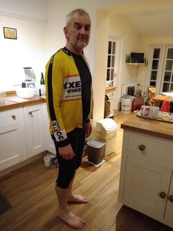
E decided a photo of exhausted me would be amusing.
632007
 

Rickshaw Phil

Overconfidentii Vulgaris
Moderator
I haven't been on the bike for over a week again due to a mix of things to be done and the grotty weather we've had. Today wasn't brilliant either with strong winds but it was dry and didn't seem too bad by the afternoon (the Met Office appears to have a different opinion of that :laugh:) so I went out anyway.

It was just a short one to go and see how the river levels had come up after all the rain that storms Dudley, Eunice and Franklin had dumped on us. The underpass at Meole Island was flooded pretty well, but that tends to flood after most storms so not a surprise.

Riding down to Coleham Head I had to pass two sets of temporary traffic lights but didn't see any of the usual warnings about the road being closed due to floods (which I knew it was by now). The result was chaos as a steady stream of vehicles was headed down, only to find the way barred and that they had to turn back.

The water was out at Coleham Head and rising along Longden Coleham but not yet as high as I know it can get. A couple of guys in a Freelander had made a point of ignoring the closure from the Longden side coz they've got a four wheel drive and it can take a bit of water:rolleyes:....... only to find a four foot flood barrier blocking the road they wanted to take next. What, no levitate button? :whistle:

Moving on, the water hadn't got anywhere near the access to Greyfriars footbridge so I used that to get into the centre and had a tour round the usual spots that the water gets to. Amazingly nobody had left their car to be drowned in the St. Julian's car park, or any of the other car parks that have flooded either, as far as I could see. That must be some kind of record.:ohmy:

As is often the case, people become chatty when there is something like this going on so I'd had a few conversations en route through the Quarry, round to Victoria Quay, into Frankwell then back into the town centre to make my way round the blockages of Smithfield Road and Raven Meadows.

After getting to Castlefields I did think about riding to Atcham but changed my mind and thought I'd go back to Coleham and see if the water level was noticably different. It was, which shouldn't be surprising as the river isn't expected to peak until sometime tomorrow morning.

At the time of writing this, 4.9 metres above normal is the latest measurement - extremely high and a full 30cm higher than when I was in town.:ohmy: It's possible that it will go beyond the existing record of 5.25 metres set in November 2000, but I know the height forecasts can be way out so I shall be interested to see where it ends up.

12.6 miles for this one at a sightseeing pace of 7.5 mph average (lots of walking involved).

632044

First visit to Coleham Head and anyone would think the road was closed.:whistle:

632045

A riverside property is lovely much of the time but not when the river wants to come in and share.

632046

Crescent Lane is definitely a no through road today.

632047

Hercules has become part of a new water feature.

632048

The Armoury's diners would have kept their feet dry when they went in. Fortunately there is a back door which the water shouldn't be able to reach....... not yet anyhow.

632049

The steps on Frankwell footbridge giving a good idea of how quickly the water is moving.

632050

Smithfield Road is usually one of the busiest streets in the town centre.

632051

Raven Meadows.

632052

Chester Street. Not much chance of getting out of town that way.

632053

I've worked my way back round to Coleham Head and not only is the level visibly higher than an hour or so ago but it's fountaining up through the drains.
 

Alex321

Veteran
Location
South Wales
First time on the bike since last Tuesday today, thanks to the wheather..

Was in the office today, but it was still much too windy to take it this morning, so drove in. Wind started to ease off after lunch.

By the time I got home, it was almost calm, so I decide to go for a quick spin fter dinner. All in the dark, but mostly dry, and no noticeable wind, with a temperature of 4C meant quite a pleasant ride.

Just took one of my regular rides, out through City - Langan - Colwinston - Llandow - Llysworney - Cowbridge (stop at Tesco for some chocolates for my wife) - Aberthin - Maindy - Home. 15.68 miles, 1168 feet elevation, at an average of 16.2mph.
 
Last edited:

AndreaJ

Veteran
A very short ride today before work because I wanted to test ride my new bike, it’s been sitting in my kitchen since Saturday evening and I am not good at waiting. I wasn’t able to test it at the shop which is in Shrewsbury as they send you to the Quarry which wasn’t quite as bad as @RickshawPhil’s pictures from today but was already flooded.
It actually stopped raining and the 45mph gusting wind had dried the lanes off so I did a short circuit into Northwood and home. It was too windy really but I am pleased with the bike and looking forward to going on a proper ride with it. Only 5.9 miles and it’s still clean! Speed varied wildly depending on which way the wind was blowing 😂
 

Rickshaw Phil

Overconfidentii Vulgaris
Moderator
The river level peaked this morning, just 10cm short of the record, and after waiting for a band of rain to go through I went down to town again to see how high the floods had come since yesterday.

Shrewsbury is all but cut off today with only Kingsland Bridge open to inbound traffic. As a result the traffic on the routes around town was pretty congested and a bicycle was a much better option for getting around. To start with I headed to Sutton and into Coleham along cycle routes then back and around to Abbey Foregate before heading for Castle Walk footbridge. Approaching the bridge on the cycle path I hadn't expected to find it flooded part way along. Fortunately the adjacent footpath is a few feet higher higher so after scrambling up to that I was able to get to the bridge on dry ground.

After seeing what there was to see in Castlefields I headed for Castle Foregate which is closed under the railway bridges where the water is well across the road. There is pedestrian access just about so I made my way past the station for another photo stop at the end of Chester Street.

Heading up Castle Street I found the council had taken the opportunity to do some drain cleaning while there is no traffic - a blocked road and it's been leaking oil all the way up the hill. It was really nice riding downhill along Dogpole and Wyle Cop without any traffic other than cycles, although a bit of care was needed because that lack of traffic has made people prone to stepping into the road assuming nothing is coming.

More photos at the bottom of Wyle Cop and St. Julian's Frairs before making my way along Town Walls to The Quarry then Victoria Quay. A quick look at Frankwell made me realise that had the forecast level of over 6 meters come off it would very likely have overtopped the defences here. I had a look at Roushill and Raven Meadows then headed out of town across Kingsland Bridge and dropped into Coleham for one last look before retracing my steps home via Sutton and Meole Brace (traffic still queueing).

13.2 miles at 8.5 mph average.

632247

Coleham Head. I couldn't get anywhere near where I took the previous photos. The canoe is roughly where the Freelander was in the first shot from yesterday.

632248

Longden Coleham. Yesterday it was still dry here and I used the access to Greyfriars Bridge over by the traffic light.

632249

Castle Foregate.

632250

At the bottom of Wyle Cop. It's shallow enough that traffic could splash through but that would force water into the adjacent buildings, worsening the damage, hence the closure.

632251

St Julian's Friars. I came into the town centre this way yesterday.

632252

Smithfield Road. The photo I took yesterday was from beside the "no right turn" sign.

632253

You will definitely get wet feet trying to get into the Armoury today.

632254

Not a lot of clearance left to the top of the arches of the Welsh Bridge.

632255

Most of the time this house is in one of the most exclusive locations in the town. I don't envy them today. Taken from Kingsland Bridge.

632256

Back to Longden Coleham for a last look.
 

bagpuss

Guru
Location
derby
Today was either continue rolling out loft insulation or scratch another itch and go for a spin . It was well past noon when I left the suburbs of Derby . Heading out via Findern and Willington .Over the Trent to Repton . Here I was met by a squal of rain and good gusts of wind which would continue for a few miles . Grind up the short hill to Newton Solney thro the village Up the next short climb & into Burton .Over the Trent and to Stretton via cycle paths . Along to Tutbury and a coffee stop .Returning home through Sutton and back to Derby .
632274

The old weir and sluice gate remains at Sutton

632275

Lych gates at Sutton Church
 

Old jon

Guru
Location
Leeds
Absolutely determined to have a ride this morning, it has been way too long since the last one. Rain was forecast at nine, I was out in the back yard admiring the rainbow at ten to the hour. And when the rain stopped, before ten, me and the Spa went off into the dry morning.

Yup, there were still puddles. Down the main road, turn off for a sight of the terracotta library and take Water Lane to leave Holbeck behind. Cross the Aire on Crown Point Bridge then begin the ride up to the clock at Oakwood. The tailwind was most welcome, and became a crosswind after turning left onto Princes Avenue and a bit more left to Street Lane..

Right at Moortown Corner and again right to Shadwell Lane, all the way to Slaid Hill. The legs were not happy, turn left onto Wike Ridge Lane, fine, but the prospect of the climb through and out of East Keswick was not a pleasant one. OK, been here before, turn onto Tarn Lane. Straight on at two crossroads and Syke Lane drops through the middle of the golf course and down into Scarcroft. Across the A58, this is Scarcroft’s version of Thorner Lane, which does not go to Thorner, but does reach Milner Lane.

Turn right and less than a mile brings me to Thorner. Decision time, up Sandhills or Carr Lane? That last involves a bit of extra up, so Sandhills it is, and a bit of a slog. Which is over soon anyway. Skeltons Lane is the next right, a fair quiet road, as was Red Hall Lane on the way to the A58 again. Turn left for the final downhill to start.

Wellington Hill down to the right turn onto Wetherby Road. A big puddle stretching half across the road, and many yards along it, is the first less than usual reminder of the stormy weekend. And then I am passing the Oakwood Clock for the second time today. More down to the town centre and back across the Aire to home. Twenty three miles and 981 feet ascending. Fair tired I was, but a big grin too.

Geography, a lot drier than Shrewsbury.

22022022.jpg


2202elev.jpg
 
I haven't been on the bike for over a week again due to a mix of things to be done and the grotty weather we've had. Today wasn't brilliant either with strong winds but it was dry and didn't seem too bad by the afternoon (the Met Office appears to have a different opinion of that :laugh:) so I went out anyway.

It was just a short one to go and see how the river levels had come up after all the rain that storms Dudley, Eunice and Franklin had dumped on us. The underpass at Meole Island was flooded pretty well, but that tends to flood after most storms so not a surprise.

Riding down to Coleham Head I had to pass two sets of temporary traffic lights but didn't see any of the usual warnings about the road being closed due to floods (which I knew it was by now). The result was chaos as a steady stream of vehicles was headed down, only to find the way barred and that they had to turn back.

The water was out at Coleham Head and rising along Longden Coleham but not yet as high as I know it can get. A couple of guys in a Freelander had made a point of ignoring the closure from the Longden side coz they've got a four wheel drive and it can take a bit of water:rolleyes:....... only to find a four foot flood barrier blocking the road they wanted to take next. What, no levitate button? :whistle:

Moving on, the water hadn't got anywhere near the access to Greyfriars footbridge so I used that to get into the centre and had a tour round the usual spots that the water gets to. Amazingly nobody had left their car to be drowned in the St. Julian's car park, or any of the other car parks that have flooded either, as far as I could see. That must be some kind of record.:ohmy:

As is often the case, people become chatty when there is something like this going on so I'd had a few conversations en route through the Quarry, round to Victoria Quay, into Frankwell then back into the town centre to make my way round the blockages of Smithfield Road and Raven Meadows.

After getting to Castlefields I did think about riding to Atcham but changed my mind and thought I'd go back to Coleham and see if the water level was noticably different. It was, which shouldn't be surprising as the river isn't expected to peak until sometime tomorrow morning.

At the time of writing this, 4.9 metres above normal is the latest measurement - extremely high and a full 30cm higher than when I was in town.:ohmy: It's possible that it will go beyond the existing record of 5.25 metres set in November 2000, but I know the height forecasts can be way out so I shall be interested to see where it ends up.

12.6 miles for this one at a sightseeing pace of 7.5 mph average (lots of walking involved).

View attachment 632044
First visit to Coleham Head and anyone would think the road was closed.:whistle:

View attachment 632045
A riverside property is lovely much of the time but not when the river wants to come in and share.

View attachment 632046
Crescent Lane is definitely a no through road today.

View attachment 632047
Hercules has become part of a new water feature.

View attachment 632048
The Armoury's diners would have kept their feet dry when they went in. Fortunately there is a back door which the water shouldn't be able to reach....... not yet anyhow.

View attachment 632049
The steps on Frankwell footbridge giving a good idea of how quickly the water is moving.

View attachment 632050
Smithfield Road is usually one of the busiest streets in the town centre.

View attachment 632051
Raven Meadows.

View attachment 632052
Chester Street. Not much chance of getting out of town that way.

View attachment 632053
I've worked my way back round to Coleham Head and not only is the level visibly higher than an hour or so ago but it's fountaining up through the drains.
I had to do a double take- I thought you were in Venice looking at these pics! Fair play to you for even attempting to get near there! :okay:
 
Top Bottom