Hurricane Angus was battering the southern parts of the UK, whereas here in west/central Scotland, we were officially having No Weather. Looking at the BBC forecast yesterday, there were absolutely no weather symbols over my part of the world. More detailed inspection said that it would be cold, dry, cold, calm and cold.
So I booked a day off work and set myself up for one of those challenges I’ve been meaning to do all year, but never quite got round to - Arran.
The ferry terminal is about 3 miles from my house - I left just after 9, plenty of time to get a ticket and catch the 9.45 sailing.
View attachment 152045
Usually in the summer, there’s a whole peloton of cyclists getting on and off the ferry - sometimes maybe 50?. There’s even a separate “marshalling yard" for bikes, and lots of signs saying that at busy times, the number of cycles may be restricted.
Today, the ferry was busy with cars, and lorries, but I was the only bike.
Calm crossing.
View attachment 152046
That’s where I’m going
View attachment 152047
And that’s where I’ve come from. Cold, calm and misty morning - the mist was almost like steam rising from the sea.
The crossing takes about an hour, and as we approached Arran, the views were quite spectacular.
View attachment 152049
View attachment 152048
The road round Arran is about 55 miles long. The ferry port is at Brodick, about half way along the east coast of the island. The road to the south is lumpy, with 3 or 4 climbs of around 400 feet. Once you get round to the west coast of the island, the road hugs the coast, and is pretty flat for around 20 miles, before you hit the final hill - the 650ft climb up out of Lochranza through Glen Sannox, across the top of the island, then downhill to the coast and a 10 mile flat run back to the ferry.
Conventional wisdom is that the trip is normally easier clockwise - the prevailing wind tends to be from the south or west, so that means you have a tailwind on the more exposed west coast.
So I came off the boat, out of the harbour and turned left. Checked my watch - it was 11.00. I had to be back here at 4.30 if I was to catch the 4.45 ferry home. Five and a half hours should be plenty....
Immediately, I hit the first climb - 400 feet over a couple of miles, and I was struggling. My thighs were screaming - was this trip a daft idea? It was very cold, and I guess I just hadn’t warmed up properly. Was having all sorts of thoughts - I’ll push on to the next village, stop there, and decide what to do.
And then suddenly I was over the top, freewheeling down to Lamlash at 30mph.
Through Lamlash, and up the next hill, just as steep, on the road to Whiting Bay. Felt good. Easily passed a couple of other cyclists who were spinning up the hill, and couldn’t believe I was doing 18mph on the flatter uphill section at the top. Something’s not right, or maybe it’s just the Arran magic...
On through Whiting Bay, another couple of climbs up to about 500ft and along the south coast.
I’m now in unfamiliar territory. I think of myself as a regular visitor to the island, but usually on foot, and don’t stray more than a few miles from the ferry terminal. The last time I was on the south coast was when I was camping as a teenager, well over 30 years ago.
View attachment 152054
The lighthouse at Pladda.
By this time, it was well after 12, and I was starting to get hungry. Let’s find a cafe for some soup, a coffee, maybe some cake....
Unfortunately, it’s winter, and the south of Arran appears to be shut! Every village I came to seemed to have a cafe, hotel, pub or tearoom - that was closed!
By the time I descended down to Blackwaterfoot, on the west coast about 25 miles into the ride, I was quite cold and hungry. The hotel was open, so I had some soup, bread and a coffee. Very nice, but tourist prices!
Back on the road, and heading north along the west coast. Some really spectacular views here across the Kilbrannan sound to Kintyre, but my hopes for the tailwind were of course overly optimistic - the wind wasn’t strong, but was from the north - in my face, and bitterly cold.
As I approached the northwest corner of the island, I wanted to have another stop, to get a warm drink and a “comfort break” in preparation for the last big climb - but just like the south, everywhere appeared to be closed.
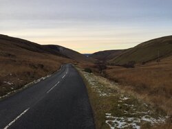
Past Lochranza, and started the climb up Glen Sannox.
View attachment 152057
That was the steepest climb of the day - 600ft over maybe a couple of miles.
View attachment 152059
Looking back down.
At that point, I heard an ominous noise from my pocket - the phone battery was flat, so the Strava tracking stopped, and no more photos. So I have no evidence of the speed I got to coming down the other side of that hill. But it’s the fastest I’ve ever done on a bike,
By this time, it’s starting to get dark, and the sunset was incredible - bright pink and orange - but no camera to record it. A ten mile cruise along the coast road back to Brodick, with just enough time for a quick beer before getting on the ferry at 4.30.
A great day, 62 miles in total, my longest trip so far!
But next time, I’ll probably choose a warmer day.


")