Your ride today....

Page may contain affiliate links. Please see terms for details.

Donger

Convoi Exceptionnel
Location
Quedgeley, Glos.
Well, that record didn't last long. Three days after the Col du Petit Ballon, I set a new PB of 783 metres of climbing, and a new personal altitude record of 1,183 metres .... both 20 metres more than the last one. Started out early from the gite on the lower slopes of the Petit Ballon in glorious weather. For once, the village of Luttenbach, down in the valley below wasn't shrouded in morning mist.
277 Luttenbach from above.JPG

When down in the village (alt 400m), I followed the little back road up the valley as far as Breitenbach:
279 Breitenbach.JPG

.... where I crossed the railway line and got back up onto the D road. By the time I got to the official start of the day's climb, the Platzerwasel, I recognised the little road emerging on the left as the bottom of the Petit Ballon descent from the other day. In stage 10 of the 2014 TdF, they had virtually no recovery time after that Cat 1 climb before immediately starting another Cat 1 climb up the Platzerwasel. I needed an easy day and then a day off before tackling the second one!
280 Start of Platzerwasel climb.JPG

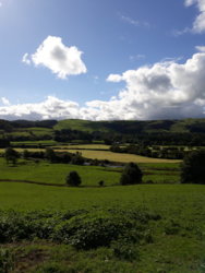
At the bottom of the climb, I had a nice encounter with a lady who was leading her two goats across the road to their pasture. They were so friendly and inquisitive that they proceeded to follow me along the road instead, and she had to scramble after them to get control. She wished me a "bonne route" and we went our separate ways. There followed much, much suffering, and lots of this:
281.JPG

... and this:
282.JPG
and then the plague of flies that @cosmicbike tempted fate by mentioning the other day. I hate the little bstds. When you are starting to wobble about at 4mph, you just can't swat them away for fear of losing control, and you just have to find a way of ignoring them. My thighs were really aching after my previous rides, too, so today's ride forced me to dredge up every bit of determination I could find. I am starting to realise that the key to this climbing lark is as much mental as it is physical. Anyway, made it to the top, setting new PBs and, (afterwards), feeling tremendous satisfaction. At the time, I just felt totally shagged .... as you might deduce for yourselves from this next shot:
284 Totally shagged.JPG

Those bloody flies were hanging about, swarming around the col sign, waiting for cyclists to turn up. They know, you know. I turned the bike around and got out of there as fast as I could. The descent was stunningly enjoyable. I'd had the chance to check out the road surface on the way up, so I could enjoy the big long straights and the sweeping hairpins for 15-20 minutes of silent, effortless speeding. Thank goodness I brought my disc brake bike, though. My other one would have frightened the crap out of me. A further gentle descent back to Luttenbach went easily too, but that still left the nasty little climb back up to the gite. I let myself down by stopping at the hairpin bend 100 yards from home for a breather (for the first time all week), just as the only other cyclists I'd seen on those lower slopes came by .... the first one giving me a cheery, effortless "bonjour!" to add insult to injury. At least the second guy had the good grace to look like he was suffering too:
287 Just below the gite.JPG

I may get the chance for one or possibly two more rides this holiday, and I'm studying the maps, looking to see which one(s) I might be able to do. Luttenbach is just such a perfect base for cycling, (half way between the Route du Vin and the Route des Cretes), that I'm spoiled for choice. I love Alsace. Why does it all have to end so soon? 20.2 miles today, half up, half down.
Cheers, Donger.
 
Last edited:

pjd57

Veteran
Location
Glasgow
Barbers, then Freewheel North run , mainly on the canal, followed by a trip to internet cafe to print travel stuff.

Probably about 20 miles , but Strava/ phone problems continue , more long straight lines.
 

colly

Re member eR
Location
Leeds
6.20 and out the door for a brief morning spin. I should have done it an hour before though. The traffic on the way back was K rap.

So I crossed the park and Cycled along Street Lane a right at the Moorton Corner lights over the ring road and north in the direction of Harrogate. Left around Eccup Reservoir and took King Lane down to Otley Road.
Up through Bramhope and after an interminable wait for a gap in the early morning traffic I crossed the main airport road and made for the back of Otley Chevin I turned right to take the long steep downhill East Chevin Road but once I got on the decent it dawned on me I would be coming back in towards Leeds up the main A660 with all the traffic. So about a third of the way down I turned into a car park had a drink and set off back up the hill. Retraced my steps and suffered the indignity of sitting in traffic at Harrogate Road, Moortown and Oakwood lights.:sad:

Still a good run out but the early traffic took the edge off it. 24 miles and 1400 ft of up. Fixed wheel.


View: https://ridewithgps.com/trips/27469818
 

cosmicbike

Perhaps This One.....
Moderator
Location
Egham
Not been out for a couple of days, work hours have been odd so no cycle commuting. After getting home in the early hours, then getting up early to walk my daughter to 'big' school I figured a trike ride was in order.
Aside from 1 gate, I can get most of the way from Staines to Hampton Court on the towpath, so that was the ride out sorted. Even with full suspension the ride was rough, and if anything on the trike wasn't loose at the start, it was at the end! Arrived at Hampton Court and a photo opportunity
6 Sept 2018 Trike at Hampton Court.jpg

I contemplated continuing to Kingston, but domestic duties called. Rather than towpath and rattles all the way home I opted for the roads:ohmy: I'm still a little nervous on the busier roads, so it does me good to go on them. No grief from any drivers which was nice, and I got a decent pace going through Molesey to Walton, turning off towards Weybridge and then back home through Laleham and Staines.
With 31.5 miles in the bag, that's the metric half done for September.
Trike needs new tyres, the blue protection layer is visible on the front left Marathon Plus. I think a pair of Big Apples are on the cards.
 

Rickshaw Phil

Overconfidentii Vulgaris
Moderator
Yesterday's ride:

It's challenge ride time again and I got myself up and about early to try something different. I was using the Raleigh and aimed to head down the Severn Valley to Bewdley. I have ridden over there before and the route I took that time was 89 miles so I knew I'd have to make some changes to get the century.

I thought it would be best to get the extra distance in early so started off with what has become a regular route to Condover, Atcham, Upton Magna and Walcot, then turned off this route through Garmston and Leighton where I joined the road to Ironbridge just where it ramps up quite steeply. It was a good introduction to what was to come through the rest of the day though and the descent the other side was quite enjoyable.

At Ironbridge the titular bridge is mostly covered up while major restoration work is ongoing. Part of it has been uncovered though, showing off the new paintwork which has been matched to the original colour (a change from the grey that we've been used to).

I could have crossed the bridge and joined NCN route 45 here but knowing that bit of path is often rough and muddy chose to stick to this side of the river as far as Coalport and cross the bridge there instead. Turning off the road by the old railway station I was now onto the old trackbed heading for Bridgnorth. This route is fantastic for how flat it is, with only authorized vehicles allowed, but unfortunately the surface lets it down as it's very rough and potholed meaning my speed for the next few miles was down around 10mph.

At Bridgnorth I had a bit of a tour round High Town then dropped down to Low Town and went to have a nose at the railway station where the first train of the day was being prepared. I hung around long enough to see the engine being coupled up and to take off my fleece and trouser legs as the chilly morning was warming up into a nice day, then pressed on along route 45.

From here on the rest of the day was going to be hilly. This part of Shropshire and Worcestershire is a land of gentle rolling hills seperated by steep sided valleys so for the most part there is no flat route from one place to another. I started off with the climb out of town through Oldbury Wells then the gentle descent to Eardington before turning off and tackling the steep series of climbs past Astbury Hall. I decided to give the off-road bit past Chelmarsh Reservoir a miss this time and stuck to the road through Chelmarsh village then down the lane to Hampton instead. I'd timed it fairly well and got to Hampton Loade station just after the train from Bridgnorth had arrived and before the one from Kidderminster had turned up. That gave me a few minutes to follow the path along the lineside to a good vantage point for getting photos of both trains. I chose to have my elevenses stop here then carried on along the rollercoaster of a path to the Severn Valley Country Park (got a "well done" from a couple of walkers for getting up the steepest climb without leaving the saddle:smile:) where I crossed the river and started the next lot of climbing on my way to Arley.

The descent into Arley is a good one with a wide, fairly straight road and a reasonable surface. Today though I couldn't make the most of it, having to brake to avoid running into a flock of pheasants milling about in the road. I crossed the river again here then climbed up to the station where I only had to wait a few minutes to see another train arrive (diesel hauled this time but I took a photo anyway) then I carried on with the climb up to Button Oak where I left route 45 for a bit and took the main road to Bewdley. There is a little more climbing on this road then a tremendous descent into town during which I hit my top speed of the day: 38.8mph. I'm sure it would be possible to go faster but you need to be wary of the road surface in places.

I arrived at the station in Bewdley and paused a while to have a coffee, eat my lunch and see the trains come in again, then it was time to tackle the trek home and all the hills that I knew would be involved. I was leaving town by climbing up to part called The Lakes (which doesn't appear to have any lakes) then dropping down a lane to the trackbed of the old Tenbury - Bewdley railway which gives some nearly flat riding for a couple of miles into the midst of the Wyre Forest. This has a better surface than the railway path I was on earlier, with some repair having been done fairly recently (although you do still have to beware of a few potholes).

Eventually you have to leave this bit and if following route 45 there is a bit of descent followed by what feels like a never ending climb back up to Button Oak. The forest roads are quite well surfaced at the moment and in some places are smoother than the tarmac ones.:rolleyes:

At Button Oak I was back onto tarmac and the climbing continued to Button Bridge before a shortlived respite. I was headed for Bagginswood next and again this road feels like an unrelenting climb. It's also in quite a bad state and I was often having to be right out in the middle of the road to avoid the potholes. Councillor Davenport, who recently went on record saying that Shropshire doesn't have a pothole problem, needs to come and drive some of the roads round here - or better still cycle them and see what we have to put up with.

At Stottesdon I was paused for a photo when an artic went past. I was just thinking it a bit big for these roads when I got hit by the smell xx(xx(xx( - it was obviously carrying animal carcasses and I really could have done without that! I decided to wait in the village a few minutes to let it dissipate before following along the same road.

The long bouts of climbing interspersed with short sharp descents continued through Cleobury North, Ditton Priors (stopped for another snack here) and Upper Netchwood where there was a really steep descent. I was trying a new (to me) route over Wenlock Edge through Brockton and Easthope and this turns out to be probably the easiest way over the Edge that I've tried (in this direction at least). One to remember for other occasions.

Around here I started to get concerned about the distance. It was looking like I'd be short of the required 100 miles still. I took longer route to Cardington which helped a bit but I'd still be a couple of miles short at the end so despite tired legs I had to carry on past my usual turning at Cantlop and approach Condover from the north east, then take the longer way via Lyth Hill to finish off. It did the job and I got the imperial century with a little bit to spare.

101.3 miles at 12.4 mph average for this trip. Time including the stops was even slower at 11 hours.

DSC0006990.jpg

A bit of early morning mist at Atcham.

DSC0006993.jpg

The Iron Bridge still mostly under wraps but the new colour (matched to the original when it was built) is on display. I like it but there have already been huffy letters to the local paper about it.

DSC0006999.jpg

Following the former Severn Valley Railway trackbed between Coalport and Bridgnorth.

DSC0007003.jpg

Up by the remains of Bridgnorth Castle.

DSC0007020.jpg

Lineside viewpoint at Hampton Loade. The engine (Churchward 28XX class) is 100 years old this year.

DSC0007026.jpg

Crossing the river at Arley. It's a footbridge only, which causes confusion in the summer when tourists come down here expecting to be able to drive across.

DSC0007044.jpg


Bewdley.

DSC0007047.jpg

In the Wyre Forest and about to start the long climb to Button Oak.

DSC0007052.jpg

At Ditton Priors.

DSC0007055.jpg

Crossing Wenlock Edge and looking to the next line of hills I have to cross.
 

C R

Guru
Location
Worcester
Quick ride at lunchtime to get some miles in after a week of no cycling. Nothing much to report.

A delivery driver walked out onto the road from behind the van without looking, lucky for both of us I was giving the van a wide berth to avoid dooring. He didn't seem too pleased of being startled. I carried on, and he came up behind reving the engine hard. He gave plenty of space when overtaking, which meant he drove through a blind bend straddling the solid white line:wacko:.

Feeling good after the holiday rest, l gave it some welly. Past Pirton church i felt like it might start raining, so gave it some more up hill before Stonehall Common, pb there today.

11 miles at 15.3mph and feeling great.
 
Last edited:

C R

Guru
Location
Worcester
I suspect Nafford may well be open to the public, but whoever owns the patch doesn't want to encourage access.

As regards the Coventrys and their houses, it is easy to get confused because there are two large houses known as Croome - or sometimes Coombe - Court.

The Earl of Coventry lived in the one in Earls Croome, entrance opposite the church, main entrance and long driveway off the A38.

The other Croome Court was two or three miles away on the other side of the M5 in the middle of an area marked on the map as Croome Park.

That house is better known than the other one, and it also belonged to the Earl at some point.

Road access is only possible from the north, through the village of High Green.

When I was living nearby that Croome Court was bought by a religious sect, possibly Hare Krishna, which caused some consternation in conservative - and Conservative - rural South Worcestershire.

I believe the sect proved harmless enough, and they since sold it.

According to wiki, the house has had several uses and owners, and it appears it is being restored as a heritage attraction.

Worth a look next time you are over that way.

The hair pin bend on the nearest minor road provides a view of the house, even if you aren't allowed down the drive.

https://en.wikipedia.org/wiki/Croome_Court
We visit Croome Court fairly often. The children like exploring the grounds, and the house is now open to visit, and from what it looks they are slowly restoring the interior after fixing the roof. It is a National Trust property now, and well worth a visit. There is also a small exhibition dedicated to the use of the Defford air field during the second world war.
 

welsh dragon

Thanks but no thanks. I think I'll pass.
Very dark and rainng first thing, but it cleared up a bit so I took a chance. 12 mile bimble today in windy and sometimes cold conditions. I wish I had taken my gloves with me. Doh. When the sun came out it was lovely.

The weekend is going to be horrible here, so another reason to get out today.

20180907_110252.jpg
20180907_105901.jpg
20180907_113744.jpg
20180907_110250.jpg
 

Attachments

  • 20180907_110252.jpg
    20180907_110252.jpg
    103.7 KB · Views: 22

Aravis

Putrid Donut
Location
Gloucester
This is a delayed write-up for yesterday's ride, but it was a good one so I think it's still worth doing. My father-in-law is at home (Horton, near Northampton) recovering from a short visit to hospital and was looking forward to a visit; my wife was quite happy to drive one way; I needed a ride for the ICAM challenge.

Gloucester to Northampton by a direct route isn't long enough. The weather forecast suggested that a dog-leg to the north was the best strategy, leading me to this route:

Sep06m.JPG

Sep06e.JPG


Part of the deal was to be there early afternoon, so I set of just before 5am. The A38 north is quite comfortable in the dark, the A46 beyond Tewkesbury less so but much of it can be by-passed. I went straight through Evesham and took what used to be the A46 onwards to Alcester. I reckoned that the obvious route via Henley-in-Arden and Dorridge would be pretty busy at that time, so I plotted a largely minor road route to east, which worked well. Crossing the river Blythe near Hampton in Arden reminded me that I'd crossed the backbone of the country. It didn't seem too arduous!

The next target was Packington Hall, near Meriden. Some weeks ago I put out a question on the forum, asking whether it is possible to cycle through the estate as RwGPS suggests you can. I didn't see any replies so I presume no-one knew. When I arrived at Warwick University in 1978 I was fortunate to pass a audition for the University Chamber Choir, which over the three years gave me several trips to venues near and far and some memorable events. The very last was at Packington Hall in 1981, an invitational arm-twisting event for the local bigwigs, and judging from the size of the houses in the surrounding area there's no shortage of them.

What appeared to be the main entrance is awkwardly placed on the A45, but I only needed to ride on it for a few hundred yards so it was bearable. There was nothing to suggest that you can't go in, just a warning to expect to be watched. I was quickly into a dreamworld of trees, grassland, lakes and herds of resting deer. But at the eastern entrance there was a lowered barrier operated by electronic key and no obvious means of requesting access. No problem, me and my bike could duck underneath. There's one other entrance, to the north west, and if that's the same it looks as though you're expected to go in and out via the main entrace. It's perfectly possible to ride through if you're brazen enough, and well worth doing so, but perhaps not with a big group. However, my personal pilgrimage is complete.

A mile or two later I was in the middle of Meriden, the traditional centre of England. I knew nothing of this memorial before watching the Tour of Britain stage the previous day:

CM1.JPG

CM2.JPG


Apart from the position of some roads, Warwick University has changed out of all recognition. I know I'm biased, but I remember it being far more photogenic. I did notice an army of people in protective gear hard at work on the student accomodation, not doubt making it ready to be trashed again by the new influx in a few days' time. And exactly 40 years ago that was me. It makes one a little misty-eyed.

Soon afterwards, just after crossing the dual-carriageway A46, there was a police roadblock which fortunately I managed to blag my way through - it would have been problematic if I'd been forced to divert. It was the aftermath of a collision and fire at a crossroads - pretty spectacular, but stopping for a photo wasn't part of the deal!

I was then into a world I didn't know at all, the rural and quite remote landscape to the east of Leamington Spa. This is where the Cotwolds gradually lose their identity at their northern extent, so there are climbs, steep ones if you want to look for them. I tend to avoid Ordnance Survey "arrows" if I can. For me it's the point at which confidence turns to hope.

Even on the narrowest roads the surfaces were generally excellent, showing that it can be done. I thought it was perfect cycling country, very little traffic, lots of good roads to choose from and something for everyone - with some of the bigger Cotswold climbs nearby for those that way inclined.

Then, all too suddenly, I reached the village of Blisworth and roads that I know well. Coming from that angle it was convenient to loop round through Salcey Forest, a nice finish to any ride. So that was 117.40 miles, a settee to sleep on for a couple of hours and an excellent meal. :smile:
 
Last edited:
This is a delayed write-up for yesterday's ride, but it was a good one so I think it's still worth doing. My father-in-law is at home (Horton, near Northampton) recovering from a short visit to hospital and was looking forward to a visit; my wife was quite happy to drive one way; I needed a ride for the ICAM challenge.

Gloucester to Northampton by a direct route isn't long enough. The weather forecast suggested that a dog-leg to the north was the best strategy, leading me to this route:

View attachment 428896
View attachment 428897

Part of the deal was to be there early afternoon, so I set of just before 5am. The A38 north is quite comfortable in the dark, the A46 beyond Tewkesbury less so but much of it can be by-passed. I went straight through Evesham and took what used to be the A46 onwards to Alcester. I reckoned that the obvious route via Henley-in-Arden and Dorridge would be pretty busy at that time, so I plotted a largely minor road route to east, which worked well. Crossing the river Blythe near Hampton in Arden reminded me that I'd crossed the backbone of the country. It didn't seem too arduous!

The next target was Packington Hall, near Meriden. Some weeks ago I put out a question on the forum, asking whether it is possible to cycle through the estate as RwGPS suggests you can. I didn't see any replies so I presume no-one knew. When I arrived at Warwick University in 1978 I was fortunate to pass a audition for the University Chamber Choir, which over the three years gave me several trips to venues near and far and some memorable events. The very last was at Packington Hall in 1981, an invitational arm-twisting event for the local bigwigs, and judging from the size of the houses in the surrounding area there's no shortage of them.

What appeared to be the main entrance is awkwardly placed on the A45, but I only needed to ride on it for a few hundred yards so it was bearable. There was nothing to suggest that you can't go in, just a warning to expect to be watched. I was quickly into a dreamworld of trees, grassland, lakes and herds of resting deer. But at the eastern entrance there was a lowered barrier operated by electronic key and no obvious means of requesting access. No problem, me and my bike could duck underneath. There's one other entrance, to the north west, and if that's the same it looks as though you're expected to go in and out via the main entrace. It's perfectly possible to ride through if you're brazen enough, and well worth doing so, but perhaps not with a big group. However, my personal pilgrimage is complete.

A mile or two later I was in the middle of Meriden, the traditional centre of England. I knew nothing of this memorial before watching the Tour of Britain stage the previous day:

View attachment 428899
View attachment 428900

Apart from the position of some roads, Warwick University has changed out of all recognition. I know I'm biased, but I remember it being far more photogenic. I did notice an army of people in protective gear hard at work on the student accomodation, not doubt making it ready to be trashed again by the new influx in a few days' time. And exactly 40 years ago that was me. It makes one a little misty-eyed.

Soon afterwards, just after crossing the dual-carriageway A46, there was a police roadblock which fortunately I managed to blag my way through - it would have been problematic if I'd been forced to divert. It was the aftermath of a collision and fire at a crossroads - pretty spectacular, but stopping for a photo wasn't part of the deal!

I was then into a world I didn't know at all, the rural and quite remote landscape to the east of Leamington Spa. This is where the Cotwolds gradually lose their identity at their northern extent, so there are climbs, steep ones if you want to look for them. I tend to avoid Ordnance Survey "arrows" if I can. For me it's the point at which confidence turns to hope.

Even on the narrowest roads the surfaces were generally excellent, showing that it can be done. I thought it was perfect cycling country, very little traffic, lots of good roads to choose from and something for everyone - with some of the bigger Cotswold climbs nearby for those that way inclined.

Then, all too suddenly, I reached the village of Blisworth and roads that I know well. Coming from that angle it was convenient to loop round through Salcey Forest, a nice finish to any ride. So that was 117.40 miles, a settee to sleep on for a couple of hours and an excellent meal. :smile:

Excellent write up and well done on the big miles! :notworthy:
 

Donger

Convoi Exceptionnel
Location
Quedgeley, Glos.
My last ride in Alsace, this morning, and a quite unique one. I've managed a couple of monster climbs this week, but didn't have another one in me, so I decided to cheat a little bit. I got the car out and drove up to my highest point, the Col du Platzerwasel (1,183m), and started my early morning ride from there. I was going to wear my club kit today, but didn't want anyone catching me cutting corners, so I didn't. Anyway, today's ride was a shortish one along the "Route des Cretes" - a beautiful road that runs right along the ridge line of the Vosges mountain chain. We drove it the other day, an there were stunning views to be had into Lorraine to the West, and right across the Rhine Plain and into the mountains of the Black Forest to the East. Except there weren't this morning. The clouds were so low that visibility was down to about 100m in places, and I was lucky to snatch a shot of any view at all from the Platzerwasel:
289 Above the clouds.JPG

From there, the road dropped down a bit before starting a 12% climb up to a new high point for me, at the top of the Breitfirst (1,280m):
290 Le Breitfirst.JPG

Then down a bit again, before a gentler climb up to the Markstein (1,183m, just like the Platzerwasel):
292.JPG

(Not much of a view to be had there, either, despite the panoramic cafe). I put the hammer down and sped (by my standards) along the ridge to my main target, the Grand Ballon (1,325m). The last mile was uphill - I would say about 10% - but I was feeling good and made it to the top OK.
296 Le Grand Ballon.JPG

By now, the fog was lifting, and the other mountains were coming into view, but the sign about a view of the Alps was optimistic (even though Switzerland is only 30-40 miles away):
298.JPG

I turned the bike around and particularly enjoyed the next mile, as it started with a hairpin and was downhill all the way:
299.JPG

I had to climb back over the Markstein and then the Breitfirst again on the way back, bringing up something like 350m of climbing, despite my cheat. On the way back, it was like someone had called another Cannonball Rally in honour of the late Burt Reynolds, as there were sports cars from Britain, Italy, Switzerland, Germany .... all over, revving like mad and speeding along the ridge in the opposite direction. I had to put my lights back on as it was still a little foggy as I approached the Col du Platzerwasel and views were limited again:
300 Through the clouds.JPG

Made it back to the car on 18.3 miles, with (I would guess) about 350m of climbing. Considerably easier doing it in bits and pieces that all in one big climb. A shame about the clouds, though. Still a totally unique experience for me, though, getting to ride along the crest, taking in some of the very biggest peaks the Vosges have to offer. I have loved the whole week in Alsace. Just a tad under 80 miles in 4 rides, but lots of climbing and some fantastic scenery on the Route des Cretes, the Route du Vin and the mountain climbs I did. And all without a satnav to be seen ..... done by trusty "Flatnav":
303 A week's rides in the Munster Valley.JPG

That's pretty much the whole Munster Valley (West of Colmar) covered, from the vineyards of Niedermorschwihr and Turckheim in the NE to the Platzerwasel and the Grand Ballon in the SW of the map (the dark line on the map). Loved every inch of it. Well, that's all of my explorer stuff done for another year. Where to go next year? (Thinks).
Cheers, Donger.
 
Last edited:

cosmicbike

Perhaps This One.....
Moderator
Location
Egham
My last ride in Alsace, this morning, and a quite unique one. I've managed a couple of monster climbs this week, but didn't have another one in me, so I decided to cheat a little bit. I got the car out and drove up to my highest point, the Col du Platzerwasel (1,183m), and started my early morning ride from there. I was going to wear my club kit today, but didn't want anyone catching me cutting corners, so I didn't. Anyway, today's ride was a shortish one along the "Route des Cretes" - a beautiful road that runs right along the ridge line of the Vosges mountain chain. We drove it the other day, an there were stunning views to be had into Lorraine to the West, and right across the Rhine Plain and into the mountains of the Black Forest to the East. Except there weren't this morning. The clouds were so low that visibility was down to about 100m in places, and I was lucky to snatch a shot of any view at all from the Platzerwasel:
View attachment 428962
From there, the road dropped down a bit before starting a 12% climb up to a new high point for me, at the top of the Breitfirst (1,280m):
View attachment 428963
Then down a bit again, before a gentler climb up to the Markstein (1,183m, just like the Platzerwasel):
View attachment 428964
(Not much of a view to be had there, either, despite the panoramic cafe). I put the hammer down and sped (by my standards) along the ridge to my main target, the Grand Ballon (1,325m). The last mile was uphill - I would say about 10% - but I was feeling good and made it to the top OK.
View attachment 428965
By now, the fog was lifting, and the other mountains were coming into view, but the sign about a view of the Alps was optimistic (even though Switzerland is only 30-40 miles away):
View attachment 428967
I turned the bike around and particularly enjoyed the next mile, as it started with a hairpin and was downhill all the way:
View attachment 428969
I had to climb back over the Markstein and then the Breitfirst again on the way back, bringing up something like 350m of climbing, despite my cheat. On the way back, it was like someone had called another Cannonball Rally in honour of the late Burt Reynolds, as there were sports cars from Britain, Italy, Switzerland, Germany .... all over, revving like mad and speeding along the ridge in the opposite direction. I had to put my lights back on as it was still a little foggy as I approached the Col du Platzerwasel and views were limited again:
View attachment 428970
Made it back to the car on 18.3 miles, with (I would guess) about 350m of climbing. Considerably easier doing it in bits and pieces that all in one big climb. A shame about the clouds, though. Still a totally unique experience for me, though, getting to ride along the crest, taking in some of the very biggest peaks the Vosges have to offer. I have loved the whole week in Alsace. Just a tad under 80 miles in 4 rides, but lots of climbing and some fantastic scenery on the Route des Cretes, the Route du Vin and the mountain climbs I did. And all without a satnav to be seen ..... done by trusty "Flatnav":
View attachment 428971
That's pretty much the whole Munster Valley (West of Colmar) covered, from the vineyards of Niedermorschwihr and Turckheim in the NE to the Platzerwasel and the Grand Ballon in the SW of the map (the dark line on the map). Loved every inch of it. Well, that's all of my explorer stuff done for another year. Where to go next year? (Thinks).
Cheers, Donger.

Next year, who knows, but do please continue with the excellent write ups, always a pleasure to read and view your piccies:okay:
 
A few write ups as a catch up . Not been out as often as life has gotten in the way. Week past Monday i got out for a 5 miler on the mtb . This week on the Tuesday i went on a route that took me around the outskirts of the town along the various trails and cycle paths. Wednesday saw the visit of my mother in law coincide with my visit to the shed to fetch my bike. Out to the rough moss and marvelled at the view towards Stannochy Bridge now they have finished tree felling. Home , lunch and in law still there i headed out again to escape but more of a poottle pace as my legs felt a bit dead. Today down to Arbroath and did a bit of the coastal path to Easthaven the sea on one side and the main Aberdeen to Dundee rail track on the other made for an interesting ride. A drink stop before the ride back . Easily my favourite route of the week. Ride safe and often people.
 

Donger

Convoi Exceptionnel
Location
Quedgeley, Glos.
Loving your write-ups, @Donger :thumbsup:

Sounds like you've had an absolute blast out there. :cheers:
Thanks. Yes, it has been amazing. I love this thread, and have derived so much inspiration from it in the past. Went to North Wales and did the Mawddach Trail earlier this year because of a couple of write-ups I'd seen on this thread. When I find somewhere good, I like to post pictures and descriptions that might inspire someone to follow in my tyre tracks. I shall be on the lookout for some more inspiration myself, now, as it's back to the humdrum life again next week. Keep posting, everyone.
 
Top Bottom