Game: Name that road!

Page may contain affiliate links. Please see terms for details.

robjh

Legendary Member
You are at the Bwlch Oerddws car park, on the A470 between Dinas Mawddwy and Dolgellau, looking North-West. So it's morning!

The Wales clue was pretty helpful. It looks like a pass and the road looks like an A road, leaving only a handful of possibilities. It's a road I've not ridden. Although I've cycled a lot in Wales, I don't think I've been north of the Severn on a bike, or if I have, only just.

I have one more suitable piture if you're all interested. After that I think I'm probably out.
Well done, spot on!
I had ridden up from the Dinas Mawddwy (eastern) side the previous evening and camped behind a wall just out of sight of the picture, and carried on towards Dolgellau (west, behind me in the photo) after the picture was taken.
 

Aravis

Putrid Donut
Location
Gloucester
This one is on the mainland of Great Britain - no offshore foray this time. Also, one clue I will give is that my elevation is over 500 metres, having ridden up the road you can see disappearing down the valley.

BP22a.JPG
 

robjh

Legendary Member
This one is on the mainland of Great Britain - no offshore foray this time. Also, one clue I will give is that my elevation is over 500 metres, having ridden up the road you can see disappearing down the valley.

View attachment 389823

Are we in the Peak District?
I was thinking maybe South Wales, or Scottish borders? Thought I had it at one point but the curve of the road up that long valley is wrong. It looks like a B- if not an A-road.
 

robjh

Legendary Member
This one is on the mainland of Great Britain - no offshore foray this time. Also, one clue I will give is that my elevation is over 500 metres, having ridden up the road you can see disappearing down the valley.

View attachment 389823
You are on the A4107 climbing from Cymmer to the Bwlch, and probably about here (where the cyclist is in streetview). The village in the distance is probably Abergwynfi.
upload_2018-1-3_21-22-38.png
 

Aravis

Putrid Donut
Location
Gloucester
Yes @robjh, that is the road. I'm actually a little bit higher - if you go back to streetview, you'll find that on the cyclist's right there's another switchback and soon after that a car park which could be where I'd stopped.

As many will know, there are three routes to this summit, and a while ago I planned out this route which includes all three ascents (the "55" marks where my photograph was taken):

Bwlch.jpg


Apparently, some of the inter-valley roads in South Wales, including this one and also the Rhigos, north of Treherbert on the map above, were built by miners who would otherwise have been unemployed during the depression in the 1930s. Ironically, it's the roads that have become their permanent legacy. The are wonderful roads.

I hope you have another good one.

Edit: actually I a little further along from the car park. You can find the exact spot by lining up the track which the car is about to pass.
 
Last edited:

robjh

Legendary Member
Yes @robjh, that is the road. I'm actually a little bit higher - if you go back to streetview, you'll find that on the cyclist's right there's another switchback and soon after that a car park which could be where I'd stopped.

As many will know, there are three routes to this summit, and a while ago I planned out this route which includes all three ascents (the "55" marks where my photograph was taken):

View attachment 389906

Apparently, some of the inter-valley roads in South Wales, including this one and also the Rhigos, north of Treherbert on the map above, were built by miners who would otherwise have been unemployed during the depression in the 1930s. Ironically, it's the roads that have become their permanent legacy. The are wonderful roads.

I hope you have another good one.

Edit: actually I a little further along from the car park. You can find the exact spot by lining up the track which the car is about to pass.
I covered a lot of that route, from Ogmore over Bwlch and Rhigos and down to Neath, with a CC group ride a few years ago, although I didn't immediately recognise that view - possibly because we were slogging up there in semi-darkness and dropping temperatures at the end of the day so I didn't appreciate it fully! Great day though, and I went back over the Rhigos again last year on my own.

I'll go and look for another picture, but if anyone else wants to step in and post one in the meantime, please go ahead!
 

Skuhravy

Veteran
Location
Darlo
Hey wait, I knew the Ullapool one - I thought about using that track and the ferry across Loch Broom when I toured up there a few years ago, until I realised the ferry had been cancelled and my map was 20 years out of date (that's what happens when you buy your OS maps second hand from the library).

Here's one to keep it rolling:
 

Attachments

  • P1010055.JPG
    P1010055.JPG
    258.3 KB · Views: 64

iandg

Legendary Member
Of course, @Siclo, I'd be delighted.

As for the previous one, I was convinced that the shiny road to the right of the hill was too steep to be the Ingleton road, but I hadn't taken into account how high the Fleet Moss road is, so the perspective tricked me. Something like that anyway!

Now for something completely different, but pretty recognisable. Not my usual choice of road - on this tour I was not the route-planner...

View attachment 388081

I would have got that one - but ony just seen this thread ^_^
 

Skuhravy

Veteran
Location
Darlo
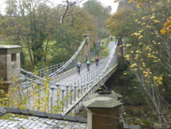
It also comes with a wooden decking.

And it's the best bridge. But that probably won't help you find it.

Someone must recognise it - anyone who rode LEL will have ridden over it twice.
 
Top Bottom