Strava and the Clyde Tunnnel

Page may contain affiliate links. Please see terms for details.

Dwn

Senior Member
This is a question which probably needs some very specific local knowledge for it to be answered.

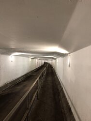
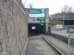
The Clyde Tunnel connects the districts of Whiteinch and Govan, a few miles west of Glasgow city centre. Underneath the car tunnel there are also a couple of bike and pedestrian tunnels, which are not particularly heavily used - they are a bit gloomy and still suffer from a bad reputation dating to the 80’s and 90’s (cctv now, so pretty safe).

My Garmin edge appears to count the time I take to go through it, but not the distance. Recording on Strava via my iPhone does the opposite - counts the distance, but not the time. Neither of them appear to count feet climbed. Of course, I may have this completely wrong (I find the tunnel mildly disorienting) so wondered if any local Strava experts knew how it works.
 

Attachments

  • 4C31AB99-5999-4990-8BAA-39E0CA30D20E.jpeg
    4C31AB99-5999-4990-8BAA-39E0CA30D20E.jpeg
    51.2 KB · Views: 18
  • 40BCF874-3801-4C34-BBDE-A6D43309880B.jpeg
    40BCF874-3801-4C34-BBDE-A6D43309880B.jpeg
    52.8 KB · Views: 17

Milkfloat

An Peanut
Location
Midlands
You won't get GPS down there, unless you have a speed sensor on the wheel then the Edge won't give distance. I don't know how Strava does it on a phone, it may just join up the last known points as a straight line or it may use basic triangulation from the mobile phone towers and WiFi. What do the traces look like on the Strava Map?
 

Twilkes

Guru
Wikipedia thinks that 'the [road] tunnels are each 762 metres (2,500 feet) long with a gradient approaching 6%' so I would imagine the pedestrian tunnels are about the same length but with a slightly higher gradient at either end because they have to go under the road tunnels.

But yes, no GPS down there. There used to be some 'interesting' graffiti that I saw the first time I walked through it back in 2007ish, and I went back a month later with a camera to take some photos of it but it had all been whitewashed off!
 
OP
OP
Dwn

Dwn

Senior Member
You won't get GPS down there, unless you have a speed sensor on the wheel then the Edge won't give distance. I don't know how Strava does it on a phone, it may just join up the last known points as a straight line or it may use basic triangulation from the mobile phone towers and WiFi. What do the traces look like on the Strava Map?
The Strava map appears to just draw a straight line slightly to the west of the actual tunnel. Presumably the database has no details for the tunnel itself
 

Milkfloat

An Peanut
Location
Midlands
I don't think Strava map match (i.e. snap the trace to a road/trail), it is display as a separate layer only. The straight line will be an estimate based on your last known positions.
 

Twilkes

Guru
As far as I remember, Strava elevation data is created by riders riding with barometric devices, they don't have a master lookup table of the elevation for all the maps they reference. So as there's no GPS down there they won't have any elevation data for it (nor can I find any information on the web except for that vague Wiki reference). And as some barometric devices are slightly/wildly off, the elevation data they do have occasionally doesn't make sense, or e.g. is different on a segment compared to when you use the route planning tool.

They presumably have a map showing the path of the road, but as there is no GPS signal they can't place you on it. I think my GPS just draws a straight line between the last successful GPS ping before the tunnel and the first one after the tunnel.

Another thing with the maps is that although sometimes it looks as if my ride path doesn't line up with the road on the map, if I switch to satellite view it's generally on the road, i.e. the map might show a road as 2mm wide on my monitor, but if I switch to satellite view the photo of the road itself is actually 5mm wide and everything lines up.
 
  • Like
Reactions: Dwn
OP
OP
Dwn

Dwn

Senior Member
Wikipedia thinks that 'the [road] tunnels are each 762 metres (2,500 feet) long with a gradient approaching 6%' so I would imagine the pedestrian tunnels are about the same length but with a slightly higher gradient at either end because they have to go under the road tunnels.

But yes, no GPS down there. There used to be some 'interesting' graffiti that I saw the first time I walked through it back in 2007ish, and I went back a month later with a camera to take some photos of it but it had all been whitewashed off!

That video made me laugh! I used the tunnel a few times in the 80’s and 90’s and it was not a pleasant experience. Graffiti everywhere, broken glass, and on a couple of instances groups of the local bams hanging about.

Yeah, I’d guess a slightly higher gradient; it’s certainly enough to get the pulse rate up.
 

Ming the Merciless

There is no mercy
Location
Inside my skull
 
  • Like
Reactions: Dwn

pjd57

Veteran
Location
Glasgow
No idea about the answer to the question.
But the tunnel is definitely much better now than it was years ago.
Still not a huge fan though.
 
  • Like
Reactions: Dwn
OP
OP
Dwn

Dwn

Senior Member
I’m going to email Glasgow city council (the tunnel operator) and ask if they have the length and elevation data. Not hopeful, but will post response here.
 

Twilkes

Guru
Went through it again today, GPS disappeared for almost exactly 1000m, so if it's 500m down and 500m up, and if the gradient might average out at 6%ish, which it might do compared to a few other 500m climbs I've got times for, it would be around 30m of descent and climbing, or 100ft.
 
  • Like
Reactions: Dwn
OP
OP
Dwn

Dwn

Senior Member
I find it hard to be sure, but it feels like there is a fair amount of bend in the roadway, particularly at the start and end. I’ve emailed gdc but not very confident of getting a response.
 
Top Bottom