
You are using an out of date browser. It may not display this or other websites correctly.
You should upgrade or use an alternative browser.
You should upgrade or use an alternative browser.
Your ride today....
- Thread starter gbb
- Start date
Page may contain affiliate links. Please see terms for details.
ColinJ
Puzzle game procrastinator!
- Location
- Todmorden - Yorks/Lancs border
Ah - I spotted it on the map years ago but have never gone that way, especially because I don't usually have lights on the bike!
Yes, it's only very short but would be a bit dodgy with no front light, especially on an overcast day. But with two riding through it would be sufficient if only one person had a front light. Perhaps we can add my route today to our list. You would only need to 'find' another 7 miles to get the metric century so riding just 3.5 of my 6 miles back to Littleborough and then back to Tod would get the 100km.Ah - I spotted it on the map years ago but have never gone that way, especially because I don't usually have lights on the bike!
East to Knaresborough today on the road bike top and tailed on the A59 with Bilton Lane and the wider section of NCN636 in-between

Queuing traffic up the hill at Knaresborough from High Bridge over the River Nidd is a thing of the past as the double set of traffic lights at a staggered cross roads has been replaced by two mini roundabouts

North to Farnham where the easterly climb out of the village is eased by joining it part of the way up

Continued east through Ferrensby, Arkendale, to Marton where the village pub seems to be partially shaped as per its name

On through Grafton and onto Lower Dunsforth passing through some very low land.

Then followed the route of NCN688 Way of the Roses south east through Upper Dunsforth, which has a sign giving a nice warm welcome to cyclists – Be quite!, and Great Ouseburn. Leaving the NCN the fringe of Little Ouseburn followed and then at Thorpe Underwood I headed east to the banks of the River Ouse, unfortunately too much in the way of buildings in-between to get a photo. Retraced my route back west and onto Whixley and then south across a very fast busy section of the A59 to Cattal crossing the Knaresborough-York railway line still with locally operated crossing gates.

The TLs on the bridge over the Nidd typically went red as I got to them. Westward into a fading sun through Cowthorpe. Once across the A1(M) bridge and the older, steeper, A1 now A168 bridge progress came to halt as my front light fell off. One of those Halfords gro pro mount under a Garmin extension ones, which I had assembled to a row of Go Pro mounts to flip it the correct way up – one of those mounts had broke so the light was refitted as intended. Turned north to Little Ribston and then south west to Spofforth and west up Haggs Road to the A658

Yesterdays route along Rudding Lane was followed and the TLs on the bridge went green as I approaching them so for once I got I decent run at the following bank and a PR. Stayed on the A661 to the first main junction then my normal route to the east side of Harrogate town centre but varied due to a road closure and use made of a shared footway/cycleway along the south side of the Stray.

Back on the A59 I managed to strike a rougher than normal section of its rough road surface and that proved to the final straw for my Go Pro camera mount and the Go Pro went spinning off the bike into the road – thankfully the A59 was momentarily quite and I retrieved the camera intact. Remounted the bike to find the rear wheel had a puncture – things do happen in threes.
With just 1.1 miles to go did not see the point of trying to fix it so the final 130ft of climbing was by Shanks’ Pony wheeling the bike. Wheel seems fine but have a spare (albeit with a 10 speed cassette not 11) if something nasty has happened to it.
42.8 miles cycled and 1892ft cycled up at an average of 13.2mph

Queuing traffic up the hill at Knaresborough from High Bridge over the River Nidd is a thing of the past as the double set of traffic lights at a staggered cross roads has been replaced by two mini roundabouts
North to Farnham where the easterly climb out of the village is eased by joining it part of the way up
Continued east through Ferrensby, Arkendale, to Marton where the village pub seems to be partially shaped as per its name
On through Grafton and onto Lower Dunsforth passing through some very low land.
Then followed the route of NCN688 Way of the Roses south east through Upper Dunsforth, which has a sign giving a nice warm welcome to cyclists – Be quite!, and Great Ouseburn. Leaving the NCN the fringe of Little Ouseburn followed and then at Thorpe Underwood I headed east to the banks of the River Ouse, unfortunately too much in the way of buildings in-between to get a photo. Retraced my route back west and onto Whixley and then south across a very fast busy section of the A59 to Cattal crossing the Knaresborough-York railway line still with locally operated crossing gates.
The TLs on the bridge over the Nidd typically went red as I got to them. Westward into a fading sun through Cowthorpe. Once across the A1(M) bridge and the older, steeper, A1 now A168 bridge progress came to halt as my front light fell off. One of those Halfords gro pro mount under a Garmin extension ones, which I had assembled to a row of Go Pro mounts to flip it the correct way up – one of those mounts had broke so the light was refitted as intended. Turned north to Little Ribston and then south west to Spofforth and west up Haggs Road to the A658
Yesterdays route along Rudding Lane was followed and the TLs on the bridge went green as I approaching them so for once I got I decent run at the following bank and a PR. Stayed on the A661 to the first main junction then my normal route to the east side of Harrogate town centre but varied due to a road closure and use made of a shared footway/cycleway along the south side of the Stray.
Back on the A59 I managed to strike a rougher than normal section of its rough road surface and that proved to the final straw for my Go Pro camera mount and the Go Pro went spinning off the bike into the road – thankfully the A59 was momentarily quite and I retrieved the camera intact. Remounted the bike to find the rear wheel had a puncture – things do happen in threes.
With just 1.1 miles to go did not see the point of trying to fix it so the final 130ft of climbing was by Shanks’ Pony wheeling the bike. Wheel seems fine but have a spare (albeit with a 10 speed cassette not 11) if something nasty has happened to it.
42.8 miles cycled and 1892ft cycled up at an average of 13.2mph
Last edited:
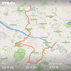
My usual trip across Glasgow to the football was adapted to include a couple of chores for my Mrs. So it was across the Clyde to Bellahouston, passing Ibrox, then onto Clarkston before heading to Celtic Park.
I past Hampden and Shawfield on the way.
I would have passed Firhill on my home as well, but a puncture and a broken pump meant I didn't cycle home from the football.
Still a great few hours out.
I past Hampden and Shawfield on the way.
I would have passed Firhill on my home as well, but a puncture and a broken pump meant I didn't cycle home from the football.
Still a great few hours out.
Attachments
Jenkins
Legendary Member
- Location
- Felixstowe
Another bright & sunny day in Suffolk so I took the opportunity to finally get the 100k in for the month. A straight run up from home to Woodbridge through Kirton & Brightwell, then through Rendlesham forrest to Butley and Tunstall, up to Snape and then across to Aldeburgh. Absolutely packed on the seafront there, but bitterly cold thanks to the sea breeze, so I decided not to stop and headed up to Thorpeness and then back home via Rendlesham instead of Butley, followed by a bit of a diversion around Bucklesham & Falkenham just to make sure I had enough mileage.
https://www.strava.com/activities/2172549106

.png")
And you know that it's been perfect weather for cyclists when your Stava flybys look like this...

https://www.strava.com/activities/2172549106
And you know that it's been perfect weather for cyclists when your Stava flybys look like this...
Nice route. When you say Strensham to Eckington, is there a way across the Avon at Strensham without going all the way to Twekesbury?Margaret PR and Jules H on this one. We took the standard route to Strensham and Eckington in the mist. Combertons took us to Cropthorne and Fladbury where the mist finally vanished. Nice cafe but expensive. Return by Throckmorton and Wadborough in glorious sunshine. Keith W rode up to us on Kinnersley bank so a chat ensued. Usual run back with my energy levels dropping. 53 smiles
Mr Celine
Discordian
- Location
- Waxing my moustache
Same weather as Friday, 13c and no wind. I've still not finished the winter strip down and rebuild of the road bike so I took the hybrid out again. I headed north on hilly route in search of an F for the ABC challenge.
First photo stop was for the 'your bike leaning on a telegraph pole in front of a fence with a train in the background' thread.

Eagle eyed trainspotters will note that it's a 158 / 170 combo.
After bagging the Fountainhall village sign ...

... I carried on to Fountainhall Junction and took a photo for the 'your bike in front of an abandoned station' thread.

After the line closed in 1969 the station became a private house. It was compulsorily purchased before reconstruction but since the line reopened in 2015 it's been left to rot.
I turned back south again and feeling fit had a crack at the fearsome Stow hill, which I managed to grind up non stop.
One more stop, either for a G or for the 'your bike outside the council rubbish tip' thread.

35.0 miles @ 13.2 mph. 864m climbing.
First photo stop was for the 'your bike leaning on a telegraph pole in front of a fence with a train in the background' thread.
Eagle eyed trainspotters will note that it's a 158 / 170 combo.
After bagging the Fountainhall village sign ...
... I carried on to Fountainhall Junction and took a photo for the 'your bike in front of an abandoned station' thread.
After the line closed in 1969 the station became a private house. It was compulsorily purchased before reconstruction but since the line reopened in 2015 it's been left to rot.
I turned back south again and feeling fit had a crack at the fearsome Stow hill, which I managed to grind up non stop.
One more stop, either for a G or for the 'your bike outside the council rubbish tip' thread.
35.0 miles @ 13.2 mph. 864m climbing.
Mr Celine
Discordian
- Location
- Waxing my moustache
[QUOTE 5548020, member: 9609"]5 carriages ! is that some sort of record - during the week they only have 2 or 3 and folk have to stand, so when no one is using it on a sunday they use 5 ?[/QUOTE]
22:50 ex Waverley on a Saturday night is sometimes five cars, particularly during the Edinburgh festival.
22:50 ex Waverley on a Saturday night is sometimes five cars, particularly during the Edinburgh festival.
snorri
Squire
- Location
- East coast, up a bit.
I began a project last year to cycle on every public road within a roughly 20 mile radius of my home. The area is quite readily defined between an inland hill road and the coast.
I must start and finish all trips from my home, no motorised assistance permitted. The area is mainly rural, and I do not need to cycle along every little road or lane within small towns and villages. After cycling the roads I apply a dotted line on the road on an old Ordnance Survey map in order to keep a record of roads covered. Having lived in the area all of my life I've travelled most of the roads before, but for some roads, it has been a long time and there have been changes. This project is just another incentive to get out on my bike, appreciate my surroundings and update my local knowledge. Today I discovered a new engraved stone remembering those who had served at a military airport in WW2 and up to its closure in 1947.
I've given myself a year to complete the task but hey, it's my game played by my rules .
.
I must start and finish all trips from my home, no motorised assistance permitted. The area is mainly rural, and I do not need to cycle along every little road or lane within small towns and villages. After cycling the roads I apply a dotted line on the road on an old Ordnance Survey map in order to keep a record of roads covered. Having lived in the area all of my life I've travelled most of the roads before, but for some roads, it has been a long time and there have been changes. This project is just another incentive to get out on my bike, appreciate my surroundings and update my local knowledge. Today I discovered a new engraved stone remembering those who had served at a military airport in WW2 and up to its closure in 1947.
I've given myself a year to complete the task but hey, it's my game played by my rules
.
Last edited:
galaxy
Guru
- Location
- Middleton On The Hill
We must meet for a chat and a cuppa 1 day when your Ludlow wayFebruary Imperial Century Challenge take two:
Having had a rest day I set my alarm for early yesterday but had an even earlier wake up call than expected due to a drawn out screech of tyres and a thump as someone skidded into the kerb outside the house at quarter past four.
I got out on the road at seven as planned and set off to do a rerun of the route I'd planned to do on Thursday. No fog this time and a brisker breeze which meant that I got on pretty well from Condover through Upton Magna with the wind at my back. I had to turn towards it in the Rodington area though and that headwind was my constant companion for the next 35 miles.
To vary things I took a slight detour onto the marked cycle route (NCN route 45) on my way to Eaton Constantine. It made a change but the surface is horrible in places. On the way to Cressage I had the road practically to myself as there is a major closure in the village for much needed resurfacing. The closure isn't quite where advertised in the local paper so I ended up walking past the works to reach Shore Lane which was busier than normal due to the drivers trying to find a way round. At one of the junctions I saw a couple of motorists pause to check the signs then carry on in completely the wrong direction if they were aiming to get back onto the main road.
Having got away from the rat-runners, the ride to Longville was fairly pleasant, if not quick, and the climb over Wenlock Edge seemed easier than it had a couple of days ago. My elevenses stop was taken a bit earlier this time, near Peaton, then I had a fairly uneventful ride into Ludlow where the bike didn't break this time and I was able to plod my way up the second big climb of the day climb through the Mortimer Forest. The descent the other side could be a really fast one but the road surface on that side of the hill is pretty poor so you have to go a bit carefully.
I'd taken a layer off on the climb but needed to put it back on at my lunch stop by Paytoe Hall. A lot of cloud rolled in about this time and without the sunshine the wind felt quite chilly. Pressing on past John Challis's place I started the trip north by heading through Adforton and Brampton Bryan. On this road a red kite glided lazily across the road ahead of me. I stopped to try and get a photo but it soared on an updraught to join the three others and a couple of buzzards wheeling round on the breeze. Quite a sight.
Bucknell was the next place I headed for and the tailwind made itself noticed as I scooted along with little effort to Hopton Heath. The nasty little climb here was crested with a bit of effort and I enjoyed the fast flowing section the other side (apart from dodging potholes again). By Bishop's Castle I was starting to run out of energy a bit. I had a pause here for a bite to eat before tackling the steep climb through the town. I hit 34 mph on the descent the other side and made some good progress to Montgomery where another short break was taken.
The tailwind helped a lot through Chirbury (a couple of really dangerous potholes on this road) and Marton. Dozy driver of the day won his prize here for overtaking in the face of oncoming traffic despite them being lit up and easily visible and the fact that if he'd held off for a few moments the road would have been clear.
After Westbury I'd had enough of these fast B roads so was glad to turn off at Stoney Stretton and take the lane through Edge. I hit the century at Hinton then near Lea Cross a car coming the other way was trailing a smokescreen that wouldn't have looked out of place in a Bond film. The smell of burning oil mixed with the sickly sweetness of hot antifreeze made it clear to me that the the head gasket had failed. I hope they didn't carry on driving very far as that would get expensive.
It was just a few miles to home now and I properly ran out of energy so slowed to a crawl. I only made it up the climb to Lyth Hill by dropping down into my very lowest gear and at the top forced down a remaining bit of cake to give the energy to finish the last couple of miles.
Another tough winter century completedbut it was my slowest for quite a while.
107.8 miles at 11.9 mph moving average. 11 hours and 10 minutes when all the stops are included.
View attachment 452893
The Wrekin and the sunrise from Berrington.
View attachment 452894
At last! Resurfacing begins at Cressage.
View attachment 452895
A good display of snowdrops en-route to Peaton
View attachment 452896
The classic view of Ludlow as I climb into the Mortimer Forest.
View attachment 452897
Taking a break at Paytoe Hall.
View attachment 452898
Brampton Bryan.
View attachment 452899
Bishop's Castle.
View attachment 452900
Looking across to Corndon Hill on the way to Montgomery.
View attachment 452901
Montgomery.
View attachment 452902
View from Edge as the light fades.


Levo-Lon
Guru
The thing I like about this thread is seeing the huge variety of bikes used every day - not all carbon speed machines.
It's the bit where we all agree

I love all the local knowledge and pic
Jon George
Mamil and couldn't care less
- Location
- Suffolk an' Good
The weather is to good to miss!
A nice little jaunt of about 27 miles to Felixstowe and the surrounding villages. Ride slightly marred by slipping as I went to clip-in (at the last set of traffic lights right outside my house) and ground my shin against the pedal. Bandage applied but, boy, it still doesn't half sting.")
This at the beach.

A nice little jaunt of about 27 miles to Felixstowe and the surrounding villages. Ride slightly marred by slipping as I went to clip-in (at the last set of traffic lights right outside my house) and ground my shin against the pedal. Bandage applied but, boy, it still doesn't half sting.
This at the beach.
Andy in Germany
Legendary Member
- Location
- Rottenburg am Neckar
Decided it was time to try going a bit further yesterday so I planned a route to a bridge I'd often cross on my commute to college a few years back. Nothing special about the bridge itself but I wanted to use it on some longer rides and I knew the route had been blocked before Christmas because there is a new rail line being built parallel to the Autobahn. As the local government is pretty pants about letting us know about cycleways being blocked I didn't feel like getting stuck on the wrong side of it, so I took Beautiful Daughter and set off. It's about 10k from the apartment with a couple of climbs, but I reckoned my infection was pretty much done.
We dropped into the valley and took a break after about 20 minutes. Beautiful Daughter loves the loud brass bell on the Xtracycle. Unfortunately it is hard to ring while wearing mittens.

With a small person on the back, I found I can't stop quite as spontaneously as I otherwise would, which is why the next photo is just across the now reopened bridge, with Beautiful Daughter giving the apple trees critical inspection.

I told her I'd be climbing the hills in the distance this year. I don't think she was impressed.
Soon after she expressed the opinion that the entertainment opportunities had been exhausted and it was time to go back. We paused on the bridge to watch the traffic and wonder why so many people needed to be somewhere else so very fast. We waved at the car drivers, but they were mostly grumpy and wouldn't wave back.

The return took longer than I expected and the asthma was awkward on occasion. I was feeling thoroughly depressed and out of shape until I looked at the ride profile and map, and realised that it was about 30 km in total, ten kilometres further than I'd though and included 200m of climbing. With the addition of a small person I decided that travelling there and back in just two and a half hours wasn't too shabby for less than fit asthmatic.
Further adventures have been planned, with and without a chatty small passenger.
We dropped into the valley and took a break after about 20 minutes. Beautiful Daughter loves the loud brass bell on the Xtracycle. Unfortunately it is hard to ring while wearing mittens.
With a small person on the back, I found I can't stop quite as spontaneously as I otherwise would, which is why the next photo is just across the now reopened bridge, with Beautiful Daughter giving the apple trees critical inspection.
I told her I'd be climbing the hills in the distance this year. I don't think she was impressed.
Soon after she expressed the opinion that the entertainment opportunities had been exhausted and it was time to go back. We paused on the bridge to watch the traffic and wonder why so many people needed to be somewhere else so very fast. We waved at the car drivers, but they were mostly grumpy and wouldn't wave back.
The return took longer than I expected and the asthma was awkward on occasion. I was feeling thoroughly depressed and out of shape until I looked at the ride profile and map, and realised that it was about 30 km in total, ten kilometres further than I'd though and included 200m of climbing. With the addition of a small person I decided that travelling there and back in just two and a half hours wasn't too shabby for less than fit asthmatic.
Further adventures have been planned, with and without a chatty small passenger.
Last edited:
Nice easy loop , Kelvin, Clyde, Canal.
Head to leave them on the Clyde
That's where the Queens were launched into the river. The Cart gave them some extra space.
Home and on to my hybrid + panniers to drop a couple of things off in Darnley ,as
far south as you can go without leaving Glasgow.
42 miles in total