Your ride today....

Page may contain affiliate links. Please see terms for details.

BoldonLad

Not part of the Elite
Location
South Tyneside
We actually got a glimpse of the sky when we were walking the dog this morning. It was too good an opportunity to miss so as soon as we got home I threw on some cycling kit and took myself off.

Up the old A1 through Birtley is not a pretty start but it got me to a convenient access point for the Bowes railway path. The section of the path through Springwell is the steepest railway I've ever been on. Can only think that when it was operational there was a winding engine at the top of the incline.

View attachment 494243
Headgear Wheel at Springwell Colliery.

Springwell pit closed in 1932 so this probably isn't from the headgear there. It's more likely to have been brought from another pit as an artefact for the Bowes Colliery Museum which, confusingly, is on the site of Springwell pit.

The path levels out beyond the museum site but by heck it gets rough.

View attachment 494244
Erosion on the Bowes Railway Path

I did manage to ride all of it but was wishing I'd ridden the cross bike instead of my road bike with 25mm slicks.

The Bowes railway path segues smoothly into the Monkton Cycleway leaving only about a mile of road riding to reach the Tyne Tunnel.

View attachment 494247
Tyne Tunnel

Looks pretty good now it's finished, doesn't it?

Once on the north bank of the river I took the Hadrian Cycleway to the quayside. Normal weather service had now resumed - it was drizzling merrily from a flat grey sky so no more pics I'm afraid.

Stopped at the Cycle Hub cafe for a bite and bumped into an old pal. He's an ex racer and has done the likes of the Milk Race and the Peace Race so he was a decent rider in his day and still going strong (well, still going anyway) in his mid seventies. We had a bit of a catch up while I waited an age for my dinner which arrived just as he left. A tiny ramekin of nucleated baked beans with two small slices of cold, barely toasted bread served on a cold tin plate was gone in a flash, leaving me still hungry. Honestly don't know why that place is so popular.

Along the quayside now and across the winking eye bridge to get back onto the south bank then a labyrinthine weave through Teams to get into the Team Valley.* Bit of a hairy ride through there but I needed to call in to a spec shop to sort out some new glasses.

Once clear of the valley I took myself out into the lanes to loop around over Waldridge Fell and my usual approach to home.

View attachment 494251
34 miles with 1,600ft of ascent
*map shows a straight line from crossing the Tyne to the top of Team Valley. No idea what happened there because it's a very twisty route through housing estates and complicated junctions.

I vaguely remember that railway (from Springwell to Tyneside) actually operating! (well, I am an oldie ;) )

I could be wrong, but, I always thought is worked on gravity, ie, full coal wagons rolled down the hill, to the coal staithies on the Tyne, and were connected via a rope in a sort of loop, which pulled the "empties" back up the hill.

I suppose there must have been some mechanism to haul wagons back up the hill, if all else failed?

We sometimes cycle part of that route, between Jarrow and Wardley, before heading to Washington.

Have not ventured through the Tyne Pedestrian/Cycle Tunnel, since it re-opened, was not sure lifts are working?, I am too old (72) to carry two bicycles up all those stairs!
 

Rickshaw Phil

Overconfidentii Vulgaris
Moderator
I wasn't sure if I'd get out today as it started off wet but the rain stopped after lunch so I grabbed my chance. Another shortish one: Lyth Hill, Condover, Atcham, Upton Magna, Uffington, Castlefields via the canal path then the riverside and back through Abbey Foregate and Sutton.

Milder and a little breezier out today which helped break up the cloud and let some sunshine through. The lanes are all wet and muddy so the bike is in a right state (with the run along the canal path making it even worse).

I was quite surprised at the number of other cyclists out - all making the most of the break in the weather too. I took a detour through Attingham Park where there seemed to be a good number of visitors. At Upton Magna the sun was lighting up the trees in a wonderful golden glow - I tried to get a photo but my phone crashed and hasn't saved the picture.:sad:

I had intended to go into the Quarry but at Castlefields I could see more rain laden cloud rolling in so decided to cross the Castle Walk footbridge and head back a shorter way. In the end that rain just skirted past the town so I could have got the extra in after all.

21 miles at 13 mph average. That'll do for today.

The photos I dd manage to take:

494255

Up on Lyth Hill, this is the flood I've mentioned a couple of times recently. It's not as bad as yesterday but I was still just dipping a pedal into the water on each revolution.

494256

Still on Lyth Hill: It hasn't quite come out as hoped - the hills in the distance looked quite moody with hazy cloud draped around them.

494257

Near Berrington: just to prove that there was sunshine. The Wrekin is hiding today.
 

jongooligan

Legendary Member
Location
Behind bars
I could be wrong, but, I always thought is worked on gravity, ie, full coal wagons rolled down the hill, to the coal staithies on the Tyne, and were connected via a rope in a sort of loop, which pulled the "empties" back up the hill.

Yeah that makes sense.

Have not ventured through the Tyne Pedestrian/Cycle Tunnel, since it re-opened, was not sure lifts are working?, I am too old (72) to carry two bicycles up all those stairs!

Lifts working at both ends but not the escalators. There's room in the lifts for two bikes. Had it all to myself today but I've heard it gets busy at the weekends so you may have to queue for the lifts then.
 

twentysix by twentyfive

Clinging on tightly
Location
Over the Hill
At last. A weather window. Time to head out around the familiar White Rabbit loop. I had to ride through a flood up to my hubs in Lockeridge Lane and a deeper longer one greeted me at Birt's Street. Wet feet now. Heading for the River at The Mythe everything was under water but the causeway. So no trouble crossing the bridge. On around Twyning to Strensham the White Rabbit was as unconcerned as usual. I had to go around by Tunnel Hill to avoid the flooded lane at Upton but at least I could get around Clive's Farm today. Then it was lights on for the last few miles. Nice wee brisk one. 36 smiles
 

Old jon

Guru
Location
Leeds
The best laid plans. On the way to Sambaqui yesterday we noticed that a few roads had been nicely resurfaced. Muggins thought to ride out that way today. The bike thought otherwise.

So. Take the track pump downstairs to check tyre pressures. No need of the pump, there was sweet fanny adams in the front tyre. Find and patch the hole, which looked to be made by the rim tape so I replaced that. Decided to use the new, unused, spare tube, which was still in its box labelled ‘Presta’. Only it was Schrader. I have been carrying a useless ( to me ) spare tube around since April last year. Hhhmmmphhhh!! OK, take the bike outside, wait for the Garthing to find its satellites and pedal away. And the chain came off.

Well, there can be little left to go wrong. Lets just ride off to check this, but maybe not too far. Down the hill and around the bend and ride along the bike track that parallels Beira Mar. Stopped a couple of times to look at tyres and chain and owt else that occurred to my neurotic mind.


The video is a bit dull, maybe. A big busy road to the left and businesses to the right. And some roadworks. Just out of shot on the right are a couple of short streets of houses, and further on, after the Honda dealership there are the marshes fed by the Rio Itacorubi as it reaches the sea. But the riding is easy and the weather is fine, so no complaints from me. Carry straight on, no difficult route today. After the beach and the fire brigade the bridges are reached, and I did fancy crossing to the mainland. So I did that, to find work being done at the other end. No, after the earlier stuff, lets just turn around.

Back to the island and turned right, to the end of the bike path, drink and munch. And start the return journey. Riding through town does not appeal, though I have done this a couple of times, so stick to the beach road. A bit of breeze in my face, sort of expected, though it was a lot easier than on Friday last. A few more riders, this cycleway is popular. Oh, a couple of fat tyred two wheel devices. Quiet, so likely electric, tyres possibly 20” or smaller but about eight inches wide. Odd. Still, back to the bottom of home hill and pedal a few yards further up. I do wonder what the gradient is, but happy to be without that information. And even happier to be home after a ride that was much better than the beginning led me to expect.

Twelve miles in red squiggle

25112019.jpg
 

Shearwater Missile

Über Member
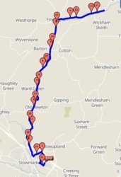
A variation on a theme. As the forecast was for more rain (yesterdays did`nt really materialise) I thought I`d take the chance at 9.15 whilst it was still dry. For a change, as I have got fed up with the muddy routes, I thought that I`d stick to the better roads and just do an out and back to Wickham Skeith. This took me directly to Bacton on the B1113 passing through Old Newton first and then on to Finningham where I turned right by the pub to Wickham Skeith. I continued through Wickham Skeith until I clocked up 10.8 miles where I turned around to follow my route back. One side note. The speed sign at Wickham Skeith had me at 18mph, correct, but why in red as it should have been in green being a 30mph limit ?
Having a tailwind out made me feel almost superhuman but I paid for that on the way back into a 15mph wind from the south. Not an outstanding or memorable ride, it rained a little but not unduly so and guess what ? No mud on the roads, result I would say ! Total distance 21.6 at 17.1 mph average and 889 feet of climbing. It was just nice to be out.Happy days.

494370
 

Rickshaw Phil

Overconfidentii Vulgaris
Moderator
After another wet start to the day it looked like the weather was going to clear up so took my chance to get out, heading over Lyth Hill towards Condover, Ryton and Longnor.

I had thought about doing something a bit longer today but at Ryton I was looking straight at more shower cloud rolling in and before getting to Longnor the rain was coming down. I decided to just do my Acton Burnell loop and headed in that direction. The shower blew through before I got there but it looked like there was more following behind so I wasn't tempted to change my mind again about the route.

I had a good following wind through Pitchford and at Cantlop and there was even some sunshine but a check over my shoulder showed the cloud still chasing me.

At Condover it was school kicking out time so there was a lot of traffic on the road. With the tailwind I thought the main road route would be best but the breeze didn't seem to help as much as I'd hoped. Approaching the A49 there was quite a queue for the junction which I decided to filter past. The rain had caught up by now so I just wanted to get back as quick as possible and fortunately I just caught a good gap to get out onto the main road.

18 miles at 13.5 mph average. Not the ride I'd hoped for but it feels good having got out regardless.

494374

At Ryton. It's not looking very promising up ahead.

494375

Acton Burnell.

494376

Near Condover. The sun breaks through a curtain of rain.
 

pjd57

Veteran
Location
Glasgow
494435


I had a " to do list "
Started by making a short family visit to Clydebank.
Then back into Glasgow , east end to drop off something to my daughter, then on to the Fort shopping centre at Easterhouse.
It was pretty wet by the time I got there.
Quick bit of Christmas shopping there then headed to the shop at Celtic park for some more.
Glasgow Green , then back to Maryhill .
Tesco shopping , which I put into the boot of my wife's car as she works nearby, then finally headed home. Soaked.

Just got my bike away when I found her car keys in my jacket pocket.
Bike back out and another 5 mile round trip in the rain to return her keys.

40 miles in total.
Enjoyed it despite the weather.
 

twentysix by twentyfive

Clinging on tightly
Location
Over the Hill
I headed out into some sunshine and aimed straight for the lanes. No flash flooding this time. On down to Redmarley is a well worn route but I hadn't been this way for a while. On to Brand Green and Highleadon was also renewing my acquaintance. Up on Woolridge the flooding in the valley was clearly extensive. I opted to check out the floods at Ashleworth and had a lovely chat with a nice lady. Up on the flood dodge route of Wickridge Street I decided to mess about in the lanes at Hasfield and check out more of the flooding. It's not often I have a play in these lanes. Heading for Tirley Knowle a rainbow lay ahead. Try as I might I couldn't catch it. More flood inspection took place at Chaceley before it was necessary to head home as the sun was getting low. One last look at the flooding at New Street revealed that up stream, at least, the waters are dropping. With my lights on I rode that last few miles home. Lovely mild and bright day with some sun and blue bits of sky. 56 smiles
494498


494499


494502


494503
 

Old jon

Guru
Location
Leeds
It does rain here, and early in the morning it demonstrated that, but by the time I was ready to move the weather was fine. So I set off down the hill as usual but instead of turning right to aim for Beira Mar I carried straight on, to investigate the recently resurfaced roads we saw last weekend. And they start, this morning, in Joao Paulo.


This is the next village or suburb north, it seems to have rather elastic boundaries depending what the cab driver feels like I guess. Anyway, the road through here was crap when we last saw it in May, a badly treated layer of almost setts or flat cobbles that were uncomfortable in a car being driven over them. On a bike, torture. Now, great with some care. This road leads to a bridge over the main road here, the SC 401. Santa Catarina, pronounced staccato, is the state that incudes Florianopolis.

After crossing this very busy highway there is a large shopping area to the left and the road leads straight on through what my infinitely better half calls a favela. It is somewhat scruffy and that is the only resemblance to the popular opinion of these places that I noticed. This bit of road had been tidied up earlier in the year but where the houses stopped so did the smoother road. Today, the last hundred yards or so is in the process of beautifying. I rode and walked through the chaos, using the pavement when possible, otherwise trusting to luck.

Back on good tarmac, the road parallels the SC 401 for a while then crosses it using an underpass. After a bit turn right. The road goes UP, and down but only to return to uppercase again. The second rise had some runoff water carrying some mountainside muck running down the edge. No traction at all, I took the lane and gained grip while being thankful it is a quiet road. A final descent leads to the beach at Cacupe, home of my second favourite fish restaurant of all time. The favourite is in the south of the island, but there are many others . . .

A big rock and a right hand bend marks the end of this beach. Ride round the bend and the road, guess what? Rises. That one was a struggle. This is to be expected, the road stays close to the coast, there are some wonderful views on a clear day, but by ‘eck there is some climbing. My eventual aim is to ride much further, to Sant’ Antonio de Lisboa. Another village with a long list of things, mostly bars and live music, to commend it. But for now, two more climbs after the one out of Cacupe and that is far enough. The only sensible way home is the reverse of the route here.

One of these days I might just find a circular route of a distance and height gain I can cope with. On the pedal around this morning I did wonder where my fitness had gone, the hills did not look that bad,but I had to stop and rest on three of them, and the bike has a fair range of gears, 50 and 32 or so in front and eleven to twenty eight ( ish again ) in seven on the back. Then the Garthing told me almost 15 miles. And over 1200 feet of up. Ah well, mayhap some climbing practice is in view. And at the top of the final climb our lass was waving from the balcony. She did not see my grin, but knew it was there.

More map of somewhere different,

27112019.jpg
 

galaxy

Veteran
With work and Farther In Law being terminally ill with Asbestosis getting out time has been limited. Forgot how bad the weather has been till i statrted riding. Roads into Leominster surounded by wet fields, still a few fields with Spuds in theat wont be harvested now. Poor farmers have it quite bad.
Still a nice 13 mile loop on the Galaxy, lets you forget about life for a hour or so.
 

Donger

Convoi Exceptionnel
Location
Quedgeley, Glos.
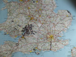
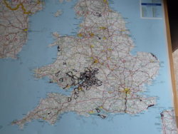
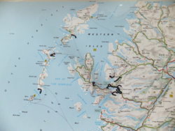
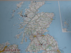
I've been adding rides to this, my favourite, thread for several years now. What I also do is to ink them in on my paper local maps too, then eventually transfer them onto two laminated wall maps. Hopefully, one day these will form a very nice souvenir of my cycling. It is quite nice to be able to compare photos of my UK wall map from May 2015 and the most up-to-date one from November 2019 to see how many new roads I have inked in over the last four years. (Quite a lot of South Wales, bits of Kent and North Yorkshire, and a few more Scottish bits). Must admit it doesn' look like nearly 24,000 miles of UK cycling .... as so much of it has been done multiple times. I was also a bit disappointed how insignificant more than 1,400 miles of overseas cycling looks on a wall map of Europe (albeit a larger scale one). Must do a tour one day:
494558 494559
Southern UK, May 2015 ................. Southern UK, November 2019

494560 494561
Northern UK, May 2015 ................. Northern UK, November 2019

494562

France, Belgium & The Netherlands by November 2019.

Looking forward to having many more rides to write up, and to filling in a lot more on these maps. Does anyone else do anything similar?
Cheers, Donger.
 
Last edited:

C R

Guru
Location
Worcester
I've been adding rides to this, my favourite, thread for several years now. What I also do is to ink them in on my paper local maps too, then eventually transfer them onto two laminated wall maps. Hopefully, one day these will form a very nice souvenir of my cycling. It is quite nice to be able to compare photos of my UK wall map from May 2015 and the most up-to-date one from November 2019 to see how many new roads I have inked in over the last four years. (Quite a lot of South Wales, bits of Kent and North Yorkshire, and a few more Scottish bits). Must admit it doesn' look like nearly 24,000 miles of UK cycling .... as so much of it has been done multiple times. I was also a bit disappointed how insignificant more than 1,400 miles of overseas cycling looks on a wall map of Europe (albeit a larger scale one). Must do a tour one day:
View attachment 494558 View attachment 494559
Southern UK, May 2015 ................. Southern UK, November 2019

View attachment 494560 View attachment 494561
Northern UK, May 2015 ................. Northern UK, November 2019

View attachment 494562
France, Belgium & The Netherlands by November 2019.

Looking forward to having many more rides to write up, and to filling in a lot more on these maps. Does anyone else do anything similar?
Cheers, Donger.

Great idea, how do you mark, pins at the start/end? I can't quite work it out from the photos.
 
Been messing about a little with a certain virtual cycling platform but a weather window opened - dry and not too cold, so felt that this was the best opporunity for a good bimble. Left just before noon, up my usual route through the Dams to Darnley park and onto Stewarton Road. Engine good, twiddled the granny gears on the big climb to keep my HR in check (not ashamed), fabulous descent all the way to Stewarton, then pushed on to Irvine. An hour and a half in and felt great.

Got to the harbourside where the air was perhaps the clearest I have ever seen it. From the harbour entrance I was able to see the Paps of Jura more than 50 miles away.
I got a chance to use my camera that has been gathering dust for years.
1574986951563.png
1574987510083.png

Paps of Jura disproving flat earthers (they're the pillars of Heracles-looking mountains in the far distance with what looks like open sea between them)
1574988561998.png


1574986938180.png

Steed with Arran in the background

1574986964169.png

Arran

1574987029420.png

Looking south across the bay towards Girvan

It started to get cold and daylight was burning so turned around and headed back, but rather than go back up the long drag I had powered down on the way here, the wind had turned so I chose the lowland route along Garnock Valley.

It all fell apart after Kilwinning as I realised that my legs were not able to produce any power as I climbed up from the old railway bridge that carries NCN7.
1574986919363.png


I was still 30 miles away from home and starting to get hurty but trundled along aware of the encroaching night. I also got completely lost because of the new Dalry bypass and ended up on a very busy, unpleasant road (the A737) for 3 horrid miles instead of the sedate lane I was used to. By the time I regained my bearings I headed to my old faithful, Castle Semple Loch, arriving just as the sun was about to go down.
1574986910431.png
1574987054884.png


As soon as the sun disappeared the temperature dropped sharply (Garmin reckons -2.5'C, the old railway paths started to glint in the beam of my front light) and I tried to get some warmth into my legs for the last drag home, but with no stamina left what is normally an easy ride was much more challenging and I found myself struggling to maintain double digit speed at times.

Broken by the time I got back, 4 hours after setting out from Irvine, fighting rush hour traffic with shouty legs was not fun.

All in, 58 miles, 2400 feet of elevation and a deep sense of how bad I really am at cycling :surrender:
1574988428711.png
 
Last edited:
Top Bottom