Your ride today....

Page may contain affiliate links. Please see terms for details.
Lovely sunny morning so I went east to Selby. There and back and no faffing about. More wind in my face than I expected, in both directions as well. Not much going on to be honest but that's what happens sometimes, or not.

40.5 miles and 1250 ft of up.


View: https://ridewithgps.com/trips/46797401

By a curious coincidence my last ride was through Selby's German twin town, Leinfelden-Echterdingen.

513252


I'll take a picture of the sign next time...
 
Last edited:

Archie_tect

De Skieven Architek... aka Penfold + Horace
Location
Northumberland
Leinfenden-Echterdingen.
that's easy for you to say...
 

Mike_P

Guru
Location
Harrogate
IT decided to order improve the capacity of the main work at home connection to the office computer to restrict access to the secondary one between 1 and 3 today, must be some logic there somewhere. Guess who uses the secondary one – take lunch they suggested, which I interpreted as then go out on the bike. So an early afternoon ride and warm enough to leave the leg warmers in the drawer. Avoiding the narrow paths in the country park resulted today in heading west on the A59, to also avoid the climb of the lengthy middle Oaker Bank, only one HGV passed westbound before I reached Hampsthwaite crossroads although eastbound was a bit more hectic.
513298

Normally my outbound route would be northbound from left to right, so it was a rare case of an outbound ride turning south to tackle Burley Bank and then head west along Penny Pot. At the right turn onto Penny Pot a lack of social distancing occurred as a car turned right from the east with the drivers window partially down:angry: It had been noticeable that the southerly wind was not as light as predicted and it was a slower than normal slog upgrade pass the, closed, Sun Inn on the way to Norwood. East along Broad Dubb Road so a cross wind but then it heads south-east so a cross head wind and the climb next to Little Armscliffe was plainly going to be slow as on the approach the speed stayed firmly with the first digit of 1 rather than the normal 2:sad:
513297

Then down to Beckwithshaw and onto the western extremity of the World Championship circuit, nice smooth roads…thought I had a puncture or two the ride was very rough as a I descended the upper parts of Pot Bank:ohmy:
513296

Slow around the bends, and over the bridge for the climb of the lengthy southern Oaker Bank
513295

along which evidence of the Championships still clings on.
513294

Reached 34.4mph on the decent of the middle Oaker Bank, the one outbound I was avoiding climbing. 15.91 miles @ 13.1 mph avg and 1138ft climbed and back home just before 3. Job done:okay: oh – hang on back to the job…
513293

513292
 

Donger

Convoi Exceptionnel
Location
Quedgeley, Glos.
A bit of a mixed bag tonight, with some learning points. As I was getting a bit bored with riding the same lanes close to home over and over again, I headed northwards instead this evening, along the cycle path at the side of the Gloucester Western By-Pass. As this is only barely 2 metres wide, I was glad I didn't meet anyone coming the other way, as I wouldn't have liked to have to move right to the edge of the by-pass on one side or into the brambles on the other side of the track. I did a detour into Hempsted and decided to go along a little lane down near the Severn at the Rea. That was another mistake. Everyone and their wives were down there walking in pairs, and the lane wasn't wide enough for social distancing. I turned tail and carried on around the by-pass cycle path and across the Severn near Thomas Telford's old bridge, eventually turning back when I hit 6 miles from home at Highnam Court roundabout.

On the way back I took in the "Highnam mile" ... a one mile long estate road surrounding the housing estate at Highnam, before making use of a big wide bus lane on the way back to Gloucester. The usually appalling Over Roundabout was completely traffic-free when I got there, which was a real novelty. Curiosity got the better of me, and I detoured through Gloucester city centre which was eerily quiet. I passed the Land Registry, where I worked for 36 years. No traffic at all, but the usual collection of five or more drunks were lying around on the grass outside as always. I criss-crossed my way across the city, passing the park and the infamous Cromwell Street before crossing the canal and passing through the near deserted docks. After a quick sprint down the A38 to Tuffley, I returned home through the Kingsway estate, getting back in about 1 hour 15 mins, having done 16.9 miles. I enjoyed the second half of the ride, but won't be using that cycle path again. Quite apart from the width issues, there were far too many broken bottles strewn around for my liking.

Stay safe everyone. Cheers, Donger.
 
Last edited:

derrick

The Glue that binds us together.
Another quick solo spin, still a bit of wind on the way back, but lovely blue skies. Nice beer in the garden when i finished. Nice riding with the roads so quiet.
https://www.strava.com/activities/3266185716#kudos
 
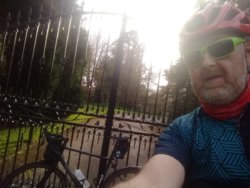
So, today was going to be different: an early start would be made, and moderately epic distances would be cycled.

That was the theory anyway, right up to the point I pulled my back helping Beautiful Daughter to learn to ride yesterday. I decided I could still try, and see what happened: If it hurt from the start, I could always go back to bed, failing that I'd go for a few K's, then complain at everyone for the rest of the day.

Limped my way down the stairs to the garage, I'm not sure why, it's not like limping helps a bad back. Bag on bike. Bike outside, roll gingerly along drive. Back pain almost vanished instantly.

Mwahahaaa...
513315


Plans rapidly went from a gentle pootle around the local farms, to some serious distance, well serious for me anyway. I decided to try for Gutenberg, a round trip of about 75k; two weeks of lockdown have not done anything for my hobbit-like figure and it was time my legs remembered what they were there for, besides, I need some different places to photograph.

513316


I was aiming for a distant valley in the range of hills called the Swabian Jura. This is in fact visible from our kitchen window which is a useful visual aid for showing off later as long as I didn't mention that I was going along the valley so I didn't have to do any serious climbing.

Not unexpectedly no-one was remotely impressed when I pointed this out on my return, which is why I'm going on about it here.

513317


Slightly closer view of the hill, taken from the railway station as Owen, (Pronounced Au-en. don't ask me I jut live here) This was the route I took when I first started cycling slightly longer distances, on the basis that if there's a railway line along the valley it couldn't be that steep, and if I did have to bail I could at least catch the train home. It came in useful more recently, when a client with learning difficulties got on the wrong train and ended up stuck and rather confused on this station. No-one ever managed to work out how she ended up here but at least I knew how to get her back.

But I digress...

513318


I followed the railway pretty closely. The line stops at the village of Oberlenningen and as I didn't want to be out all day, I considered turning there, but I knew that the prettier part of the valley came after this...

513319


It turns out that I have no self control in these matters: I kept going. This is headwater country, the hills are steep and forested, with cliffs and huge rock outcrops, some with farmhouses perched on top, and streams running under the cycleway.

513320


Gutenberg is at the head of the valley. It's higher than my village which is at the top of a hill, but at the south end of the village the road points skyward and winds up the hillside like those roads you get on cartoons, where one side is a cliff and the other is a drop into unknown depths.

In my over ambitious imagination I've planned a route into the hills on an old railway line, that comes back down into this valley so I have a relaxed return to Stuttgart, if for no other reason than the ridge itself is the Rhine/Danube watershed and I like the idea of crossing the continental divide. Mind you, I've been planning that for a while with absolutely no evidence of it happening, so don't hold your breath.

Anyway, it was ten in the morning and I was feeling guilty that I'd be out until after midday, so I took a couple of pictures of the church and village, and went back the way I'd come.

513321


Thankfully, this meant riding downhill for a bit...

513322


So I could make good progress for a while.


513323


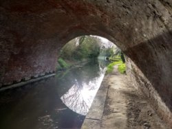
Crossing the river Neckar, According to the memorial the bridge was built in the 1600's, destroyed in 1945 and rebuilt in 1946. It was replaced by a concrete monstrosity a few metres upstream and now serves cyclists and pedestrians.

After leaving the Neckar valley, I can get the first view of my village. The name of the village is taken from an old local word for part of a castle, so it makes sense it is on top of a hill and visible for miles. As I mentioned above this has the advantage of a view from the kitchen window that many millionaires would envy, but it does mean every ride ends with some fairly steep climbing...

513324


It could be worse though...
 
Last edited:

Jenkins

Legendary Member
Location
Felixstowe
Under normal circumstances on a beautiful day like today. I'd have done a long loop into the countryside or a one way trip to somewhere like Newmarket or Lowestoft and got the train home. However I'm trying to show a little bit of responsibility by staying fairly local so all I did was 2 x 25.5 mile laps of a circuit from home to Levington & Nacton. turning up the Bucklesham Road at St. Augustine's roundabout then diverting up to Kesgrave, back down through Martlesham to Bucklesham and a quick loop of Kirton. It really was lovely out there in shorts & a short sleeved top!
Levington (2).jpg

Screenshot_2020-04-07 Sunshine, shorts surprising speed Ride Strava(1).png
Screenshot_2020-04-07 Sunshine, shorts surprising speed Ride Strava.png

https://www.strava.com/activities/3266449215
 

AndreaJ

Veteran
More sunshine today and I have a weeks holiday off work as my daughter is going a bit stir crazy at home on her own all day, we made it till today before she asked if I was going on a longer ride yet😂. I set off to Whixall, Fenns Bank, Fenns Wood over the canal to Alkington, back to Hollinswood, Tilstock, Prees, over the railway back to Coton, Coton Wood, Braynes Hall, Waterloo,through Edstaston back onto the Whitchurch Road, Creamore, Ryebank, Foxholes, Horton and back home. The traffic is the same as usual here but more people out walking than usual, quite a few cyclists about, some of them looked like they were dressed for the middle of winter! 33.01 miles @15.7mph without getting too far from home.I’m lucky this part of deepest darkest rural North Shropshire has lots of lanes to use without needing to go down the same one twice.
 

Mr Celine

Discordian
I got fed up pretending to work from home, more so because the sun was out. I'm due three days worth of excercise so went out to use up two of them and by using the now quiet main roads don't need to social distance from any peds. The summer bike has being going fine on it's two previous outings but today decided to throw the chain twice in the first ten miles. And I've only just re-wrapped the bars with pristine white bar tape.
The only stop apart from those mechanicals was on Kelso Bridge -
513333

This is looking upstream to the Junction Pool, a famous salmon beat, where the River Teviot (on the left) joins the River Tweed. The bridge was built by John Rennie and he copied the design for his Waterloo Bridge in Londonshire.

Today's map -

1586293028929.png


33.7 miles @16.4 mph 513m up.
 

Arjimlad

Tights of Cydonia
Location
South Glos
I had a lovely sunset ride on Monday evening. Climbed Coxgrove Hill, through Pucklechurch and up Hinton past the Bull.

When I got to the A46 I was running short of time so I rode north to j18 of the M4. Never seen it so deserted!

After that, I bombed past Mr Dyson's house at Dodington, before turning west along Dodington Lane & returning home via Yate. My son had been out on a short ride & I caught up with him a couple of miles from home.

My relatives like to see the videos from my rides so I have put one together from this one


View: https://youtu.be/lqwkPOZ6oSc


513414


513415


513416


513417
 
Last edited:
Under normal circumstances on a beautiful day like today. I'd have done a long loop into the countryside or a one way trip to somewhere like Newmarket or Lowestoft and got the train home. However I'm trying to show a little bit of responsibility by staying fairly local so all I did was 2 x 25.5 mile laps of a circuit from home to Levington & Nacton. turning up the Bucklesham Road at St. Augustine's roundabout then diverting up to Kesgrave, back down through Martlesham to Bucklesham and a quick loop of Kirton. It really was lovely out there in shorts & a short sleeved top!
View attachment 513330
View attachment 513331 View attachment 513332
https://www.strava.com/activities/3266449215
I bet it was fairly quiet at St.Augustines ? I used to work in Felixstowe Road and I had two routes I did lunchtimes, if I had an hour lunch. One was to cycle along Bucklesham Road to the school, sometimes a bit further and then back. I did try going up to Brightwell and then back along Foxhall Road but that was too busy and a nightmare getting across the A12. The other route was to cycle up Bixley Rd to Foxhall Rd, turning right and along Foxhall Rd as far as Broadland Drive, turning left here and then doing about 8 laps on this estate which was just under a mile per lap. Lunchtimes it was quiet. But the worst bit was always either Bixley Drive and St.Augustines. Sometimes I`d cut through Broke Hall.
 
Top Bottom